Old indian loot cache

forgetaboudit

Full Member
Feb 15, 2014
133
67
Milwaukee
Primary Interest:
All Treasure Hunting
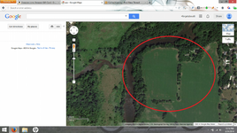
So there is a story that some Indians left a cache on the East side of a river (I'll leave unnamed) near where a creek sprouts off the river. I think I might've found the location of the river and creek, but the area where the story says the cache should be is now a farmer's field... From the satellite map, there are trees on the river banks, and also the edges of the field. There doesn't seem to be any landmarks that they would've used. Any ideas? Should I try to contact the field owner and maybe try detecting the field? It seems like a daunting task.
I added this photo in hopes i can get some tips maybe. There are other details, but I wont say spill all the beans here.
Untitled_zps7cda663a.png
 

prospect007

Full Member
Mar 16, 2014
140
53
western us
Detector(s) used
minelab 4000,fisher gb2,f75
Primary Interest:
All Treasure Hunting
If the Indians left a cache, I don't believe it would be gold or silver. probably tools they left when moving from camp to camp, left under a rock or over hang for protection. probably camped away from the water (100yrds or so)so they could hear there enemies coming over the noise of the water. good luck, hope you find something there.
 

OP
OP
F

forgetaboudit

Full Member
Feb 15, 2014
133
67
Milwaukee
Primary Interest:
All Treasure Hunting
If the Indians left a cache, I don't believe it would be gold or silver. probably tools they left when moving from camp to camp, left under a rock or over hang for protection. probably camped away from the water (100yrds or so)so they could hear there enemies coming over the noise of the water. good luck, hope you find something there.

The story says it was (something significant)...I won't exactly say what it was, but was something definitely worth finding.

Sent from my LG-LS980 using Tapatalk
 

prospect007

Full Member
Mar 16, 2014
140
53
western us
Detector(s) used
minelab 4000,fisher gb2,f75
Primary Interest:
All Treasure Hunting
how old is the story? I'm not saying there's nothing there,(I hope there is something) just saying pre-15-1600's there was no need for money, in the since we know of today. what is a lg-ls980? sounds interesting. good luck
 

OP
OP
F

forgetaboudit

Full Member
Feb 15, 2014
133
67
Milwaukee
Primary Interest:
All Treasure Hunting
how old is the story? I'm not saying there's nothing there,(I hope there is something) just saying pre-15-1600's there was no need for money, in the since we know of today. what is a lg-ls980? sounds interesting. good luck

Says the cache was buried in 1834 after the government made the final payment to them for the land. Is there a way I can check with the state and see if there are any records of payment and or location of said land?
 

Crosse De Sign

Gold Member
Jun 19, 2013
5,490
5,757
~: Ancient Sacred Spirit Lands Of Our Fathers' :~
Detector(s) used
White's MXT ~ TM800 ~
Primary Interest:
Other
Says the cache was buried in 1834 after the government made the final payment to them for the land. Is there a way I can check with the state and see if there are any records of payment and or location of said land?
:coffee2:8-)Hi, If You Can Get The Farmer Interested, Then Say, Make A "Treasure Deal" With Him... Then Take Your Time, And Get Whatever Equipment You Need To Check The Area... Wouldn't Be The First Time Indians Buried Their Gold Coins, Like The Cherokee Cache (US Gold For Land Payment), Supposedly Buried By The Chief In The Late 1800's, But Said To Never Have Been Recovered, Somewhere On Their Tribal Headquarters Land... Good Luck!
 

prospect007

Full Member
Mar 16, 2014
140
53
western us
Detector(s) used
minelab 4000,fisher gb2,f75
Primary Interest:
All Treasure Hunting
I think you have a shot at finding something good. talk with the farmer, the worst he can say is no. The hunt sounds fun.
 

huntsman53

Gold Member
Jun 11, 2013
6,955
6,769
East Tennessee
Primary Interest:
Other
After securing permission to hunt the land from the property owner, I would start by walking the river bank as well as above the mean high water line, looking for any possible landmarks that would have been of use to the Indians. If some are found, then you might start your search around these and especially areas above the mean high water line near these. If none are found, then I would start searching above the mean high water line directly across from the creek, then upstream and downstream from there as this is your only landmark to go by and was probably their's as well. Surely the Indians would have buried the loot above and possibly beyond the mean high water line to not risk it being washed out and found or lost.


Frank
 

10claw

Sr. Member
Aug 16, 2009
495
140
:coffee2:forgetaboudit
, go across to the other side of the river and look for the highest hill, if there is one, look at the oldest trees for carved signs. If trees are,nt old enough, look for signs on rocks. also once you get farmers permission look good on that side also.
let us know how that works out, good or bad?
thanks, now have another cup
:coffee2:
 

OP
OP
F

forgetaboudit

Full Member
Feb 15, 2014
133
67
Milwaukee
Primary Interest:
All Treasure Hunting
how old is the story? I'm not saying there's nothing there,(I hope there is something) just saying pre-15-1600's there was no need for money, in the since we know of today. what is a lg-ls980? sounds interesting. good luck

LG-ls980 is my LG G2. Its one of the best phones available right now, and I love it!

Sent from my LG-LS980 using Tapatalk
 

releventchair

Gold Member
May 9, 2012
22,349
70,457
Primary Interest:
Other
Study traditional camp sites. You have the popular two branches of water. Where to stretch out to sleep? Trees to avoid being under may be long gone but somewhere is better odds of where to have a shelter even if only a tarp for privacy to bury an item(s) under your bedroll. Current steam locations may not be where they were before. Upstream areas today often farther from water before erosion knocked ends away. Watching it in spring run off high water conditions shows what happens today,may or may not be similar to past but near me the river crawls into the woods a long ways. Natives were camped up the smaller stream side of" V" a ways at one time. However in summer ,being on the point allows a view up each water body. There a now deceased Indian screened for relics on downstream end at least once he said. Also along river drainage near here are "mounds",not all for burial ,I would never bother one but they give an idea of at the time distance from water of activities. Farther south under a hundred miles is an earthen bank. A pit/trough on one side ,(inside) of what once was a vertical log wall. Both sites are tied by what was left.
 

OP
OP
F

forgetaboudit

Full Member
Feb 15, 2014
133
67
Milwaukee
Primary Interest:
All Treasure Hunting
Study traditional camp sites. You have the popular two branches of water. Where to stretch out to sleep? Trees to avoid being under may be long gone but somewhere is better odds of where to have a shelter even if only a tarp for privacy to bury an item(s) under your bedroll. Current steam locations may not be where they were before. Upstream areas today often farther from water before erosion knocked ends away. Watching it in spring run off high water conditions shows what happens today,may or may not be similar to past but near me the river crawls into the woods a long ways. Natives were camped up the smaller stream side of" V" a ways at one time. However in summer ,being on the point allows a view up each water body. There a now deceased Indian screened for relics on downstream end at least once he said. Also along river drainage near here are "mounds",not all for burial ,I would never bother one but they give an idea of at the time distance from water of activities. Farther south under a hundred miles is an earthen bank. A pit/trough on one side ,(inside) of what once was a vertical log wall. Both sites are tied by what was left.

A lot of this area is now developed into housing or all stripped for farm land. I'm sure a lot of the landscape is far changed from what it was.

Sent from my LG-LS980 using Tapatalk
 

releventchair

Gold Member
May 9, 2012
22,349
70,457
Primary Interest:
Other
I,d check N.W. edge first of intersection of two streams.Then S.W. section. Wild guess from existing banks up to around a hundred yards from water. Other things were cached at seasonal camps . Some places used during different parts of the year for different reasons. Steam delta,s contained greater amounts at times of life/food per square foot as well as ties to trails but a passenger pigeon roost nearby could divert traffic as well. That water intersection a draw though for a rest.Wash stuff one side and drink out of the other.
 

Rob in KS

Hero Member
Aug 21, 2006
648
213
Middle of Kansas
Primary Interest:
All Treasure Hunting
Look for the oldest topo map you can find of the area. That'll help with the creek movement.
Check for any records of the land purchase, what tribe, etc. To verify the story.
Hopefully your county tax records are on line so you can easily find your landowner(s).
 

SusanMN

Silver Member
Jun 1, 2007
4,534
4,098
Minnesota
Detector(s) used
Tiger Shark, Xterra 705, Makro Legend
Primary Interest:
All Treasure Hunting
Says the cache was buried in 1834 after the government made the final payment to them for the land. Is there a way I can check with the state and see if there are any records of payment and or location of said land?

Records should have been kept in the 1820s. I know that I had no difficulty finding information about the payments made to my indian ancestors during this exact time period, including the name of each person who was paid and the amount. Try googling the tribe name and land payments and see what you get.
 

michigan_twobox

Jr. Member
Jun 23, 2012
53
30
I think I know what treasure legend you are talking about. I would get a twobox and grid that whole area. Let me know if you need some help. Did the chiefs name start with a w?
 

Top Member Reactions

Users who are viewing this thread

Top