$20M gold cache ******

Frankn

Gold Member
Mar 21, 2010
8,711
2,989
Maryland
Detector(s) used
XLT , surfmaster PI , HAYS 2Box , VIBRA-TECTOR
OK put your thinking cap on. get out the maps and see if we can narrow this down.

Some of us dream of finding a large nugget or a piece of quartz lased with gold, I am one of them, but I also dream of finding a gig cache of gold.
Here's the condensed version of a $20 Million Gold Cache.
In 1933 the US Gov. outlawed the private ownership of gold. A Mexican Citizen attempted to sell to the US Gov. $20M in gold cached in NW New Mexico.
The deal was turned down. The last attempt at a deal was 1952. It was turned down. Oh yes, the Gov. tried to find it, but failed. Here's the info they used to hunt for it. 16 flights of a small plane were required to move the gold. The plane landed at a 7,000' mesa between the landmarks described.
-the Ute Mountain Indian to the east, the Navajo Indian Reservation, Kirkland and Shiprock Peak to the south. The burial site is described as being 2 to3 miles from the landing site.
Now some questions: How long would the runway have to be to land a heavily laden small plane.
: How big would this Mesa be if the cache was buried 2 to 3 miles from the landing spot.
Note: I suspect the cache was buried closer to the landing site. There were no vehicles on the Mesa and gold is heavy
also no labor was available.
Anyone know this area? Frank...- y gold bars.jpg
 

Last edited:

Sod Buster

Sr. Member
Jun 14, 2014
482
487
NE Ohio
Detector(s) used
Garrett Ace 250, White's Bullseye TRX
Primary Interest:
All Treasure Hunting
The only way I can get your landmarks to line up correctly, would be to turn the map 90 degrees CCW. Meaning, now North would be West.
 

San Antone

Jr. Member
Jun 1, 2014
80
81
San Antonio, Texas
Detector(s) used
Bounty Hunter Lone Star,
Garrett Ace 350,
Fisher Gemini-3
Primary Interest:
Other
This is the Leon Trabuca gold. There is a story on it in the Treasure Legends forum.
 

OP
OP
Frankn

Frankn

Gold Member
Mar 21, 2010
8,711
2,989
Maryland
Detector(s) used
XLT , surfmaster PI , HAYS 2Box , VIBRA-TECTOR
The only way I can get your landmarks to line up correctly, would be to turn the map 90 degrees CCW. Meaning, now North would be West.
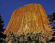
6 06-1 Yellowstone 054-1.jpg I picture it as looking like an oversize Devil's Tower. Is there a 7K' mesa in there? Frank...-
 

OP
OP
Frankn

Frankn

Gold Member
Mar 21, 2010
8,711
2,989
Maryland
Detector(s) used
XLT , surfmaster PI , HAYS 2Box , VIBRA-TECTOR
This is the Leon Trabuca gold. There is a story on it in the Treasure Legends forum.
I didn't see it in there, but I didn't hit all 11 pages either.
This story is documented, not really a legend. My source lists 5 prominent citicens, one who was a mine owner, one a banker, 2 millionaire cattle ranchers,and an economics advisor in the Mexican Gov. of that time. They all are dead now.

I thought maybe if we got enough brain power together, maybe it could be cracked. Hay, it gets you closer than Fenn does! lol. Frank...-
111-1 profile.jpg
 

maipenrai

Bronze Member
Nov 11, 2010
1,151
242
Thailand/Europe/California
Detector(s) used
Excalibur 2 1000
Primary Interest:
All Treasure Hunting
So, how would they haul 17 tons of gold, 2 miles from the plane, if they had no transportation? Why not just bury it where they landed?
 

Salvor6

Silver Member
Feb 5, 2005
3,755
2,169
Port Richey, Florida
Detector(s) used
Aquapulse, J.W. Fisher Proton 3, Pulse Star II, Detector Pro Headhunter, AK-47
Primary Interest:
Shipwrecks
Frankn if you read the 17 tons of gold thread you will see that they did not land on the mesa. They also had a truck to transport the gold. A broken fender was found on the trail that came from this truck. The consensus is that the gold is now gone. F. Lee Bailey was one of the lawyers that tried to negotiate a deal with the govt. The gold was moved from the original hiding spot 2-3 miles from the landing zone. Many have searched for this cache. Many have failed. Also, it's on Indian owned land. Good luck!
 

OP
OP
Frankn

Frankn

Gold Member
Mar 21, 2010
8,711
2,989
Maryland
Detector(s) used
XLT , surfmaster PI , HAYS 2Box , VIBRA-TECTOR
Well, I read the 17 ton story. The one I read is slightly different. In it they landed on a 7K' mesa elevation and stashed it on top. The negotiations with the Gov. are the same. Maybe the Gov. got it like Noss's find. They have the technology to get it with the GPR sats and IR sats. Frank...-
111-2 700 head of old man.jpg
 

cw0909

Silver Member
Dec 24, 2006
4,364
3,222
Primary Interest:
Other
frankn im game, to start the research here is a topo map of the shiprock area, i think it was done in the 50s,60s
This page contains links to all of the USGS DRG Topographic map TIFF image files for the state of New Mexico. If you are on a slow link go to this page for compressed maps.
New Mexico USGS DRG Topographic Map Index
 

cw0909

Silver Member
Dec 24, 2006
4,364
3,222
Primary Interest:
Other
i remember reading about that gold 1 time, and i thought i read something about leon had bought
an old sheep camp, but i might not be remembering that right, ill look around
 

Curtis

Hero Member
Sep 3, 2008
899
1,009
Cincinnati
Primary Interest:
All Treasure Hunting
Hi Frankn,

This is a really good story, I read it years ago and there is enough out there to convince me that it really happened. Someone was there and found a part(generator I think) that probably came off of the truck....along with the fender. It means someone left some physical evidence to the story....there are also people who can tell you exactly where the workers stayed(old houses/shelters) that they stayed in while they did the unloading...I'm all for putting our heads together for this one....like someone said its more likely to find than Fen's!
 

OP
OP
Frankn

Frankn

Gold Member
Mar 21, 2010
8,711
2,989
Maryland
Detector(s) used
XLT , surfmaster PI , HAYS 2Box , VIBRA-TECTOR
frankn im game, to start the research here is a topo map of the shiprock area, i think it was done in the 50s,60s
This page contains links to all of the USGS DRG Topographic map TIFF image files for the state of New Mexico. If you are on a slow link go to this page for compressed maps.
New Mexico USGS DRG Topographic Map Index

Well, I just spent an hour on that topo and can not find a 7000' mesa in the described area. That is rough territory. Frank...- 111-1 profile.jpg
 

Peyton Manning

Gold Member
Dec 19, 2012
14,533
18,682
🏆 Honorable Mentions:
1
Detector(s) used
MXT-PRO
Sandshark
Primary Interest:
Metal Detecting
sheesh I would have taken it to a country that allowed gold ownership
 

cw0909

Silver Member
Dec 24, 2006
4,364
3,222
Primary Interest:
Other
off the Reservations

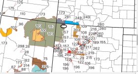
to me if you use shiprock your on an IR, and i just cant go with that idea as
someone, indians, the BIA would have noticed, so i went east off the IRs
took a look around, see jpgs, 1st jpg is a snip from a bigger map of where the
Indian Reservations are, and the black circle above the # 157,is the area near
the dirs that frankn put up
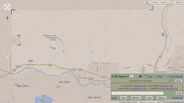
the 2nd jpg is a snip of a recent acme map in map mode, the black markers
i put on the corners, shows the light and darker area, darker area are Reservations
and the lighter area is the area circled in 1st jpg
i havent looked at Gearth mode yet, you can get the coords off the map link
just looking at sat mode,i couldnt see where you could land a plane, that would
take some more investigation
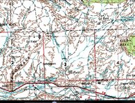
3rd jpeg is a snip from the topo link i put up b4, and close to the area we are
looking at in jpg 1 and 2


where the Indian Reservations are and key
File:Bia-map-indian-reservations-usa.png - Wikimedia Commons


the black circle above the # 157,is the area near
the dirs that frankn put up
ir.jpg


darker area are Reservations
and the lighter area is the area circled in 1st jpg
ir map.jpg


link to the topo used for the snip in 2nd jpg
http://mapper.acme.com/?ll=36.75341...78022,- 108.68206,1.6 mi W of Chaco River NM


snip from topo link i posted b4
ir topo.jpg
 

OP
OP
Frankn

Frankn

Gold Member
Mar 21, 2010
8,711
2,989
Maryland
Detector(s) used
XLT , surfmaster PI , HAYS 2Box , VIBRA-TECTOR
I normaly research and then go for a starting point. After checking out the topos, I can't find a starting point. There are no 7000' mesa's to land on. I also checked out another version of this story and it stated that the gold had been moved twice to avoid the feds finding it. it looked good in the beginning, but I am going to through in the towel on this one and look for another. I am also still working on my 1600 trading post cache site.
Frank...-
111-2 700 head of old man.jpg
 

Last edited:

cw0909

Silver Member
Dec 24, 2006
4,364
3,222
Primary Interest:
Other
red mosier

something odd about red mosier,he was known and successful in the airline
industry, yet i cant find him in a census, yet there is a ancestry record
of who his father is, and the father in 1910 is listed with only one child,
if you google REDS' names there is more info
Red is AKA
O.M. red Mosier, O.M Mosier, Orval Mckinley Mosier, orville M. red Mosier


Orval Mckinley Mosier
Born in Pawnee, Oklahoma, USA on 10 Feb 1897 to William Earl Mosier and Lotta E Harris. Orval Mckinley married Francys Cox Colcord. He passed away on 9 Feb 1967 in Oklahoma City, Oklahoma, USA
Orval Mckinley Mosier


MOSIER, ORVILLE was born 16 April 1897, received Social Security number
329-09-7514 (indicating Illinois) and, Death Master File says, died March 1967
SortedByName.com – Your FREE genealogy site
wife
MOSIER, FRANCYS was born 28 December 1897, received Social Security number
440-48-0800 (indicating Oklahoma) and, Death Master File says, died October 1974
-----------
this is the time period when the gold was flown and hid
Orval M. Mosier
CITY MANAGER
AUGUST 2, 1933 TO JANUARY 1, 1937
https://www.okc.gov/mgr/mosier.html


O.M. "RED" MOSIER
some flight history
The O.M. "RED" MOSIER Page of the Davis-Monthan Airfield Register Website


A A airlines VP heads wings club
Flying Magazine - Google Books

-------------------------------------------
is this our red?, right age wrong location
MOSIER, ORVILLE (1920 U.S. Census)
IOWA , LYON, ROCK
Age: 22, Male, Race: WHITE, Born: IL
Series: T625 Roll: 497 Page: 252
parents birth place listed as unknown
-------------------------------
red father
William Earl Mosier, was born in 1875, in 1897 his age is 22 yet
he is not married at age 23, maybe red was born out of wedlock


William Earl Mosier
parents, JOHN T & ISEBELL, sister ALFA A.
MOSIER, WILLIAM E. (1880 U.S. Census)
INDIANA , MORGAN, GREGG
Age: 3, Race: WHITE, Born: IN
Series: T9 Roll: 301 Page: 74


MOSIER, WILLIAM E (1900 U.S. Census)
OKLAHOMA , PAWNEE, 1-WD RALSTON
Age: 23, Male, Race: WHITE, Born: IN
Series: T623 Roll: 1341 Page: 57
parents born in IN, not married or children
---------------------
MOSIER, WILLIAM (1910 U.S. Census)
OKLAHOMA , OKLAHOMA, 3-WD OKLAHOMA CITY
Age: 33, Male, Race: WHITE, Born: IN
Series: T624 Roll: 1266 Page: 159
wife lotta, son cleo 7yrs, no orvale/orville
parents born in IN
 

Last edited:

cw0909

Silver Member
Dec 24, 2006
4,364
3,222
Primary Interest:
Other
found an area in norrtheast corner of county that has 7k', if you switch to map
mode you can see its not on an IR
marked a few 7000'
ACME Mapper 2.1
 

Top Member Reactions

Users who are viewing this thread

Latest Discussions

Top