Civil War camp

Hillbilly Prince

Silver Member
Aug 9, 2018
4,999
12,712
SW Missouri
Detector(s) used
Garrett All Terrain Pro
Primary Interest:
All Treasure Hunting
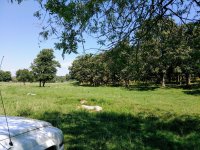
I have permission to search an area where was a Confederate camp. But the exact spot is not known to me. There is a flat area at the base of a ridge.
Where were camps set up? I'm thinking you would have a lookout on the ridge but the main camp would be on the floor. Although in case of attack you would want to be on top. This is how it looks with the ridge to the right. There is a creek about two miles on.
ridge.jpg
 

Upvote 0

fyrffytr1

Gold Member
Mar 5, 2010
7,500
11,870
Southwest Georgia
Detector(s) used
XP Deus, White's DFX
Primary Interest:
All Treasure Hunting
Just my way of thinking but I would want to be close to a fresh water source and up out of any flood plain.
 

OP
OP
Hillbilly Prince

Hillbilly Prince

Silver Member
Aug 9, 2018
4,999
12,712
SW Missouri
Detector(s) used
Garrett All Terrain Pro
Primary Interest:
All Treasure Hunting
Didn't think of that. I need to get back there and explore farther. Maybe it would be good to get on the banks of the creek if I can find out who owns the land.
I've been told the soldiers would have a trench for a latrine and throw some of those big old musket balls in because they got tired of the weight.
 

devldog

Silver Member
Mar 9, 2012
3,645
6,340
Georgia
Detector(s) used
Whites MXT ALL PRO, Minelab Safari
Primary Interest:
Relic Hunting
Hey HP, also when you check this area, around the tops of the ridge look closely to see if you notice any small indentions in the ground in the form of a half moon. These would be what was called Rifle Pits that a soldier could lie behind sort of like a real small trench with earth piled in front of the soldier. I would start out hunting the ridge and slowly work my way down to the lower flat ground. Best of Luck to you.:usflag:
 

Ripcon

Hero Member
Sep 4, 2016
725
1,245
Mississippi
Detector(s) used
Tesoro
Primary Interest:
All Treasure Hunting
I would suggest starting your search at the ridge top. Good luck!
 

Rookster

Gold Member
Nov 24, 2013
29,382
111,597
Detector(s) used
XP Deus, F75Ltd., AT PRO, Garrett pointer
Primary Interest:
Cache Hunting
Good looking spot. Good luck.
 

OP
OP
Hillbilly Prince

Hillbilly Prince

Silver Member
Aug 9, 2018
4,999
12,712
SW Missouri
Detector(s) used
Garrett All Terrain Pro
Primary Interest:
All Treasure Hunting
Hey HP, also when you check this area, around the tops of the ridge look closely to see if you notice any small indentions in the ground in the form of a half moon. These would be what was called Rifle Pits that a soldier could lie behind sort of like a real small trench with earth piled in front of the soldier. I would start out hunting the ridge and slowly work my way down to the lower flat ground. Best of Luck to you.:usflag:

That is great info and a real help. Thanks! You gave me an idea. There are photos of the battlefields online. So I thought there are probably photos of camp life. Here is a link to a site I found after a couple of minutes which is pretty neat. Maybe some books out there as well.

https://www.nps.gov/gett/learn/photosmultimedia/then-and-now.htm
 

releventchair

Gold Member
May 9, 2012
22,393
70,704
Primary Interest:
Other
Where would you keep horses there? There is open ground to keep them grazing on picket pins.
Those trees may not have been on the ridge back then.
Shade ,depending on the weather ; would have been appreciated.

Two miles seems quite a ways for water. Unless another force was on the creek...

History of troop movement might sort out how long they actually camped there. Or if it was just a brief rest.
 

OP
OP
Hillbilly Prince

Hillbilly Prince

Silver Member
Aug 9, 2018
4,999
12,712
SW Missouri
Detector(s) used
Garrett All Terrain Pro
Primary Interest:
All Treasure Hunting
I would suggest starting your search at the ridge top. Good luck!

Thanks! My brother got a signal with his old Tesoro about fifty feet off the peak of the ridge and we dug a bunch of old melted lead. So I am thinking we can find more.
 

OP
OP
Hillbilly Prince

Hillbilly Prince

Silver Member
Aug 9, 2018
4,999
12,712
SW Missouri
Detector(s) used
Garrett All Terrain Pro
Primary Interest:
All Treasure Hunting
Where would you keep horses there? There is open ground to keep them grazing on picket pins.
Those trees may not have been on the ridge back then.
Shade ,depending on the weather ; would have been appreciated.

Two miles seems quite a ways for water. Unless another force was on the creek...

History of troop movement might sort out how long they actually camped there. Or if it was just a brief rest.

All good points. I try to put my mind in the heads of the men. Missouri is an oven in summer around here-got to have water, shade, grazing. Got to do some homework on this one. I did not spot any big old trees
in our short visit.
 

Last edited:

releventchair

Gold Member
May 9, 2012
22,393
70,704
Primary Interest:
Other
All good points. I try to put my mind in the heads of the men. Missouri is an oven in summer around here-got to have water, shade, grazing. Got to do some homework on this one. I did not spot any big old trees
in our short visit.

Stumps count.
Field may have been cleared post war too...

IF the ridge was used to create a screen to conceal troops and stock from a nearby main route at the time ,what side of the ridge would have been the concealed side?
 

OP
OP
Hillbilly Prince

Hillbilly Prince

Silver Member
Aug 9, 2018
4,999
12,712
SW Missouri
Detector(s) used
Garrett All Terrain Pro
Primary Interest:
All Treasure Hunting
Stumps count.
Field may have been cleared post war too...

IF the ridge was used to create a screen to conceal troops and stock from a nearby main route at the time ,what side of the ridge would have been the concealed side?

I'll have to look again at a map of troop positions at the time the fighting for Missouri was going on but as I recall the side in the photo is where I think they would have been with the expectation of Union to the North. The old road would have ran North and East of the ridge top. Expected attacks would come generally from the North I think.
Horses picketed on the flat area with troops on the ridge. Think the land was cleared as that is the rule in a lot of Missouri.
 

Last edited:

Worm-Slicer

Hero Member
Jan 6, 2013
633
1,099
SouthwestVirginia
🥇 Banner finds
2
Primary Interest:
Relic Hunting
I would first try to see if I could locate old roadbeds (if I couldn't find an actual Civil War era map). These can sometimes be tricky to see, especially in summertime, but look for deep gullies and you'll know it's an original roadbed if you detect it as you will find horseshoes all along it. Water sources would be next then I would look for suitable flat areas, slightly elevated with good drainage. If that doesn't work, I would look for suitable flat areas that are farther from water. Most were, but not all camps were located near water. I've read accounts of soldiers having to walk a mile or more from camp to get water. In my opinion, though, original roads are the number one way of locating campsites.
 

gsxraddict

Hero Member
Sep 21, 2005
629
413
Resaca, GA
Detector(s) used
XP Deus, Minelab Equinox 800, Whites V3i
Primary Interest:
Relic Hunting
try the back side of the hill away from where the enemy would be. I find they often used the face of the hills as cover but they stayed on the sides of them.
 

1320

Silver Member
Dec 10, 2004
3,434
2,308
East Central Kentucky
If I were in your shoes, I would first research the camp, just to make sure I'm not on a wild goose chase. Make sure it exists AND lies in your target area. It would be very important to determine: 1. How often it was used. 2. How many troops would have occupied the camp. 3. How long were the camp durations.

There are tons of camps out there that only saw a one or two day duration with a small number of troops. These camps are incredibly hard to find because the target area is very small and not enough time to drop many items.

If your research proves that large numbers of troops were encamped over a larger period of time, your odds get so much better. Best of luck!
 

Davers

Gold Member
Jan 8, 2013
8,127
7,147
N.of , I-285...GA
Detector(s) used
Whites Spc xlt & Tesoro Tejon- Now back ...Fisher 1266-X. TRX Pointer. New .Teknetics G2 + . New AT Pro .
Primary Interest:
All Treasure Hunting
Didn't think of that. I need to get back there and explore farther. Maybe it would be good to get on the banks of the creek if I can find out who owns the land.
I've been told the soldiers would have a trench for a latrine and throw some of those big old musket balls in because they got tired of the weight.

Yep ...You never know , Go for it! & Good Luck.
 

Davers

Gold Member
Jan 8, 2013
8,127
7,147
N.of , I-285...GA
Detector(s) used
Whites Spc xlt & Tesoro Tejon- Now back ...Fisher 1266-X. TRX Pointer. New .Teknetics G2 + . New AT Pro .
Primary Interest:
All Treasure Hunting
Thanks! My brother got a signal with his old Tesoro about fifty feet off the peak of the ridge and we dug a bunch of old melted lead. So I am thinking we can find more.

CW Period Camp Lead is a good sign. & If y'all got a bunch of it W/O finding many other relics , my 'GUESS / OPINION' is it's been hunted before or like all Smart Confederates they wasted little.

Also my opinion I y'all or you search the whole area low & slow , grid the best you can the relics will show up.
GL
Mr HBP.
 

Top Member Reactions

Users who are viewing this thread

Top