Updated: Shallow water (1715 Fleet) practice photo

Red_desert

Gold Member
Feb 21, 2008
6,844
3,494
Midwest USA
Detector(s) used
Garrett Ace 250/GTA 1,000; Fisher Gold Bug-2; Gemini-3; Unique Design L-Rods
Primary Interest:
All Treasure Hunting
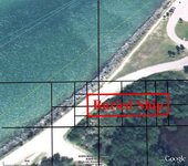
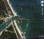
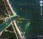
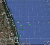
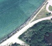
Since so many of the photos, that get posted in this board, usually have mostly land in them. Here is a water photo, good practice for both beginners and experienced dowsers. The quality of most beaches in GE is very excellent also...allows you to zoom in close while visible details remain clear.

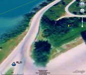
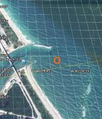
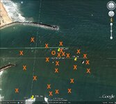
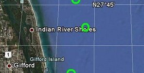
Edit Update: Follow on down the thread to the last couple photos. Stronger, more significant search signal locations are found S of the original search area, off shore and not in so close.
 

Attachments

  • shallow_water1.jpg
    shallow_water1.jpg
    93.9 KB · Views: 1,264

aarthrj3811

Gold Member
Apr 1, 2004
9,256
1,169
Northern Nevada
Detector(s) used
Dowsing Rods and a Ranger Tell Examiner
Re: Shallow water practice photo

Silver Wedding Ring...Buried under 1 foot deep..
 

Attachments

  • shallow_water1.jpg
    shallow_water1.jpg
    28.9 KB · Views: 1,020
OP
OP
Red_desert

Red_desert

Gold Member
Feb 21, 2008
6,844
3,494
Midwest USA
Detector(s) used
Garrett Ace 250/GTA 1,000; Fisher Gold Bug-2; Gemini-3; Unique Design L-Rods
Primary Interest:
All Treasure Hunting
Re: Shallow water practice photo

That's a good start at it, Art. Yes, I checked your arrow with my rods and got a signal there. Found a few more signals left of the arrow in the sand, some in the water off the same sand point. Don't be afraid to mark anything.

I'm adding another photo of the area, to continue right below it.
 

Attachments

  • shallow_water2.jpg
    shallow_water2.jpg
    92.7 KB · Views: 927

aarthrj3811

Gold Member
Apr 1, 2004
9,256
1,169
Northern Nevada
Detector(s) used
Dowsing Rods and a Ranger Tell Examiner
Re: Shallow water practice photo

6 inches deep
 

Attachments

  • shallow_water2.jpg
    shallow_water2.jpg
    33.7 KB · Views: 831
OP
OP
Red_desert

Red_desert

Gold Member
Feb 21, 2008
6,844
3,494
Midwest USA
Detector(s) used
Garrett Ace 250/GTA 1,000; Fisher Gold Bug-2; Gemini-3; Unique Design L-Rods
Primary Interest:
All Treasure Hunting
Re: Shallow water practice photo

aarthrj3811 said:
6 inches deep

Yeah!!!!! :headbang: :hello2: :thumbsup: 
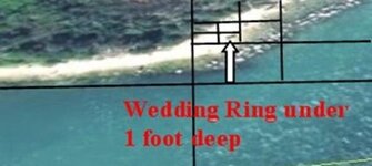
I knew you could do it Art....this is what I was waiting for. :laughing9:

I have a dowsed photo also, but should wait on whoever else would like to give a try. Here is a big clue...there is 1715 Fleet shipwreck treasure in these photos.
 

aarthrj3811

Gold Member
Apr 1, 2004
9,256
1,169
Northern Nevada
Detector(s) used
Dowsing Rods and a Ranger Tell Examiner
Re: Shallow water practice photo

Hey Red_desert…Thank you. I learn something new every day. I had ask if their were any sunken ships in the water. I had forgotten about the power of storms.
Back in the 50’s I was called out to help recover an 18 ton Coast Guard Buoy that was on a beach. You could clearly see where this buoy had hit the cliffs about 200 feet above the beach.

I also have tried using the rods to locate objects on maps…It works but I was having trouble marking spots and found that using a Pendulum worked better for me…

I found a buried ship with no treasure…Art
 

Attachments

  • shallow_water2.jpg
    shallow_water2.jpg
    105.5 KB · Views: 792
  • shallow_water2.jpg
    shallow_water2.jpg
    105.5 KB · Views: 835
OP
OP
Red_desert

Red_desert

Gold Member
Feb 21, 2008
6,844
3,494
Midwest USA
Detector(s) used
Garrett Ace 250/GTA 1,000; Fisher Gold Bug-2; Gemini-3; Unique Design L-Rods
Primary Interest:
All Treasure Hunting
Re: Shallow water practice photo

I found a buried ship with no treasure…Art

Thanks Art, that just might clear up a mystery here. In one of the older threads, somewhere in the shipwreck board...a treasure hunter once believed he had found 1 of the 3 missing ships of the 1715 fleet. According to him it had been blown up on land and covered over with sand. The location was supposed to be on private land. He claimed to have used a magnetometer and dragged it over land at the spot which is on private land.

I'm thinking the ship was on a peninsula of land also. Back I'd tried finding it in Google maps, but searched in the area off to the right of these photos.

The only private land I find now, by searching in Google maps, is a peninsula of land. It starts at the bottom left of the photo you found the ship. Everything else is Florida state parks and state park recreation areas. Kind of interesting to me, Florida state parks could grab so much land...almost as if they believed something might be there worth keeping treasure hunters away from.

No treasure on this ship, sounds right to me. By dowsing, I've picked up a trail of treasure which goes beyond the left edge of these photos. The drift trail seems to go west a ways, then takes a turn back SE and hits the private land peninsula about 2/3 the distance before reaching the tip end. Divide the area into thirds, where the 2nd third ends, close to spot the drift trail hits land. The trail of treasure stops there....if a ship of the 1715 fleet is buried in sand, it is at this location.

So, the ship you found Art, probably isn't of the 1715 fleet and shouldn't have any treasure on it. Private lands start somewhere around the location you dowsed, not sure if it is on private or state park property. But, if it doesn't contain treasure, Florida state parks can claim that wreck for all I care.

Art, you might check again and see if it could be a part of a treasure galleon that broke off from the ship. Just in the water, above in the area you dowsed the boat and lower 1st photo...I found some gold artifacts plus other stuff like silver coins, etc.
 

OP
OP
Red_desert

Red_desert

Gold Member
Feb 21, 2008
6,844
3,494
Midwest USA
Detector(s) used
Garrett Ace 250/GTA 1,000; Fisher Gold Bug-2; Gemini-3; Unique Design L-Rods
Primary Interest:
All Treasure Hunting
Re: Shallow water practice photo

Ok Art, I checked that spot with my rods. I did get a response for ship. It was easy to follow the edges to get an outline of it's shape. The shape is more like a broken piece of a ship. I asked about galleon, got a yes, also for part of a galleon. When asking about other types of ships, no for all else. I think what treasure the ship piece held was all dumped in this area.

Check this photo...here is the end of treasure trail I mentioned earlier(above comment).
 

Attachments

  • shallow_water3.jpg
    shallow_water3.jpg
    73.4 KB · Views: 792

aarthrj3811

Gold Member
Apr 1, 2004
9,256
1,169
Northern Nevada
Detector(s) used
Dowsing Rods and a Ranger Tell Examiner
Re: Shallow water practice photo

There has to be ship parts all over the state.
 

Attachments

  • 5_Florida_for_web.jpg
    5_Florida_for_web.jpg
    77.2 KB · Views: 1,058
OP
OP
Red_desert

Red_desert

Gold Member
Feb 21, 2008
6,844
3,494
Midwest USA
Detector(s) used
Garrett Ace 250/GTA 1,000; Fisher Gold Bug-2; Gemini-3; Unique Design L-Rods
Primary Interest:
All Treasure Hunting
Re: Shallow water practice photo

Florida has more than it's share of shipwrecks for sure. This is Sebastian Inlet, once a hurricane wrecked a couple galleons in and around it.
 

OP
OP
Red_desert

Red_desert

Gold Member
Feb 21, 2008
6,844
3,494
Midwest USA
Detector(s) used
Garrett Ace 250/GTA 1,000; Fisher Gold Bug-2; Gemini-3; Unique Design L-Rods
Primary Interest:
All Treasure Hunting
Re: Shallow water practice photo

The main reason for asking other dowsers to check Sebastian Inlet, was to see if a part or most of a ship got blown in there during a hurricane. We know some coins believed to be from a missing 1715 Fleet galleon have been recovered on shore N of the inlet entrance. In the 2010 salvage season, a search was made for this ship, even up river. Some artifacts were recovered, still disappointing though...some in the salvage business say the main part of the ship is deeper outside of the inlet.

I've been keeping back some of the dowsed photos, at least for outside of the entrance. I'm going to post them now. The red circle is where I found either a part of a ship or most of one. The Xs are debris and stuff from a shipwreck
 

Attachments

  • SB_2crop.jpg
    SB_2crop.jpg
    70.2 KB · Views: 794
  • SB_2a.jpg
    SB_2a.jpg
    176.4 KB · Views: 2,111
  • SB_2aX.jpg
    SB_2aX.jpg
    142.7 KB · Views: 5,181
OP
OP
Red_desert

Red_desert

Gold Member
Feb 21, 2008
6,844
3,494
Midwest USA
Detector(s) used
Garrett Ace 250/GTA 1,000; Fisher Gold Bug-2; Gemini-3; Unique Design L-Rods
Primary Interest:
All Treasure Hunting
Re: Shallow water practice photo

Here is the area from Vero Beach up N past Sebastian Inlet. About 2 years ago, was using a very small map with pendulum dowsing the whole 1715 Fleet location from Ft Pierce up N past Sebastian Inlet. I can remember my first and strongest signal coming from somewhere in the middle point, between the towns of Vero Beach and Sebastian. The town of Sebastian is S of Sebastian Inlet.

Whether this is the lost ship or just a treasure undiscovered from another wreck...it still seems to be a much stronger signal hit than around Sebastian Inlet or just a little S of the town Sebastian.

No hits are marked here by me, image is for dowsers to mark. I also noticed something new just now with posting this image. There is a shoal seen in the map called "Bethel Shoal" which could explain a wreck being farther out from shore, after hitting there and getting blown in closer some. Scattered ship debris could have then washed up around Sebastian.
 

Attachments

  • SB_area.jpg
    SB_area.jpg
    155.3 KB · Views: 912

Bill

Full Member
Mar 19, 2003
117
17
Cocoa Beach
Here is a small sample of wrecks we know about in this area. It would be impossible to dowse this area and NOT get hits. Using a magnetometer, we have many, many more hits that have as yet to be identified.

CAB CABIN 1715 81R23/S27 N27° 49.800 W80° 25.549

ANC ANCHOR WRECK 1715 81R46/S23 N27° 48.199 W80° 24.699

CAN CANNON WRECK* 1715+ 81R438/S23 N27° 48.202 N27° 47.45

GCB GREEN CABIN WRK*1618 81R22/S23 N27° 45.280 N27° 44.247

COR CORRIGANS WRECK 1715 81R19/S25 N27° 43.800 W80° 23.799

RIO RIO MAR WRECK 1715 81R27/S23 N27° 36.300 W80° 20.899

SPT SANDY POINT WRK 1715 81R20/S23 N27° 35.599 W80° 19.650

POW POWER PLANT WRK UNK. S25 N27° 21.199 W80° 13.650

DB DOUGLAS BEACH WRK 1715 8SL17/S26 N27° 25.299 W80° 16.500

UNK UNKNOWN WRK UNK. S23 N27° 18.999 W80° 12.300

*Cabin Wreck “N. Sra. De Regla” 1715
*Corrigans Wreck “San Roman” 1715
*Rio Mar Wreck “N. Sra del Carmen” 1715
*La Holandesa “La Holandesa” 1715
*Sandy Point Wreck “N. Sra. Del Rosario” 1715
*Wedge Wreck “Urca de Lima” 1715
*Colored Beach “Nieves” 1715
 

OP
OP
Red_desert

Red_desert

Gold Member
Feb 21, 2008
6,844
3,494
Midwest USA
Detector(s) used
Garrett Ace 250/GTA 1,000; Fisher Gold Bug-2; Gemini-3; Unique Design L-Rods
Primary Interest:
All Treasure Hunting
Yes, I realize the situation. The found shipwrecks technically are still recorded as unidentified, even though we believe the ship has been identified. When the ships of the 1715 Fleet wrecked, some split apart, one of them the crew on the top deck actually made it to shore...because the ship split, deck became like a surf board.

Drift trails may at points, have overlapped too...ships were all in sight of each other. Then galleons were meant to protect merchant ships when possible also.

There does seem to be a very strong signal in a spot off of Indian River Shores, I'm waiting to see what other dowsers get there.
 

OP
OP
Red_desert

Red_desert

Gold Member
Feb 21, 2008
6,844
3,494
Midwest USA
Detector(s) used
Garrett Ace 250/GTA 1,000; Fisher Gold Bug-2; Gemini-3; Unique Design L-Rods
Primary Interest:
All Treasure Hunting
Hey,
SPT SANDY POINT WRK 1715 81R20/S23 N27° 35.599 W80° 19.650

Sandy Point, I've seen comments in the shipwreck board suggesting those coins that were found there could be from the missing 1715 ship. Anyway, I'm not familiar with the actual locations of public records for these ships. It is hard to get an answer about where wreck sites can be found, from making posts in the shipwreck board. They feel it might encourage looters who don't have a permit.
 

teleprospector

Silver Member
Jul 8, 2007
3,786
4,132
The Motor City
🏆 Honorable Mentions:
25
Detector(s) used
Extended Sensory Perception, L-rod, Y-rod, pendulum, angle rods, wand.
White's MXT, Garrett Ultra GTA 500, AT Gold, SCUBA Detector Pro Headhunter, Tesoro Sidewinder, Stingray, 2 box-TF900, Fisher TW-6
Primary Interest:
All Treasure Hunting
Hi Red_desert,
My dowse revealed that the green rectangle areas contain scattered shipwreck remains.
White circles are gold and silver targets.
Green circles are combination gold/silver/emeralds.
Green dashed line was a signal that gave me a "smearing" type feel between the green circles.
The + above the green rectangle is a very strong signal that diminishes - in the direction of the arrow.
I did'nt dwell very long over your dowsing hits but did pick up on the signals you reported.
Thanks for posting your picture,
Jon
 

Attachments

  • SB_2aRDdowsed.jpg
    SB_2aRDdowsed.jpg
    174 KB · Views: 7,979

teleprospector

Silver Member
Jul 8, 2007
3,786
4,132
The Motor City
🏆 Honorable Mentions:
25
Detector(s) used
Extended Sensory Perception, L-rod, Y-rod, pendulum, angle rods, wand.
White's MXT, Garrett Ultra GTA 500, AT Gold, SCUBA Detector Pro Headhunter, Tesoro Sidewinder, Stingray, 2 box-TF900, Fisher TW-6
Primary Interest:
All Treasure Hunting
Hi Red_desert,
In this picture, my dowse revealed that in or in the vicinity of the green circles are shipwreck remains along with gold/silver/emeralds.
Thanks for posting your picture,
Jon
 

Attachments

  • SB_RDareadowsed.jpg
    SB_RDareadowsed.jpg
    155.6 KB · Views: 5,647
OP
OP
Red_desert

Red_desert

Gold Member
Feb 21, 2008
6,844
3,494
Midwest USA
Detector(s) used
Garrett Ace 250/GTA 1,000; Fisher Gold Bug-2; Gemini-3; Unique Design L-Rods
Primary Interest:
All Treasure Hunting
Great!!! Teleprospector, you nailed the one signal I mentioned, as being very strong...spot on, exact pinpoint. I dowsed it above and next to the "o" in "Indian River Shores". The signal I got seemed to contain emeralds, gold, silver too. Good work! I did get some scattered signals in the area above it, but strongest hit by the letter "o".

Your hits on the map with my previous hits earlier, show the ship remains S of the inlet, confirming some of my later hits not marked on the map. Once I moved out to dowse away from the inlet, seemed a ship may have wrecked further S and washed up toward Sebastian Inlet.
 

Attachments

  • SB_RDareadowsedcrop.jpg
    SB_RDareadowsedcrop.jpg
    21.2 KB · Views: 684

teleprospector

Silver Member
Jul 8, 2007
3,786
4,132
The Motor City
🏆 Honorable Mentions:
25
Detector(s) used
Extended Sensory Perception, L-rod, Y-rod, pendulum, angle rods, wand.
White's MXT, Garrett Ultra GTA 500, AT Gold, SCUBA Detector Pro Headhunter, Tesoro Sidewinder, Stingray, 2 box-TF900, Fisher TW-6
Primary Interest:
All Treasure Hunting
Hi Red_desert,
Thanks! It's great to see that our locations are similar. I'm hoping our dowses will be field checked.
This was the 2nd time I have dowsed for offshore objects and it's nice to get some feedback.
I feel there are lots of ships and treasure in this area and would love to follow up with another dowse whenever you want to recheck the area.
Jon
 

Top Member Reactions

Users who are viewing this thread

Top