Cochetopa
Jr. Member
- May 2, 2009
- 65
- 23
- Detector(s) used
- Minelab Eureka Gold
- Primary Interest:
- Prospecting
Hi, fellow dowsers,
During last winter, I started several map dowsing projects, the on-site results of which would be evaluated later after warmer weather arrived here in western Colorado. This narrative describes what happened on this year’s first outing during June.
As I have described in an old, previous TNet post, my interest is prospecting for minerals and my map dowsing technique is nothing exotic: an L-rod and paper maps laid out on a table. The maps are usually US Forest Service or USGS topographic 1:24,000 scale. The table is itself raised on a small platform, so an unfolded map is about at about my rib cage level. This arrangement works for me when triangulating a dowsing response.
Colorado spent 300+ million years of its history beneath oceans, seas and lakes accumulating thousands of feet of sediment. That material remains as sandstone rock all around where I live. However, there are places where the igneous and metamorphic basement rock beneath is visible. One of those locations is on the north end of the Uncompahgre Plateau. In that unconformity contact between sedimentary and igneous-metamorphic, I know others before me have found shallow mineralization. My interest for this project was residual placer gold occurrences. See https://en.wikipedia.org/wiki/Placer_mining and Types of Placers and Placer Deposits
I hoped I could identify any such occurrences on-site using my Minelab VLF metal detector in 60 kHz mode for max sensitivity to small particles of metal.
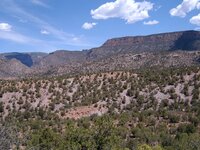
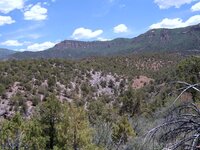
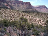
For this outing I drove my car to the Plateau and parked on the floor of Unaweep Canyon near Gateway, Colorado. I hiked up into canyon land terrain where the Plateau erodes downward from higher elevation. There you can see the color difference between gray-blue igneous and metamorphic material and orange-red sandstone.
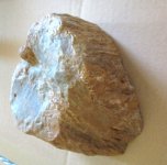
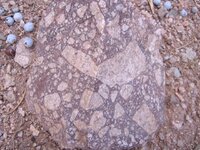
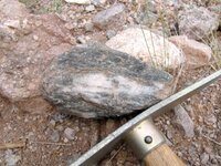
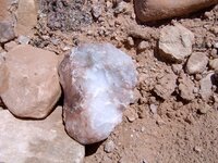
I found the geology changes fascinating as I gained elevation hiking up canyon ridges. I walked through igneous and metamorphic layers: quartzite, mica schist, schist with embedded quartz lenses, iron stained quartz, cryptocrystalline green quartz and breccia. I am strictly an amateur geologist. However, this type of geology told me there were favorable conditions beneath my feet for the type of gold mineralization I sought.
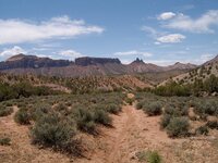
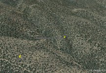
One of my problems that day was navigation in the canyon land maze of arroyos. Early on, I took a bad turn and followed the wrong arroyo. I planned to follow up a faint trail that followed the spine of a ridge directly east of my target location. Once opposite my destination on that ridge, I planned to descend cross-country into the canyon separating the two ridges and up the far side to arrive spot-on my target. In fact, I did reached the elevation I had wanted and one ridgeline east from where I wanted to be. But by that time, I was out of energy, and out of water, and the canyon between me and the next ridge over to the west was way too steep and deep, and the sun was beastly hot, and my feet hurt from new hiking boots that are too small, so I turned back for home. I might return in autumn when the weather is cooler, and if Google Earth plus my Garmin GPS can help me lay out a route to follow up the correct canyon ridgeline that belongs to my target location.
I have included several photographs with this posting. The name of each image describes its content. I’ve also attached a Google Earth screenshot of my target location. The “G7End” pushpin in the image is where I had to turn around and head for home.
Regards,
-C
p.s. My experience has been Google Earth views minimize the effect of elevation changes on surface topography. The separating canyon I described above is much deeper and with steeper sides when experienced on-site than how GE makes you think it is when viewed on a computer monitor in the comfort of your home. Or, could my impression simply be because I am no longer as young as I once was?
During last winter, I started several map dowsing projects, the on-site results of which would be evaluated later after warmer weather arrived here in western Colorado. This narrative describes what happened on this year’s first outing during June.
As I have described in an old, previous TNet post, my interest is prospecting for minerals and my map dowsing technique is nothing exotic: an L-rod and paper maps laid out on a table. The maps are usually US Forest Service or USGS topographic 1:24,000 scale. The table is itself raised on a small platform, so an unfolded map is about at about my rib cage level. This arrangement works for me when triangulating a dowsing response.
Colorado spent 300+ million years of its history beneath oceans, seas and lakes accumulating thousands of feet of sediment. That material remains as sandstone rock all around where I live. However, there are places where the igneous and metamorphic basement rock beneath is visible. One of those locations is on the north end of the Uncompahgre Plateau. In that unconformity contact between sedimentary and igneous-metamorphic, I know others before me have found shallow mineralization. My interest for this project was residual placer gold occurrences. See https://en.wikipedia.org/wiki/Placer_mining and Types of Placers and Placer Deposits
I hoped I could identify any such occurrences on-site using my Minelab VLF metal detector in 60 kHz mode for max sensitivity to small particles of metal.
For this outing I drove my car to the Plateau and parked on the floor of Unaweep Canyon near Gateway, Colorado. I hiked up into canyon land terrain where the Plateau erodes downward from higher elevation. There you can see the color difference between gray-blue igneous and metamorphic material and orange-red sandstone.
I found the geology changes fascinating as I gained elevation hiking up canyon ridges. I walked through igneous and metamorphic layers: quartzite, mica schist, schist with embedded quartz lenses, iron stained quartz, cryptocrystalline green quartz and breccia. I am strictly an amateur geologist. However, this type of geology told me there were favorable conditions beneath my feet for the type of gold mineralization I sought.
One of my problems that day was navigation in the canyon land maze of arroyos. Early on, I took a bad turn and followed the wrong arroyo. I planned to follow up a faint trail that followed the spine of a ridge directly east of my target location. Once opposite my destination on that ridge, I planned to descend cross-country into the canyon separating the two ridges and up the far side to arrive spot-on my target. In fact, I did reached the elevation I had wanted and one ridgeline east from where I wanted to be. But by that time, I was out of energy, and out of water, and the canyon between me and the next ridge over to the west was way too steep and deep, and the sun was beastly hot, and my feet hurt from new hiking boots that are too small, so I turned back for home. I might return in autumn when the weather is cooler, and if Google Earth plus my Garmin GPS can help me lay out a route to follow up the correct canyon ridgeline that belongs to my target location.
I have included several photographs with this posting. The name of each image describes its content. I’ve also attached a Google Earth screenshot of my target location. The “G7End” pushpin in the image is where I had to turn around and head for home.
Regards,
-C
p.s. My experience has been Google Earth views minimize the effect of elevation changes on surface topography. The separating canyon I described above is much deeper and with steeper sides when experienced on-site than how GE makes you think it is when viewed on a computer monitor in the comfort of your home. Or, could my impression simply be because I am no longer as young as I once was?


Attachments
-
 Breccia.JPG216.7 KB · Views: 110
 -
 QuartzInSchist.JPG210.8 KB · Views: 94
 -
 QuartzIronStained.JPG230.4 KB · Views: 106
 -
 UnconformityContactExposures1.JPG216.9 KB · Views: 95
 -
 UnconformityContactExposures2.JPG217.7 KB · Views: 95
 -
 ShortSectionOfNiceTrail.JPG204.5 KB · Views: 93
 -
 AerialViewGoogleEarth.JPG310.3 KB · Views: 94
 -
 IntendedDestinationRidgeline.JPG221.6 KB · Views: 89