Map dowsing request

KCW

Newbie
Nov 30, 2014
3
0
Primary Interest:
All Treasure Hunting
I am new here and this is my first post. I have dowsed for water with L rods since the 1980's. I learned this from my Dad as a way to locate water lines on construction sites. It was always easy to find a coat hanger or strip off some welders rod bend them up to make L rods. you always get guys pointing and laughing at you until I tell them where to dig and they find the water lines or broken pipe. Anyway I have since retired from construction and would like to try my L rods on something besides water.
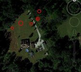
I would like hone my skills on my property and then venture to other areas. I've never heard of map dowsing but it does look very interesting. There's about 6" of snow on the ground so I don't think I can do much before spring but though I would learn as much as I can from this site over the winter.
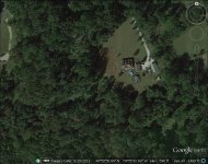
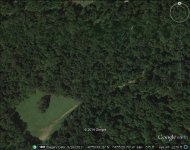
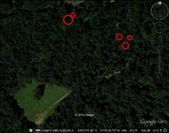
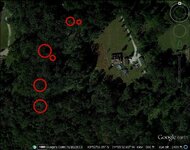
I seem to be having a problem getting google or mapquest pics of the property map onto this site. woulds it be possible to pm the address to some one to post photos of the map.
Thanks, Kirk
 

teleprospector

Silver Member
Jul 8, 2007
3,786
4,132
The Motor City
🏆 Honorable Mentions:
25
Detector(s) used
Extended Sensory Perception, L-rod, Y-rod, pendulum, angle rods, wand.
White's MXT, Garrett Ultra GTA 500, AT Gold, SCUBA Detector Pro Headhunter, Tesoro Sidewinder, Stingray, 2 box-TF900, Fisher TW-6
Primary Interest:
All Treasure Hunting
Hello,
Try google earth satellite images. You can save the image and post it on tnet.

From yahoo answers regarding saving satellite images from google maps and possibly mapquest as well:

The satellite images on Google maps are comprised of separate tiles arranged in a grid, so there's no single JPG file you could download that would match any specific view.

I would suggest using a screen capturing program such as FSCapture, or simply using the Print Screen button on the keyboard, then pasting into an image editor and cropping. On a Mac, use Command-Shift-4 to capture part of the screen. It gets saved to the Desktop as a PNG file by default, but can be converted to JPG using Preview or any other capable image app.


Jon
 

OP
OP
K

KCW

Newbie
Nov 30, 2014
3
0
Primary Interest:
All Treasure Hunting
Here are some maps.
 

Attachments

  • google earth witte lane.jpg
    google earth witte lane.jpg
    98.3 KB · Views: 112
  • google earth 2.jpg
    google earth 2.jpg
    91.9 KB · Views: 102

Red_desert

Gold Member
Feb 21, 2008
6,844
3,491
Midwest USA
Detector(s) used
Garrett Ace 250/GTA 1,000; Fisher Gold Bug-2; Gemini-3; Unique Design L-Rods
Primary Interest:
All Treasure Hunting
Check the red circle areas.
 

Attachments

  • GE_2-KCW.jpg
    GE_2-KCW.jpg
    105.7 KB · Views: 88
  • GE_wittelane-KCW.jpg
    GE_wittelane-KCW.jpg
    113.7 KB · Views: 102
  • GE_wittelane-KCW2.jpg
    GE_wittelane-KCW2.jpg
    61.1 KB · Views: 97
Last edited:
OP
OP
K

KCW

Newbie
Nov 30, 2014
3
0
Primary Interest:
All Treasure Hunting
The red circles are coin/treasure 1/2 feet down? Double red ring would mean a higher concentration of coin/treasure?
Thanks for the reply.

Kirk
 

Red_desert

Gold Member
Feb 21, 2008
6,844
3,491
Midwest USA
Detector(s) used
Garrett Ace 250/GTA 1,000; Fisher Gold Bug-2; Gemini-3; Unique Design L-Rods
Primary Interest:
All Treasure Hunting
The red circles are coin/treasure 1/2 feet down? Double red ring would mean a higher concentration of coin/treasure?
Thanks for the reply.

Kirk
I wasn't sure if it was a lost gold object (such as a ring) or gold colored like a brass buckle, button, etc. Put the little circle inside to identify the spot.
 

Top Member Reactions

Users who are viewing this thread

Top