Dowsing the Sierras

Hosssauce

Greenie
Aug 8, 2015
16
8
Primary Interest:
All Treasure Hunting
Howdy folks !

First off, Ive got to say that you guys are incredible ! It's fascinating the ability some of you possess and I have the utmost respect for this artform.

My first experience with dowsing was about a year ago when my neighbor was drilling a well and asked me if I wanted to come watch how it was done. I'm located in the Sierra Nevada's, Mariposa County specifically, and well drilling is a little bit different here. Rather than dig to a certain depth where you know the water table will be, out here it's kind of hit or miss, since you have to hit cracks in the bedrock and essentially hit an underground spring. So anyways I watched the well man do his magic. He grabbed his willow branch, not rods, and proceeded to walk his lines and spraypaint lots of indicators in the grass. He even gave them a "rough" estimate of the depth they'd need to dig to, and an approximate flow rate. And after spending about 40k on their well all on the whims of a willow branch, needless to say his rough estimates were not rough. They were basically exact. Anyways, from that moment on I was kind of in awe, and have since stumbled upon this amazing subforum !

Sorry for the longwinded opener :hello:

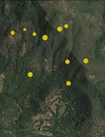
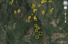
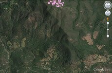
I have a picture that may be of interest if anyone wants to take a stab at it. This is on the east belt of the Motherlode in Mariposa County. About 75% of this is private property that is either in the family, or that I have access to via great neighbors. Also some BLM land. Thanks in advance !

Motherlode.jpg
 

Red_desert

Gold Member
Feb 21, 2008
6,850
3,500
Midwest USA
Detector(s) used
Garrett Ace 250/GTA 1,000; Fisher Gold Bug-2; Gemini-3; Unique Design L-Rods
Primary Interest:
All Treasure Hunting
Here is a starter.
 

Attachments

  • Motherlode-A- Hosssauce.jpg
    Motherlode-A- Hosssauce.jpg
    68.1 KB · Views: 84

aarthrj3811

Gold Member
Apr 1, 2004
9,256
1,169
Northern Nevada
Detector(s) used
Dowsing Rods and a Ranger Tell Examiner
No gold, silver or gem stones found. In California most of the gold has been found below 3200 feet elevations..Art
 

Red_desert

Gold Member
Feb 21, 2008
6,850
3,500
Midwest USA
Detector(s) used
Garrett Ace 250/GTA 1,000; Fisher Gold Bug-2; Gemini-3; Unique Design L-Rods
Primary Interest:
All Treasure Hunting
Places to check for native gold.
 

Attachments

  • Motherlode- Hosssauce.jpg
    Motherlode- Hosssauce.jpg
    145.4 KB · Views: 81

Red_desert

Gold Member
Feb 21, 2008
6,850
3,500
Midwest USA
Detector(s) used
Garrett Ace 250/GTA 1,000; Fisher Gold Bug-2; Gemini-3; Unique Design L-Rods
Primary Interest:
All Treasure Hunting
I'm getting some type of gemstone or crystal at the lilac boxes.
 

Attachments

  • Motherlode.jpg
    Motherlode.jpg
    137.5 KB · Views: 74
OP
OP
H

Hosssauce

Greenie
Aug 8, 2015
16
8
Primary Interest:
All Treasure Hunting
Thanks folks for the quick replies !

Aarthr - Funny you mention 3200ft, since the top middle of the map is the peak of a mountain that's around 3100. So you're tellin me there's a chance ! :occasion14:

Red - Thanks a ton. Very interesting seeing what you've come up with. For starters, as I mentioned those lilac boxes are on a pasture up on top of a peak. I've come upon many large open holes with trash in them, that I've always assumed were just that, trash holes. I'll definitely take a second look around there. Several of your other large clusters are very noteworthy spots that are either confirmed to have had past mining activity, or that I've seen strong indicators and have been wanting to take a closer look. Can't begin to thank you enough :hello2:
 

aarthrj3811

Gold Member
Apr 1, 2004
9,256
1,169
Northern Nevada
Detector(s) used
Dowsing Rods and a Ranger Tell Examiner
There is a book named The Tertiary gravels of the Sierra Nevada of California. It was printed in 1911. Every prospector in California should read this book...At
 

Red_desert

Gold Member
Feb 21, 2008
6,850
3,500
Midwest USA
Detector(s) used
Garrett Ace 250/GTA 1,000; Fisher Gold Bug-2; Gemini-3; Unique Design L-Rods
Primary Interest:
All Treasure Hunting
Thanks folks for the quick replies !

Aarthr - Funny you mention 3200ft, since the top middle of the map is the peak of a mountain that's around 3100. So you're tellin me there's a chance ! :occasion14:

Red - Thanks a ton. Very interesting seeing what you've come up with. For starters, as I mentioned those lilac boxes are on a pasture up on top of a peak. I've come upon many large open holes with trash in them, that I've always assumed were just that, trash holes. I'll definitely take a second look around there. Several of your other large clusters are very noteworthy spots that are either confirmed to have had past mining activity, or that I've seen strong indicators and have been wanting to take a closer look. Can't begin to thank you enough :hello2:
Sounds like an area where people have been hanging out a lot.....it might be that the gemstone hits were from gems on lost jewelry. You'll have to check it out though to make sure of what type. I know on the mid to top left of boxes (last ones made) got diamond hits.

Then again, I've seen old mining claims that could fit the description perfectly, trash everywhere because people didn't have access to metal detect it.
 

Last edited:

teleprospector

Silver Member
Jul 8, 2007
3,794
4,134
The Motor City
🏆 Honorable Mentions:
25
Detector(s) used
Extended Sensory Perception, L-rod, Y-rod, pendulum, angle rods, wand.
White's MXT, Garrett Ultra GTA 500, AT Gold, SCUBA Detector Pro Headhunter, Tesoro Sidewinder, Stingray, 2 box-TF900, Fisher TW-6
Primary Interest:
All Treasure Hunting
Howdy Hosssauce,
Dowsing revealed an attraction to gemstones in the white rectangle. Rough opals/petrified wood <5' deep
White diamonds: Native diamonds Loose concentration <15' deep
White triangles: Gold/silver bars and mine area. <60' concealed shaft/adit going into side of mountain.
Blue circle: Silver attraction. Possible bars, <10' deep
White circles: Native gold. Loose pockets spread out surface to 6' deep
Green circle: Placer gold. Surface to 3' deep, small pocket deposits.
Yellow X: Small amount of platinum. Small nuggets spread out.
White line: Precious metal vein, gold/silver combination.
Thx for posting your picture,
Jon
MotherlodeDowsed.jpg
 

Last edited:
OP
OP
H

Hosssauce

Greenie
Aug 8, 2015
16
8
Primary Interest:
All Treasure Hunting
There is a book named The Tertiary gravels of the Sierra Nevada of California. It was printed in 1911. Every prospector in California should read this book...At

Fantastic read aarthr ! I agree this is a must read for any California prospector !
 

OP
OP
H

Hosssauce

Greenie
Aug 8, 2015
16
8
Primary Interest:
All Treasure Hunting
Sounds like an area where people have been hanging out a lot.....it might be that the gemstone hits were from gems on lost jewelry. You'll have to check it out though to make sure of what type. I know on the mid to top left of boxes (last ones made) got diamond hits.

Then again, I've seen old mining claims that could fit the description perfectly, trash everywhere because people didn't have access to metal detect it.

Sounds like I need to go do some serious investigating up there ! :icon_thumleft: The property is currently a ranch that has been around since Day 1 of the town, and just off the edge of the picture on the backside of the hill, there are indeed 2 mines. Exploring in this area is kind of a nightmare though ! The chamise brush and manzanitas swallow you so hard it's insanely frustrating trying to walk through it ! Add ticks to that equation this time of year, and it's quite a brutal endeavor. Once I make a day of exploring, I'll be sharing some pictures of some of your more interesting areas that you've hit upon. Thanks again ! :occasion14:
 

OP
OP
H

Hosssauce

Greenie
Aug 8, 2015
16
8
Primary Interest:
All Treasure Hunting
Howdy Hosssauce,
Dowsing revealed an attraction to gemstones in the white rectangle.
White diamonds: Native diamonds
White triangles: Gold/silver bars and mine area.
Blue circle: Silver attraction.
White circles: Native gold.
Green circle: Placer gold.
Yellow X: Small amount of platinum.
White line: Precious metal vein, gold/silver combination.
Thx for posting your picture,
Jon
View attachment 1281635

Jon - Thank you so much for sharing this ! Wow a large gemstone hit in the exact spot as Red ! That is quite telling. Very, very interesting picture. Your vein that you've shown, specifically the top white circle location, is a specific spot I've been wondering about for awhile. It sits atop a large manzanita gnoll, just below the peak of the mountain. The top of the gnoll is nothing but large boulders and massive piles of rocks. So much so you can't even see earth in a lot of spots. Very out of place, and doesn't seem too indicative of the 49er days? The willow trees up there are the biggest and greenest around (As a side note about willows...specifically around here, it seems the only spot the willows grow are where the earth has been interupted....along roads and where lots of ground has moved from mining) Also, a few hundred feet down from this gnoll, in the adjacent gulley is a very old iron pipe the crosses the gulley about 10 feet in the air, and goes into the earth on both sides. I can't wait to go check this spot out again and show some pictures ! Another thing to note...just off the picture I showed, if you follow that vein you produced, is the exact location on the backside of the peak that I mentioned to Red is a patented mine site. That mine, and this manzanita gnoll, are at the EXACT same elevation. Makes me wonder if somehow these 2 sites are connected...

Your diamond, platinum, and silver hits are in very interesting locations as well. Work has been done in these spots in the distant past, and certainly worth another look now ! Your triangles have me quite intrigued as well. Too bad there's just about nothing worse than walking through THICK chamise and manzanitas though ! I'm not a claustrophobic person, but wow is that an awful experience lol. However once tick season dies down I'll be trailblazing and checking out each site you mentioned. Can't begin to thank you enough Jon !!

And of course, if I happen to find anything of great value, you two (Red an Jon) will definitely be receiving your fair share :hello2:

Happy hunting folks !
 

Red_desert

Gold Member
Feb 21, 2008
6,850
3,500
Midwest USA
Detector(s) used
Garrett Ace 250/GTA 1,000; Fisher Gold Bug-2; Gemini-3; Unique Design L-Rods
Primary Interest:
All Treasure Hunting
Sounds like I need to go do some serious investigating up there ! :icon_thumleft: The property is currently a ranch that has been around since Day 1 of the town, and just off the edge of the picture on the backside of the hill, there are indeed 2 mines. Exploring in this area is kind of a nightmare though ! The chamise brush and manzanitas swallow you so hard it's insanely frustrating trying to walk through it ! Add ticks to that equation this time of year, and it's quite a brutal endeavor. Once I make a day of exploring, I'll be sharing some pictures of some of your more interesting areas that you've hit upon. Thanks again ! :occasion14:
Thanks! :coffee2: I'd be interested in knowing what they were mining in those 2 mines.
 

teleprospector

Silver Member
Jul 8, 2007
3,794
4,134
The Motor City
🏆 Honorable Mentions:
25
Detector(s) used
Extended Sensory Perception, L-rod, Y-rod, pendulum, angle rods, wand.
White's MXT, Garrett Ultra GTA 500, AT Gold, SCUBA Detector Pro Headhunter, Tesoro Sidewinder, Stingray, 2 box-TF900, Fisher TW-6
Primary Interest:
All Treasure Hunting
Jon - Thank you so much for sharing this ! Wow a large gemstone hit in the exact spot as Red ! That is quite telling. Very, very interesting picture. Your vein that you've shown, specifically the top white circle location, is a specific spot I've been wondering about for awhile. It sits atop a large manzanita gnoll, just below the peak of the mountain. The top of the gnoll is nothing but large boulders and massive piles of rocks. So much so you can't even see earth in a lot of spots. Very out of place, and doesn't seem too indicative of the 49er days? The willow trees up there are the biggest and greenest around (As a side note about willows...specifically around here, it seems the only spot the willows grow are where the earth has been interupted....along roads and where lots of ground has moved from mining) Also, a few hundred feet down from this gnoll, in the adjacent gulley is a very old iron pipe the crosses the gulley about 10 feet in the air, and goes into the earth on both sides. I can't wait to go check this spot out again and show some pictures ! Another thing to note...just off the picture I showed, if you follow that vein you produced, is the exact location on the backside of the peak that I mentioned to Red is a patented mine site. That mine, and this manzanita gnoll, are at the EXACT same elevation. Makes me wonder if somehow these 2 sites are connected...

Your diamond, platinum, and silver hits are in very interesting locations as well. Work has been done in these spots in the distant past, and certainly worth another look now ! Your triangles have me quite intrigued as well. Too bad there's just about nothing worse than walking through THICK chamise and manzanitas though ! I'm not a claustrophobic person, but wow is that an awful experience lol. However once tick season dies down I'll be trailblazing and checking out each site you mentioned. Can't begin to thank you enough Jon !!

And of course, if I happen to find anything of great value, you two (Red an Jon) will definitely be receiving your fair share :hello2:

Happy hunting folks !

Hi Hosssauce,
You're welcome!
Thx for the feedback.
Have a safe search,
Jon
 

Red_desert

Gold Member
Feb 21, 2008
6,850
3,500
Midwest USA
Detector(s) used
Garrett Ace 250/GTA 1,000; Fisher Gold Bug-2; Gemini-3; Unique Design L-Rods
Primary Interest:
All Treasure Hunting
"adjacent gulley is a very old iron pipe the crosses the gulley about 10 feet in the air, and goes into the earth on both sides."

That's interesting! The reason it caught my attention, probably doesn't apply here, but in Europe a pipe going straight down into the ground could indicate a bunker. Recently, about 3-4 months ago, I was looking through the pics taken by people exploring an old Nazi bunker they had found. From the surface, the only visible clue was these pipes sticking up out of the ground and that must have been to get air down into the bunker. Of course, the ends on these pipes were curved, making them look more like an exhaust pipe of an automobile.
 

Last edited:

Top Member Reactions

Users who are viewing this thread

Top