Please help me locate the site of an old Spanish mission. It was built in 1717 and was abandoned in 1719. Thank you for your help.- Sabine
You are using an out of date browser. It may not display this or other websites correctly.
You should upgrade or use an alternative browser.
You should upgrade or use an alternative browser.
Spanish Mission Site
- Thread starter Sabine
- Start date


aarthrj3811
Gold Member
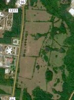
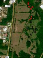
I would like to see a map of the next mile above this one

Last edited:

- Oct 26, 2004
- 24,101
- 22,873
- 🏆 Honorable Mentions:
- 2
- Detector(s) used
- Minelab Explorer
- Primary Interest:
- Shipwrecks
Welcome to TreasureNet !![FONT=crimson_textroman] Are you referring to the mission at Los Adaes founded by Domingo Ramon in[/FONT][FONT=crimson_textroman] 1717 but abandoned in 1719 when threatened by the French? If not, what is the name of the mission you seek?
Don.......[/FONT]
Don.......[/FONT]
- Oct 26, 2004
- 24,101
- 22,873
- 🏆 Honorable Mentions:
- 2
- Detector(s) used
- Minelab Explorer
- Primary Interest:
- Shipwrecks
Just found the location of your map site (thanks for the challenge); at the south east corner of West Columbus Street and State Route 96 in San Angustine, Texas.
Don.........
Don.........
okiedowser
Hero Member
check this area for mission,gold and sil
 ver target.
ver target.- Oct 26, 2004
- 24,101
- 22,873
- 🏆 Honorable Mentions:
- 2
- Detector(s) used
- Minelab Explorer
- Primary Interest:
- Shipwrecks
Can you answer my questions in post #3?
Since you know the exact location of the area, have you inquired in the local (town and county) libraries (reference department) for the answer; or you could seek out the local historian (through the reference desk at either the town or county library) and ask that person for assistance.
Don......
Since you know the exact location of the area, have you inquired in the local (town and county) libraries (reference department) for the answer; or you could seek out the local historian (through the reference desk at either the town or county library) and ask that person for assistance.
Don......
aarthrj3811
Gold Member
What is interesting to me is how much history is not recorded. I know of a place on highway 50 where there will be no record when the people that knew it are dead. It was a small store and bar. It has been gone for years. It was named Fred’s Place. It will always be Fred’s Place to me. I know of many more landmarks that have disappeared from history...Art
austin
Gold Member
Check with UT special collections and also the Texas Highway Dept. I had a publication from the two that traced El camino Real from Mission San Juan Bautista to the missions in East Texas. Joaquin ? was in charge. Gave all my papers to UT San Antonio last year and that was included. Cannot remember Joaquin's last name, but all mission sites have been found and identified. Joaquin McGraw, that's the guy. Thick book of maps and locations...
- Oct 26, 2004
- 24,101
- 22,873
- 🏆 Honorable Mentions:
- 2
- Detector(s) used
- Minelab Explorer
- Primary Interest:
- Shipwrecks
aarthrj3811
You mean this place?
Miler Marker 36
This is where Fred's Place was, the site of a resort and roadhouse after the curve east (closer to Tahoe) of the 5,000-foot elevation sign on Highway 50. Anna and Fred Scriggs opened the resort in 1918 on land leased from Eldorado National Forest. Fred's Place closed in 1965.
Don.....
aarthrj3811
Gold Member
I know it was on the highway near the entrance to Wrights Lake road
- Oct 26, 2004
- 24,101
- 22,873
- 🏆 Honorable Mentions:
- 2
- Detector(s) used
- Minelab Explorer
- Primary Interest:
- Shipwrecks
"From the Kyburz trailhead the trail heads east for 5.5 miles to reach the Wrights Lake Road. This section parallels the highway and sneaks through the Eagle Rock area of cabins, named for the mountain peak, visible at the 2 mile point, where eagles have been observed nesting. Another mile along, the trail intercepts a dirt road that leads down to “Fred’s Place,” once a road station, now just a memory. Then, after another mile and a half, the express trail brings you to Wright’s road (paved)."
Source: https://getoffyourgass.com/pony-express-trail/
Don......
Source: https://getoffyourgass.com/pony-express-trail/
Don......
aarthrj3811
Gold Member
One of times I was there we had towed a two wheel drive for many miles. We had went to the lake in the morning when the roads were froze. After it thawed it was real sloppy. The other truck could not get out so they bought us a beer when we got to Freds Place.
Red_desert
Gold Member
- Feb 21, 2008
- 6,846
- 3,500
- Detector(s) used
- Garrett Ace 250/GTA 1,000; Fisher Gold Bug-2; Gemini-3; Unique Design L-Rods
- Primary Interest:
- All Treasure Hunting
Red_desert
Gold Member
- Feb 21, 2008
- 6,846
- 3,500
- Detector(s) used
- Garrett Ace 250/GTA 1,000; Fisher Gold Bug-2; Gemini-3; Unique Design L-Rods
- Primary Interest:
- All Treasure Hunting
From my file of definitions.
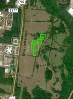
"Green line box (or solid filled circles) for various other targets, mostly archaeological such as old ruins or foundations but especially non-metallic objects like flint arrowheads, bottles, pottery, and carved stone markers."
"Green line box (or solid filled circles) for various other targets, mostly archaeological such as old ruins or foundations but especially non-metallic objects like flint arrowheads, bottles, pottery, and carved stone markers."
Attachments
- Oct 26, 2004
- 24,101
- 22,873
- 🏆 Honorable Mentions:
- 2
- Detector(s) used
- Minelab Explorer
- Primary Interest:
- Shipwrecks
Since the OP has not answered my Q in post 3, I'll move on to Art's comments about Fred's Place:
Fred's Place was built in 1918 by Anna and Fred Spriggs at the site of the historic Champlain House, above the 36 milestone. Their store, inn, restaurant and gas station also offered swimming in the cool waters of the pond near an early bridge over the creek. (Think of the metal detecting opportunity!!). Severely damaged by the creek's flooding in 1964, Fred's Place was dismantled. Improvements are still there, but today it is now a California Department of Transportation (Caltrans) storage area for sand and gravel.
Don....
- Oct 26, 2004
- 24,101
- 22,873
- 🏆 Honorable Mentions:
- 2
- Detector(s) used
- Minelab Explorer
- Primary Interest:
- Shipwrecks
Here's another clue:
[FONT=crimson_textroman]When Mission Dolores was reestablished in August 1722, Father [/FONT]Antonio Margil de Jesús[FONT=crimson_textroman] moved it one-fourth league east of the previous site; the new location was elevated and near a stream and a large tract of level land that could be used for cultivation. Recent research has located the site on a hill next to Ayish Bayou within the present city limits of San Augustine.
Don.......[/FONT]
- Oct 26, 2004
- 24,101
- 22,873
- 🏆 Honorable Mentions:
- 2
- Detector(s) used
- Minelab Explorer
- Primary Interest:
- Shipwrecks
Here's another clue: Dolores was a stop on the El Camino de los Tejas, and that trail is now the National Historic Trail of the same name. No doubt the staff at the National Trails Intermountain Region (1100 Old Santa Fe Trail, Santa Fe, New Mexico 87505 Phone: 505-988-6098 Fax: 505-986-5214) might be able to assist you further.
Don......
Don......
Top Member Reactions
-
 2404
2404 -
 1139
1139 -
 1118
1118 -
 899
899 -
 826
826 -
 804
804 -
 763
763 -
 733
733 -
 629
629 -
 515
515 -
 480
480 -
 468
468 -
 467
467 -
 428
428 -
 402
402 -
 398
398 -
O
369
-
 365
365 -
 359
359 -
 352
352
Users who are viewing this thread
Total: 2 (members: 0, guests: 2)