morbiusandneo
Sr. Member
- Jun 16, 2007
- 392
- 50
- Detector(s) used
- Dowsing rods
.png")
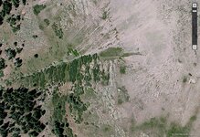
To the best of my understanding--the Spanish had many mines / placer mining --operations in the San Juan Mountains.
I believe the French were also here mining gold and silver.
My theory is that for a prospector today to make a gold or silver strike in the US--your best chance for a recovery
would be exploring / prospecting in the San Juan Mountains. I think that there are both lode and placer deposits yet
to be discovered as well as rich mineral deposits Worked by the Spanish as well as groups that came long before the
Spanish. Once when I was up in the San Juan Mountains I saw a number of Dragons from 30' to 200 ' tall. Could
they have been made by the Chinese centuries earlier? I have also seen Gorillas 300 feet tall--at the Black Canyon
of the Gunnison--and the Gorilla was wearing a belt and had a purse on his belt. I have no idea who made the Gorilla
but my hunch is it was here before the Pilgrims' landed at Plymouth Rock and even before Cortez reached Mexico City.
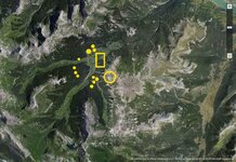
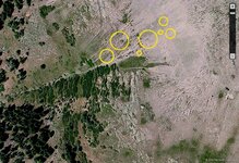
Barton sent me coordinates I think were south of the original gps. Anyway, if it was S of there, I marked only 1 yellow circle for shallow native gold, all the others for deeper or veins. I zoomed in to the circle area to make maps and then never checked them because Barton thought the yellow circle is the same location as Art found. I didn't check for any man made gold objects, only for shallow or deeper native gold. This location was east of the coordinates, probably on the bottom fringe of the map I'd already posted in the thread here. If you want me to, I'll check to see if the yellow circle is SE of Barton's original coordinates.View attachment 1359237
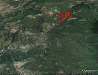
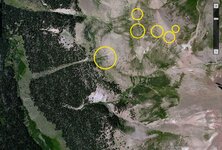
Greetings - able to pick up anything on this map? Related to Barton's original query, but about 40 miles southeast. Thanks in advance!
I would love to see any letters written by KVM as he was very perceptive and an excellent treasure hunter
Barton
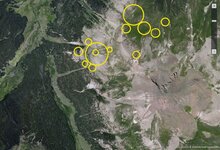
Yes, I found out checking, that the coordinates were up a ways from the 1st gps point you gave. My original red boxes were mostly up there anyway.Hello Red Desert,
If you are looking at your post #10 ( it has in Red #1, #2, #3 ) it shows an excellent view of UTE CREEK--the Middle Fork, the West Fork and the East Fork.
The GPS cordinates I gave were of the upper portion of the Middle Fork of Ute Creek where a cache of high grade ore was found. Your yellow circle was in this
photo #10 post in the East fork of Ute Creek. A little to the NE of where the cache was recovered.
It is my personal belief that there may be Spanish / French mines AND ore caches on the West, Middle and East branch's / forks of Ute Creek. My personal
belief is there was a lot more mining of gold and silver that is generally believed. When the Spanish were mining in the New World they were actually filling
up a Treasure Fleet of ships every year for shipment back to Spain. In just about every western state of the US and Mexico there are stories from the old days of
early Spanish mining. If one were to see or handle one of these old bars of Spanish gold or silver then you might have a unshakable belief that mining did in fact occur.
Many people go prospecting up on Ute Creek looking for the Spanish mine old stories speak of. My view is there was NOT one single mine--but several.
HardHatMatt--seems to have an interest in a cache site to the SE.
Barton
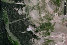
Here is an area, you might want to check out.My aerial photo is of the Upper Blanco River, south of Pagosa Springs. A deteriorated packsaddle filled with gold bars (and the skeleton of the mule carrying them) was found in this area in the mind 1900s...it is believed that this discovery may be related to the mine and cache(s) about which Barton has inquired. Apparently there was more than one mule lost in the Upper Blanco Basin on that occasion.