Dowsing locations

ozau21

Newbie
Jan 29, 2021
4
7
Brisbane
Primary Interest:
All Treasure Hunting
New member here and have read through many of the posts. I would like to post a picture from google earth and have it map dowsed as I have seen done on previous posts. A question I have is, is it helpful if for me to include the history of the site [as I have been told and researched] in the post.

Thank you.

View attachment ImageA.pdf

Hope I've got this right and the photo comes up.

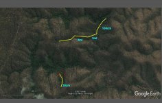
In the area of photo gold was found in the 1860's largest nugget was 18.5 DWT. Area allegedly worked by Chinese about 1900. Lone prospector there 1940-1950. Some small nuggets metal detected around 2010. Source of the gold never found and that is what I will be looking for. I briefly detected the part of the area 2014 found a coin dated 1865. Rugged terrain and dry creek beds. Retired now so it's time have a serious look.
 

Last edited:

weregolf

Hero Member
Jun 14, 2016
845
565
Mexico
Detector(s) used
Gemini III, Tesoro Lobo Supertraq, Fisher F2, Deepers 6, OKM rover C
Primary Interest:
Cache Hunting
Depth is aprox. for the gold veins (yellow lines), i dont know how wide are
Black circles are areas for nuggets
I will give it a try to red circle area :icon_thumleft:
 

Attachments

  • ozau21-locations.jpg
    ozau21-locations.jpg
    130.8 KB · Views: 103
OP
OP
O

ozau21

Newbie
Jan 29, 2021
4
7
Brisbane
Primary Interest:
All Treasure Hunting
Weregolf thank you for your response. The creek running west east above your 50cm line is what I call the west branch. The deeper reef area is what I call the north branch. I have not been to the north past the junction of the west branch. From what I have learned the most gold came from the west branch and south of the junction. Where the 2 gullies to the right or east of your 50cm line is where I found the coin in the creek. I walked the length or the west branch 25yrs ago and now recall an area that I think would be just above your red circle where there were pothole like diggings (about 120cm deep) and mounds, so this area looks good to revisit. I will be on site 20&21 March to reconnect and search. The deeper reef I will leave until June/July, our winter as I don,t have vehicle access into that area and it will be cooler for exploring and the snakes will be scarce. Thank you again and will report my findings to you.
 

Red_desert

Gold Member
Feb 21, 2008
6,844
3,494
Midwest USA
Detector(s) used
Garrett Ace 250/GTA 1,000; Fisher Gold Bug-2; Gemini-3; Unique Design L-Rods
Primary Interest:
All Treasure Hunting
Check these areas along weregolf's line.

ozau21-locations-G.jpg
 

Last edited:

Red_desert

Gold Member
Feb 21, 2008
6,844
3,494
Midwest USA
Detector(s) used
Garrett Ace 250/GTA 1,000; Fisher Gold Bug-2; Gemini-3; Unique Design L-Rods
Primary Interest:
All Treasure Hunting
Try this instead.

Image1.jpg
 

Red_desert

Gold Member
Feb 21, 2008
6,844
3,494
Midwest USA
Detector(s) used
Garrett Ace 250/GTA 1,000; Fisher Gold Bug-2; Gemini-3; Unique Design L-Rods
Primary Interest:
All Treasure Hunting
Last search was more focused on gold which is in quartz.
 

OP
OP
O

ozau21

Newbie
Jan 29, 2021
4
7
Brisbane
Primary Interest:
All Treasure Hunting
Red Desert thank you. I got within a mile from the location on 20,21 March, had flooding rain here and had to turn back. Will advise you and Weregolf when I head up there again.
 

Red_desert

Gold Member
Feb 21, 2008
6,844
3,494
Midwest USA
Detector(s) used
Garrett Ace 250/GTA 1,000; Fisher Gold Bug-2; Gemini-3; Unique Design L-Rods
Primary Interest:
All Treasure Hunting
Flooding... maybe it will wash up some gold. I'm thinking of perhaps a site search for old workings, could benefit some.
 

Last edited:

Red_desert

Gold Member
Feb 21, 2008
6,844
3,494
Midwest USA
Detector(s) used
Garrett Ace 250/GTA 1,000; Fisher Gold Bug-2; Gemini-3; Unique Design L-Rods
Primary Interest:
All Treasure Hunting
I marked the archaeological sites. These might not be all related to mining, but some sure are no doubt.

ozau21-locations-Archeol.jpg
 

Red_desert

Gold Member
Feb 21, 2008
6,844
3,494
Midwest USA
Detector(s) used
Garrett Ace 250/GTA 1,000; Fisher Gold Bug-2; Gemini-3; Unique Design L-Rods
Primary Interest:
All Treasure Hunting
Did a check for placer gold more toward left half of map. Green circles are archaeological sites I'd already marked.

ozau21-locations-Archeol-G1.jpg
 

Last edited:

Red_desert

Gold Member
Feb 21, 2008
6,844
3,494
Midwest USA
Detector(s) used
Garrett Ace 250/GTA 1,000; Fisher Gold Bug-2; Gemini-3; Unique Design L-Rods
Primary Interest:
All Treasure Hunting
Combine locations from both placer searches (first was checking more on right half of map).
 

Top Member Reactions

Users who are viewing this thread

Top