
- May 9, 2012
- 22,393
- 70,703
- Primary Interest:
- Other
Money ..or power ...or worse ,both combined ; can have a very negative effect on ethics.
Sentinel? Why yes, however, they are not always referred to as such.
I'm Native American, but didn't know it until I reached my majority (21 years) because my family tried hard to blend in. As Houma, some of us can often pass as white (many of my Nation had green eyes when we were discovered by La Salle on the banks of Lake Pontchartrain back in the 1700's).
In my younger years I often hunted with an old Choctaw here in Arkansas. That was my firs experience with the bent trees ... but because I have a fear of heights (unusual for an NDN, but it's because of a fall from a 3 story building when I was 2 or 3 years old) I found those trees convenient to stand on while deer hunting. Got me off the ground, but not too high up.
Decades later, I learned why my friend didn't like me climbing on them. He never told me, but I learned about the trees from a couple of former members here. I learned more from a member of another forum, from a friend on the Cherokee mailing list and a few others. I did a lot of research, ran into a lot of roadblocks among my people. My elders said they knew nothing of the trees, and still stand by that statement.
As with some of the people mentioned above, I watch for these trees in my area. I do not touch them ... I watch. I observe. I've learned not to tell the whites because they will either destroy it to "find treasure" or cut it down because it is related to Native Americans.
Contrary to common belief among many treasure hunters, there is a difference between a "treasure tree" and a "thong tree" --- or Indian Trail Tree. The trees are living history, some are/were considered sacred (prayer trees in Colorado for example). There was a prayer tree near where I live. A forester who knew of these trees cut the tree just above the vertical bend as an insult. He left the rest of the tree.
I do watch the forums. I've learned even here not to say anything even when the tree is clearly not a "hoot owl tree".
I've even found a "Hoot Owl Tree" in an area frequented by John Morrell. Nothing there, but the tree is interesting to look at. I've even posted pics here. Another has a 3D bald eagle climbing the side of it. The head is even white. It came from how the bark was removed/treated/burned/reattached.
Do they mark treasure? Well, it depends on what you call treasure.
There is a group mapping " trail trees".
Have seen a photo of a nephew by one in the southern part of the state in a now ( of course) well developed area.
Nice to see some almost respectful interest ,documentation and non molestation for a change.
Mounds despite a unpleasant history involving many violated and even removed are seeing more protection too now.
I'm curious when near ( most understandably that are reasonably secure are on private land) but steer clear.
An old Sioux here in Mi ( folks travel )long ago told of a downstream site he used to sift/ screen , but I just go past .
The property owners in some cases could be considered sentinels . Those that care anyway. A bit farther south natives still care for one mound group.
Of related interest, an uncle used to locate and restore ( to a point) forgotten cemeteries.
May have been a pioneer one that dad mentioned hearing a slight chime noise from above.
On a high branch hung a feather balanced with a bead on the quills large end. ( I don't recall what made the note( s).
That place had natives and those who came after together.
So did tales of a harmony of sorts during a blip in history.
One farm that natives used the house floor for a nights rest when passing along the river ,and usually gone before light was up much.
Great grandfathers general store and the kegs of beads in the loft that grandma as a child would mix when having a naughty spell.
Beads turned up too in a sand blow not far away probably predating great grandfather.
No conflict with natives recorded ,unless the claim of their being an Indian in the wood pile is true. An uncle with high cheek bones was not well liked by grandfather and was farmed out young...
Somewhere is a picture of gramps in a little boys dress/ gown whatever they called them ,on the store porch with a pet deer.
How a deer was preserved at a time folks would pocket one in a heartbeat must have taken cooperation among all visitor's.
As far out beyond the nearest village as they were in that land of many small waterways , I don't imagine anything they did went un noticed.
But ,they were not there to molest others history , or what had been placed by others.
I believe that certain people check up on carvings, etc to insure that they are intact. They may even create new ones. These carvings, along with natural and manmade permanent landmarks, and in some cases, areas of terraforming (road cuts, ponds, tunnels, etc) form geometric patterns in areas where valuable caches may exist. If there is a cache nearby, then it's my opinion that it's secure and needs no "guarding" because its location - while possibly associated with the geometric patterns - is not decipherable from the pattern itself. These people also, in my opinion, are the same ones who reveal some of these clues to new people every generation or two, thus keeping the locations of the clues known at all times by at least a few folks. Why they do this, I don't know. If there was such a thing as the classic "sentinels" as we know the term, I think they have faded away, probably since the 1930s and certainly by the 1980s. When guys talk about encounters with "treasure sentinels", I believe they are mistaking these people with other folks who they might have run into on their sites - random crazed treasure hunters like themselves, or ranchers, landowners, marijuana growers, artifact hunters, etc.
Yes, I used to associate with the Mountain Stewards. Contributed to their "database" of trees. I put their head guy (Don Wells) in contact with Celinda Kaelin (with the Pike's Peak Historical Society. She has written articles about the Ute prayer trees as well as their medicine trees --- she was instrumental in saving them from being bulldozed) after she and I had talked about the similarities. Don't know what happened, but she won't talk to me anymore. Don Wells of the Mountain Stewards doesn't talk with me any more since I stopped sending in coordinates and other data on the trees I find and catalogue for my own records or the maps I personally ground truthed. ... but I do send him pictures of those trees he he!
The Mountain Stewards started out humble, then they became commercial ... oh the things people do (and how they change) for money.
I have a copy of a map that shows a "bent tree" labeled on an Indian trail that went through my town. Whoever made the map drew a small symbol of the tree that looked like the pictures that have been posted on the tnet forums.
That's an interesting story about your tribe. Releventchair and I have studied some about LaSalle. It seems some of the early explorers reported that the Mandan tribe, in the Dakotas, also had light colored eyes and hair.
I have never been able to understand how anybody could destroy something of historical value. When I see a sign or symbol that can be linked to another symbol, my imagination goes crazy, as many of you have witnessed. I want to know everything about the people who created the signs. It's sad, to me, to see these signs destroyed. I really don't care about any gold or silver, but I really do love the history.
It seems to me that I have read stories about tribes that guarded certain sites in remote areas. Now that's something I can understand and something that could present a sentinel threat. If a tribe knew of buried treasure, especially on tribal land, I can see where it would be in their interest to discourage people from hunting for it.


Sometimes these trees are close to and mark sacred sites. Others are like exit signs on the interstate. They don't mark a path, they mark where you get off the path.
Here are two exit signs along the Tcheminahaut Trail (fr. "Chemin a haut" english: High Path) in Louisiana:
Not sure what this exit is pointing to, but the single upright is directional.
This double upright points to the last night camp on the Theminahaut Trail from Arkansas Post to Ouachita Post. From that campground, it was a one day walk to Ouachita Post (now Monroe, LA). You can see the restriction marks on this tree ... the "thong marks". Some will come here and say "That tree isn't old enough because it's too small!" The next tree is documented to be 800 years old.
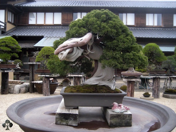
Similar process, only one is left in the wild the other lives in a pot. When you bind any living thing you restrict its growth. The only way to know the age for certain is to core it.
Many Native Americans believe in "protection by obscurity". In other words, don't mention it and people won't think about it. Unfortunately such thinking has allowed many to believe that any bent tree is hiding or related to treasure which is not true. By remaining silent, many trees have been destroyed in a search for riches. If someone had spoken up about why that tree was where it was and why it was made the way it was, it might have been spared.
As with the languages though, the meanings of many of the marks on the trees have been lost through non use.
Hey RC, when you mentioned the trail tree in the southern part of your state, it got me to wondering if it was close to what used to be called the Sauk Trail. That tree that I posted about, up above, would have been on a western extension of that trail. It would be interesting to be able to connect those trees to a specific trail. If I remember right, it seems to me that some of the earliest Copper Culture artifacts were found on that trail, somewhere close to Starved Rock in Illinois.
Ooooo you're going to get me fired up and head scratchin again...
If the tree points West , (and without knowing for sure I would still wager a doughnut ) with a Westish wind(which is common in fair weather) you could smell the big water. A mile or so away maybe.
At that water we know you go North or South. South leads to Saulk trail.(It must , it must.) There was a fort in the S.W. corner the community the tree is in shares the same name as. It was lost to time but had a replacement I think, North of old site.
If the water is followed North ,there is a bluff that pottery was made on for a long time and likely predating the fort. Going too far north ,though not ever untrammeled ,leads too far from the advantages to the South.
A kind of void midspan through there as far as any established long term occupation (far as I know)except for rivers and bays.
So ,the tree is suspected of pointing to the big water and the N.-S. (possible spur off the Saulk trail) along it and going S. , it would meet the Saulk trail. Or sure be headed towards it.
The tree could I suppose point S. to the Saulk trail ,but the advantage of running the plain/easy going along the water with it's visibility, sureness of course and of having water at hand would be lost. Once at that Southern end of water should be your trail junction. Also the tree being so far from that Saulk that only other signs connected would make it much help has me thinking(ya ,I know better)that it points West.
Tree could have simply indicated a campsite close too huh? l.o.l..
Winter meant heading inland up river valleys ,except much farther North near the Sault. (Not the Saulk.) Or across the water N.W. in the bay you are likely more familiar with.
That N.S. trail would not see the traffic year round as the more Southerly E.W. one of yours. Not far up is a snowbelt enhanced by lake effect that would make for lousy winter camps, let alone travel.
Here's a link of some of the old trails in Michigan. I seem to remember a map that shows a trail that follows, real close, the east side of Lake Michigan.
https://upload.wikimedia.org/wikipedia/commons/8/87/Michigan's_Indian_trails.png
Chadeaux says the trees could be used to tell you where to get off the trail, so maybe the tree is pointing to a junction and pointing the direction to go. Anything look familiar on the map?
Here's a link about a sacred site in Mississippi.
https://en.wikipedia.org/wiki/Nanih_Waiya
Have you ever heard of any bent trees close to this site? I've done some research on this place and I'm curious to know if there are any of the bent trees that point it out.
There are two things that I have seen that make me think that there is a modern sentinel at a cache site. One is an addition that was made to a major symbol that I believe was put there to confuse any hunters. The number 33 was also carved below this symbol a few weeks after I started studying this site. Another was a symbol that pointed directly to another symbol exactly 99 feet away. These two symbols were, without a doubt, related. They spelled the same 6 letter word except one symbol showed these letters in an abstract manner. The abstract letters were on a rock that broke off a cliff and were less than 14 years old. 14 years ago was when the rock broke off the cliff.
You've been treasure hunting for quite awhile, have you ever heard any sentinel stories from your treasure hunting friends?
I edited my previous post. The water is much closer than I had written.
The map you provided shows the " spur" I had suspected. It is the un named trail in the S.W. corner.
It does not show rivers but the next un named " spur"is a perfect sense to avoid that rolling cave roof of snow coming off the lake sometimes. To the North above where it meets the Grand River trail ( a long populated valley ,used heavy in winter ,but summer too)is near two rivers junction a studied site showed some very interesting ties to multiple nations/ tribes that were nearly duplicated ( or same as ) a site about midstate. Not related to the Grand River valley either it seems.
What is interesting is with the impact of conflicting groups , that other groups lithics show up from groups that were not established ; but in similar representative few numbers in the same square feet but roughly a weeks travel apart. ( The sites.) Those groups were not layered or by chance ,they were as one group.
Riverine corridors fill in some of the trail voids on your map. Other lessor ,though by no means faint at the time trails existed too of course.
Those couple sites though....The couple(?) studies I had on them from different sources are gone now.
Something really interesting went on at one time involving some serious travel ( from original groups " home turfs")and multiple groups represented ,at least by their lithics ; at the same time.
If represented in the flesh ,no other accounts reflect that . No suggestions as to why those not known to frequent those areas ever would .
No noted alliance or war allies ,or enemies.( Trade was my initial guess but did not seem to fit) No graves on either end and the southern location downstate a one sided palisade with earth against it and the much farther north an earth mound. The only no surprise commonality was both being near converging waters and having hearths and some presumed animal bone . ( A college group headed by a professor of archie doo poked the mound, and no human remains.) Other folks studied nearby mounds and nothing related to the earlier(and older) mound nearby was mentioned or the southern site so distant and different in structure no tie could be expected. But those mixed lithics disagree ,to me anyway. .....
One summer it would seem a couple thousand years ago or more fires burned and art ( not discarded )from multiple (more than a couple and less than a few,number forgotten now) cultures was left with them at separate events far apart ,in a very similar and deliberate manner near the same time. ( The same season or decade close enough for me) Both at confluences of waters ,though such sites were often used for many purposes.
Mayhaps I read too much into reading old accounts and then looking across rivers.
Someday maybe I'll look more at the sides I'm on ,but knowing where to look towards is enough. Any more than that would be imposing on another culture without an invite.
Anything displaced would be more lost when I get displaced , than where it is now......Where it is supposed to be.


