Here's a series of eight satellite images from Google Earth that documents the systematic destruction of a famous fossil leaf locality in the 12 to 10 million year-old middle to lower-late Miocene Mint Canyon Formation, Los Angeles County, California. A local geology professor had first brought the locality to the attention of the paleobotanical community in early 1971.
But, beginning sometime in either 2004 or 2005, construction activities eventually leveled (AKA, bulldozed) the area in preparation for the erection of a rather localized commercial district (in order to more efficiently serve the burgeoning population of the immediate vicinity, apparently).
The leaves occurred as brownish to black carbonized impressions in one of several whitish volcanic tuff beds interbedded in the dominantly fluviatile (stream-derived) to lacustrine (lake-deposited) Miocene Mint Canyon Formation.
Here's a list of the most common plants that could be recovered from the now obliterated locality:
Ceanothus precuneatus (buck-brush)
Ceanothus n. sp. (island-lilac)
Cercocarpus cuneatus (mountain-mahogany)
Crossosoma n. sp. (crossosoma)
Cupressus sp. (cypress)
Cyperacites n. sp. (Sedge Family)
Diospyros n. sp. (persimmon)
Fraxinus edensis (flowering ash)
Fremontia lobata (slippery-elm)
Lyonothamnus mohavensis (Catalina ironwood--Now grows in the wild only on the Channel Islands off the coast of Southern California)
Mahonia mohavensis (barberry)
Persea sp. (avocado)
Platanus paucidentata (sycamore)
Quercus convexa (oak)
Quercus dispersa (scrub oak)
Quercus lakevillensis (live oak)
Rhus sonorensis (evergreen sumach)
Robinia californica (black locust)
A sidelight here is that the late paleobotanist Daniel I. Axelrod first got wind of fossil leaves in the middle to late Miocene Mint Canyon Formation in the 1930s. As a matter of fact, on the morning of December 7, 1941, Axelrod just happened to be collecting from a Mint Canyon Formation locality (a site no longer accessible, by the way, having been swallowed up by real estate developments long ago); upon returning to civilization that day, he of course learned of the Pearl Harbor attack and immediately enlisted in the Army (at the age of 31), where he attained the rank of Major.
Here's the photographic series. All images from Google Earth. That yellow icon in roughly the center of each photo marks the precise position of the Mint Canyon Formation fossil site. For perspective, area in each photograph is 0.80 mile wide:

Image taken by satellite on August 23, 2002; first available color satellite picture for the region. For perspective, area in photograph is 0.80 mile wide. Yellow Google Earth map icon marks the exact position of the fossil leaf locality in the late middle to lower upper Miocene Mint Canyon Formation (approximately 12 to 10 million years old). Go here for a full-sized version of that same image: https://i.ibb.co/rf9bhw8/photo1-8-23-2002-1.jpg .

Image taken by satellite on April 21, 2003. Note lush native grasses on the hillsides. For perspective, area in photograph is 0.80 mile wide. Yellow Google Earth map icon marks the exact position of the fossil leaf locality in the late middle to lower upper Miocene Mint Canyon Formation (approximately 12 to 10 million years old). Go here for a full-sized version of that same image: https://i.ibb.co/qJSWrRb/photo2-4-21-2003-1.jpg .

Image taken by satellite on November 2, 2005. No Google Earth satellite imagery available for this region for all of 2004. For perspective, area in photograph is 0.80 mile wide. Yellow Google Earth map icon marks the exact position of the fossil leaf locality in the late middle to lower upper Miocene Mint Canyon Formation (approximately 12 to 10 million years old). Go here for a full sized version of that same image: https://i.ibb.co/89nSHF2/photo3-11-2-2005-1.jpg .

Image taken by satellite on March 15, 2006. For perspective, area in photograph is 0.80 mile wide. Yellow Google Earth map icon marks the exact position of the fossil leaf locality in the late middle to lower upper Miocene Mint Canyon Formation (approximately 12 to 10 million years old). Go here for a full-sized version of that same image: https://i.ibb.co/CPtqXpJ/photo4-3-15-2006-1.jpg .

Image taken by satellite on January 8, 2008. For perspective, area in photograph is 0.80 mile wide. Yellow Google Earth map icon marks the exact position of the fossil leaf locality in the late middle to lower upper Miocene Mint Canyon Formation (approximately 12 to 10 million years old). Go here for a full-sized version of that same image:
https://i.ibb.co/YZhcbqZ/photo5-1-8-2008-1.jpg

Image taken by satellite on May 24, 2009. For perspective, area in photograph is 0.80 mile wide. Yellow Google Earth map icon marks the exact position of where the fossil leaf locality once existed in the late middle to lower upper Miocene Mint Canyon Formation (approximately 12 to 10 million years old). Go here for a full-sized version of that same image: https://i.ibb.co/YLQ89G4/photo6-5-24-2009-1.jpg .

Image taken by satellite on October 28, 2011. For perspective, area in photograph is 0.80 mile wide. Yellow Google Earth map icon marks the exact position of where the fossil leaf locality once existed in the late middle to lower upper Miocene Mint Canyon Formation (approximately 12 to 10 million years old). Go here for a full-sized version of that same image: https://i.ibb.co/nLXJLj1/photo7-10-28-2011-1.jpg .

Image taken by satellite on July 27, 2017; as of 2019, the most recent photograph available. For perspective, area in photograph is 0.80 mile wide. Yellow Google Earth map icon marks the exact position of where the fossil leaf locality once existed in the late middle to lower upper Miocene Mint Canyon Formation (approximately 12 to 10 million years old). Go here for a full-sized version of that same image: https://i.ibb.co/2qQpfQ3/photo8-7-27-2017-1.jpg .
All Of My Fossils-Related (And Music) Pages On The Net
But, beginning sometime in either 2004 or 2005, construction activities eventually leveled (AKA, bulldozed) the area in preparation for the erection of a rather localized commercial district (in order to more efficiently serve the burgeoning population of the immediate vicinity, apparently).
The leaves occurred as brownish to black carbonized impressions in one of several whitish volcanic tuff beds interbedded in the dominantly fluviatile (stream-derived) to lacustrine (lake-deposited) Miocene Mint Canyon Formation.
Here's a list of the most common plants that could be recovered from the now obliterated locality:
Ceanothus precuneatus (buck-brush)
Ceanothus n. sp. (island-lilac)
Cercocarpus cuneatus (mountain-mahogany)
Crossosoma n. sp. (crossosoma)
Cupressus sp. (cypress)
Cyperacites n. sp. (Sedge Family)
Diospyros n. sp. (persimmon)
Fraxinus edensis (flowering ash)
Fremontia lobata (slippery-elm)
Lyonothamnus mohavensis (Catalina ironwood--Now grows in the wild only on the Channel Islands off the coast of Southern California)
Mahonia mohavensis (barberry)
Persea sp. (avocado)
Platanus paucidentata (sycamore)
Quercus convexa (oak)
Quercus dispersa (scrub oak)
Quercus lakevillensis (live oak)
Rhus sonorensis (evergreen sumach)
Robinia californica (black locust)
A sidelight here is that the late paleobotanist Daniel I. Axelrod first got wind of fossil leaves in the middle to late Miocene Mint Canyon Formation in the 1930s. As a matter of fact, on the morning of December 7, 1941, Axelrod just happened to be collecting from a Mint Canyon Formation locality (a site no longer accessible, by the way, having been swallowed up by real estate developments long ago); upon returning to civilization that day, he of course learned of the Pearl Harbor attack and immediately enlisted in the Army (at the age of 31), where he attained the rank of Major.
Here's the photographic series. All images from Google Earth. That yellow icon in roughly the center of each photo marks the precise position of the Mint Canyon Formation fossil site. For perspective, area in each photograph is 0.80 mile wide:
Image taken by satellite on August 23, 2002; first available color satellite picture for the region. For perspective, area in photograph is 0.80 mile wide. Yellow Google Earth map icon marks the exact position of the fossil leaf locality in the late middle to lower upper Miocene Mint Canyon Formation (approximately 12 to 10 million years old). Go here for a full-sized version of that same image: https://i.ibb.co/rf9bhw8/photo1-8-23-2002-1.jpg .
Image taken by satellite on April 21, 2003. Note lush native grasses on the hillsides. For perspective, area in photograph is 0.80 mile wide. Yellow Google Earth map icon marks the exact position of the fossil leaf locality in the late middle to lower upper Miocene Mint Canyon Formation (approximately 12 to 10 million years old). Go here for a full-sized version of that same image: https://i.ibb.co/qJSWrRb/photo2-4-21-2003-1.jpg .
Image taken by satellite on November 2, 2005. No Google Earth satellite imagery available for this region for all of 2004. For perspective, area in photograph is 0.80 mile wide. Yellow Google Earth map icon marks the exact position of the fossil leaf locality in the late middle to lower upper Miocene Mint Canyon Formation (approximately 12 to 10 million years old). Go here for a full sized version of that same image: https://i.ibb.co/89nSHF2/photo3-11-2-2005-1.jpg .
Image taken by satellite on March 15, 2006. For perspective, area in photograph is 0.80 mile wide. Yellow Google Earth map icon marks the exact position of the fossil leaf locality in the late middle to lower upper Miocene Mint Canyon Formation (approximately 12 to 10 million years old). Go here for a full-sized version of that same image: https://i.ibb.co/CPtqXpJ/photo4-3-15-2006-1.jpg .
Image taken by satellite on January 8, 2008. For perspective, area in photograph is 0.80 mile wide. Yellow Google Earth map icon marks the exact position of the fossil leaf locality in the late middle to lower upper Miocene Mint Canyon Formation (approximately 12 to 10 million years old). Go here for a full-sized version of that same image:
https://i.ibb.co/YZhcbqZ/photo5-1-8-2008-1.jpg
Image taken by satellite on May 24, 2009. For perspective, area in photograph is 0.80 mile wide. Yellow Google Earth map icon marks the exact position of where the fossil leaf locality once existed in the late middle to lower upper Miocene Mint Canyon Formation (approximately 12 to 10 million years old). Go here for a full-sized version of that same image: https://i.ibb.co/YLQ89G4/photo6-5-24-2009-1.jpg .
Image taken by satellite on October 28, 2011. For perspective, area in photograph is 0.80 mile wide. Yellow Google Earth map icon marks the exact position of where the fossil leaf locality once existed in the late middle to lower upper Miocene Mint Canyon Formation (approximately 12 to 10 million years old). Go here for a full-sized version of that same image: https://i.ibb.co/nLXJLj1/photo7-10-28-2011-1.jpg .
Image taken by satellite on July 27, 2017; as of 2019, the most recent photograph available. For perspective, area in photograph is 0.80 mile wide. Yellow Google Earth map icon marks the exact position of where the fossil leaf locality once existed in the late middle to lower upper Miocene Mint Canyon Formation (approximately 12 to 10 million years old). Go here for a full-sized version of that same image: https://i.ibb.co/2qQpfQ3/photo8-7-27-2017-1.jpg .
All Of My Fossils-Related (And Music) Pages On The Net
Amazon Forum Fav 👍


Attachments
-
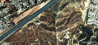 photo1-8-23-2002-1.jpg269.9 KB · Views: 43
 -
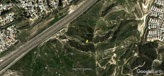 photo2-4-21-2003-1.jpg208.8 KB · Views: 63
 -
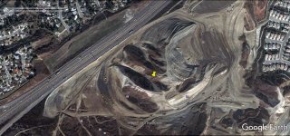 photo3-11-2-2005-1.jpg190.6 KB · Views: 47
 -
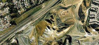 photo4-3-15-2006-1.jpg250.1 KB · Views: 45
 -
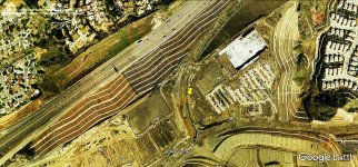 photo5-1-8-2008-1.jpg275.9 KB · Views: 76
 -
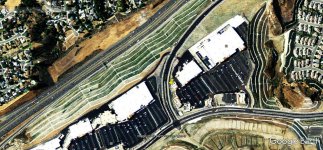 photo6-5-24-2009-1.jpg223.6 KB · Views: 51
 -
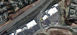 photo7-10-28-2011-1.jpg209.1 KB · Views: 48
 -
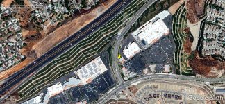 photo8-7-27-2017-1.jpg244.2 KB · Views: 58
Last edited:


