How to enter GPS coord into google maps?

rmptr

Silver Member
Dec 25, 2007
3,274
25
Tierra del Fuego
Detector(s) used
Tesoro.Fisher.Garrett
Thanks for looking!

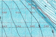
I went up the coast yesterday and took along my old Magellan GPS Pioneer.

It must be old technology, nowadays, because I had trouble locking on to 2 or three satellites.
Then they'd drop out...

Is this because of new technology implemented?

Next question...

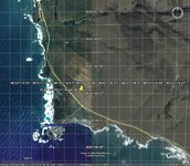
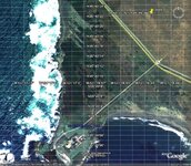
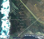
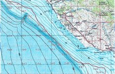
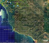
I DID get a fix, and wanted to post a trailhead, here on Tnet so others might be able to recover some jade at the location.
So I tried to type in the co-ordinates in google maps and can't seem to enter them in properly to get G maps to go to them with a satellite view.
It either won't accept what I type, or once, so far, has taken me off the coast of Korea in the China Sea!

(Whew! Don't anyone follow MY directions! ;D)

Can anyone tell me keystrokes to enter 35% 40' 22" N x 121% 16' 44" W into Google maps?

Thank you,
rmptr
 

OP
OP
rmptr

rmptr

Silver Member
Dec 25, 2007
3,274
25
Tierra del Fuego
Detector(s) used
Tesoro.Fisher.Garrett
Thanks Airforce,
I'll try it right now!

Did you see the cove and cliffs a couple hundred yards west of that cooordinate?

It's a neato place.

HH
rmptr
 

Red_desert

Gold Member
Feb 21, 2008
6,850
3,500
Midwest USA
Detector(s) used
Garrett Ace 250/GTA 1,000; Fisher Gold Bug-2; Gemini-3; Unique Design L-Rods
Primary Interest:
All Treasure Hunting
Take out the - from the coordinates.
It will look like this:
35 40' 22" N 121 16' 44" W
 

Attachments

  • jade1.jpg
    jade1.jpg
    128.1 KB · Views: 615
  • jade2.jpg
    jade2.jpg
    122 KB · Views: 542

Red_desert

Gold Member
Feb 21, 2008
6,850
3,500
Midwest USA
Detector(s) used
Garrett Ace 250/GTA 1,000; Fisher Gold Bug-2; Gemini-3; Unique Design L-Rods
Primary Interest:
All Treasure Hunting
Here is a little closer...
 

Attachments

  • jade3.jpg
    jade3.jpg
    165.2 KB · Views: 513

Red_desert

Gold Member
Feb 21, 2008
6,850
3,500
Midwest USA
Detector(s) used
Garrett Ace 250/GTA 1,000; Fisher Gold Bug-2; Gemini-3; Unique Design L-Rods
Primary Interest:
All Treasure Hunting
Or at Search TerraServer:
http://terraserver-usa.com/address.aspx

Put in as shown below

Longitude box: -121.1644
Latitude box: 35.4022


But in the search comes out like this

Longitude box: -121.15892
Latitude box: 35.40965


Here is the Topo and zoomed out a click each time. No aerial photos were available until at the 3rd Topo.Then only half of the area.
 

Attachments

  • jade4.jpg
    jade4.jpg
    101.2 KB · Views: 481
  • jade5.jpg
    jade5.jpg
    155.4 KB · Views: 488
  • jade6.jpg
    jade6.jpg
    133.2 KB · Views: 476

Red_desert

Gold Member
Feb 21, 2008
6,850
3,500
Midwest USA
Detector(s) used
Garrett Ace 250/GTA 1,000; Fisher Gold Bug-2; Gemini-3; Unique Design L-Rods
Primary Interest:
All Treasure Hunting
Road directions here...
 

Attachments

  • jade7.jpg
    jade7.jpg
    147.2 KB · Views: 510
OP
OP
rmptr

rmptr

Silver Member
Dec 25, 2007
3,274
25
Tierra del Fuego
Detector(s) used
Tesoro.Fisher.Garrett
Hey Thanks Red!

I got it to work, just now, once...

Discovered the coordinates were for the Lighthouse at Piedras Blancas, and tried to enter proper coordinates and it won't take them!

Crazy...

should be at... 35 54'82"N 121 28'10"W
I'll try again.

Thanks,
rmptr
 

OP
OP
rmptr

rmptr

Silver Member
Dec 25, 2007
3,274
25
Tierra del Fuego
Detector(s) used
Tesoro.Fisher.Garrett
This is what I get...


Results 1 - 10 of about 47 for 35 54' 82" N 121 28' 10" W
Categories: Motels & Hotels
A
Majon International

and this

Results 1 - 10 of about 47 for 35 54' 82"N 121 28' 10"W
Categories: Motels & Hotels

and I tried it with yet different spacing!

Results 1 - 10 of about 47 for 35 54' 82" N 121 28' 10" W
Categories: Motels & Hotels
A
Majon International

Must be a glitch in the matrix?

DO NOT follow me!

Thanks,
rmptr
 

Red_desert

Gold Member
Feb 21, 2008
6,850
3,500
Midwest USA
Detector(s) used
Garrett Ace 250/GTA 1,000; Fisher Gold Bug-2; Gemini-3; Unique Design L-Rods
Primary Interest:
All Treasure Hunting
I'll check into it...it may be your settings in Google Earth.
 

Red_desert

Gold Member
Feb 21, 2008
6,850
3,500
Midwest USA
Detector(s) used
Garrett Ace 250/GTA 1,000; Fisher Gold Bug-2; Gemini-3; Unique Design L-Rods
Primary Interest:
All Treasure Hunting
My Google Earth is a recent version I downloaded this year.

In options from the tools menu...

3D view tab---under Show Lat/Long-----
Select Degrees, Minutes, Seconds.

For Graphics mode I have selected
OpenGL (default)
Click apply settings, ok tabs


Now in the side panel of Google Earth where it says Search, Places, Layers
View: core

Check boxes roads, 3D Buildings, Borders and Labels, Traffic, Terrain, Places of interest, to get it like my posted Google Earth Maps. To get the grid lines of coordinates...click the view menu, select grid. Then to add a place mark, there is a button at the top left corner of map.
 

Red_desert

Gold Member
Feb 21, 2008
6,850
3,500
Midwest USA
Detector(s) used
Garrett Ace 250/GTA 1,000; Fisher Gold Bug-2; Gemini-3; Unique Design L-Rods
Primary Interest:
All Treasure Hunting
Doesn't seem to be taking me there either...Jade at the University of Minnesota?

Problem solved!

35 54'82"N 121 28'10"W

82 can't be, turns over after 59

It would have to be like this:

35 54'52"N 121 28'10"W
 

OP
OP
rmptr

rmptr

Silver Member
Dec 25, 2007
3,274
25
Tierra del Fuego
Detector(s) used
Tesoro.Fisher.Garrett
Hey Red,

OK, I got it to work!

First

I clicked on the satellite view.... instead of the maps view that comes up as default...

then I entered 35 40' 20" n 121 16' 40" w bang....

It actually came up with a bit different number, but somehow I think it went for something close?

above, there is only a single space between the digit groupings.

Thanks,
rmptr

..and I'll try it again...
 

Red_desert

Gold Member
Feb 21, 2008
6,850
3,500
Midwest USA
Detector(s) used
Garrett Ace 250/GTA 1,000; Fisher Gold Bug-2; Gemini-3; Unique Design L-Rods
Primary Interest:
All Treasure Hunting
I just edited my last post, there was an error in the coordinate number...look above.
 

OP
OP
rmptr

rmptr

Silver Member
Dec 25, 2007
3,274
25
Tierra del Fuego
Detector(s) used
Tesoro.Fisher.Garrett
Good sleuth work Red!

OK, here the proper coordinates...

+35° 54' 52.00", -121° 28' 10.00" well, this is what the result comes up with...

35 54' 52"n 121 28' 10"w is what I entered....


So, If you look a hundred yards south of that pinpoint, you shall see the wide spot along the PCH
and a few cars are parked there...
There is a stile over the fence, AND the fence section is now removed alongside the stile.

You can see the trail towards the cliff, then it branches south a tad...

There is kind of a washout spot, that may be traversed, going down the cliff.
Now you know where to find jade, in California... guaranteed!
X marks the spot!

By golly you would really want to bring a 100ft climbing rope for an assist!
I did NOT!

Had to send my kid down. ;D

Thanks Red!


.... if you enjoy doing the satellite sleuth stuff, I posted over in politics or everything else last night about a link on KSA where people are doing a LOT of assessment work based on satellite pics of oilfields in ME.

Whether you're into that, or not, it's interesting to see all the satellite work they've done with only what is easily accessible in the public domain...

HH
rmptr
 

Red_desert

Gold Member
Feb 21, 2008
6,850
3,500
Midwest USA
Detector(s) used
Garrett Ace 250/GTA 1,000; Fisher Gold Bug-2; Gemini-3; Unique Design L-Rods
Primary Interest:
All Treasure Hunting
Ok rmptr, I'll take a look at the Jade site and check out the link on KSA...when I get time. Got on here late tonight, glad you got things fixed on the coordinates. This thread ought to help anyone else who has problems with using coordinates in Google Earth. :thumbsup:
 

Top Member Reactions

Users who are viewing this thread

Latest Discussions

Top