deepskyal
Bronze Member
- Aug 17, 2007
- 1,926
- 61
- Detector(s) used
- White's Coinmaster 6000 Di Series 3, Minelab Eq 600
- Primary Interest:
- Metal Detecting
Okay....for you railroad buffs...or anyone else up on historical places....
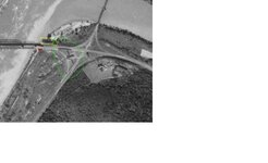
The area I have circled in green has me baffled. Looks more like some martian signage than a building complex...but the way this complex is set up...what purpose could it have served?
This area has history as far back as the settlers. It's become obvious that the area has morphed several times over the years.
The Kiskiminitis river flows into the Allegheny here. The area in the yellow is the remnants of the viaduct that once crossed the Allegheny River. The railroad bought all that property and filled in the old canal system.
The red dot shows where there is still a fire plug that dates to around 1920. Evidence is still there of telephone poles and possibly streetlighting. It's nonfunctional but still in place. This was a 4 way railroad intersection.
And why a fireplug here? Why next to a steel railroad trestle, at the top of a steep slope?
Back in the 1700's this was a popular place for Indians and settlers and soon became a town called Lucesco.
There was an oil refinery there that processed coal oil, there were mines, and company housing back in the mid 1800's.
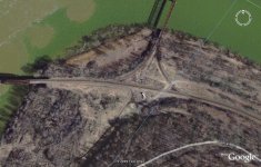
The structure circled in green is visable on a later photograph from the 1960's but is gone now. This photo is from 1938.
The central building has long extensions that go to long structures that parallel the railroad tracks.
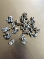
I've detected some areas here but it's tough going with the amount of slag and old railroad debris that has been bulldozed everywhere.
But not far from that structure, or rather where the structure used to be, is an area I found with the remnants of a nicely bricked walkway or road. We found a copper grounding rod still in the ground for a house or business.
The railroad is now only 3 way, but only the main track is used...the one that parallels the viaduct. The other trestle that crosses the kiski is unused but still obviously maintained but the tracks going inland have been torn out.
There are quite a few mysteries about the history of this area...what happened to the people, the houses, the businesses.....besides being bulldozed that is. There's no history written that I've been able to sift thru that speaks of the decline of the town or people. Nothing about the businesses folding and going away.
If you look at Google Eath images of the area today, there is nothing left except the railroad tracks. If you zoom in, you can barely make out the area where the brick paving has survived the years, although most is obscured by the vegatation.
So...any ideas on what this is/was?
Al
The area I have circled in green has me baffled. Looks more like some martian signage than a building complex...but the way this complex is set up...what purpose could it have served?
This area has history as far back as the settlers. It's become obvious that the area has morphed several times over the years.
The Kiskiminitis river flows into the Allegheny here. The area in the yellow is the remnants of the viaduct that once crossed the Allegheny River. The railroad bought all that property and filled in the old canal system.
The red dot shows where there is still a fire plug that dates to around 1920. Evidence is still there of telephone poles and possibly streetlighting. It's nonfunctional but still in place. This was a 4 way railroad intersection.
And why a fireplug here? Why next to a steel railroad trestle, at the top of a steep slope?
Back in the 1700's this was a popular place for Indians and settlers and soon became a town called Lucesco.
There was an oil refinery there that processed coal oil, there were mines, and company housing back in the mid 1800's.
The structure circled in green is visable on a later photograph from the 1960's but is gone now. This photo is from 1938.
The central building has long extensions that go to long structures that parallel the railroad tracks.
I've detected some areas here but it's tough going with the amount of slag and old railroad debris that has been bulldozed everywhere.
But not far from that structure, or rather where the structure used to be, is an area I found with the remnants of a nicely bricked walkway or road. We found a copper grounding rod still in the ground for a house or business.
The railroad is now only 3 way, but only the main track is used...the one that parallels the viaduct. The other trestle that crosses the kiski is unused but still obviously maintained but the tracks going inland have been torn out.
There are quite a few mysteries about the history of this area...what happened to the people, the houses, the businesses.....besides being bulldozed that is. There's no history written that I've been able to sift thru that speaks of the decline of the town or people. Nothing about the businesses folding and going away.
If you look at Google Eath images of the area today, there is nothing left except the railroad tracks. If you zoom in, you can barely make out the area where the brick paving has survived the years, although most is obscured by the vegatation.
So...any ideas on what this is/was?
Al