why do the members do this

OP
OP
M

metal mania

Hero Member
Jul 4, 2009
575
50
Primary Interest:
All Treasure Hunting
That can't be a 'serious question'... can it? basically, 'please post the good spots you worked hard to find so I can benefit by your work and take all the finds before you do.'

interesting!

and then the reply 'the Constitution is to make every man equal'.

I AM FOR THIS! We need to be EQUAL!... so.... here is what I need everyone to do... do this AS SOON as you finish reading this post! NO later!

#1. If you have a better detector than anyone here, please ship it to them, and let them know the time you spent on it so they can have EQUAL time swinging before shipping it back.
#2. Please do not just post your locations of the good hunting spots. Please also dig the treasure, as I work a lot, and can't get out as much as you to dig. Please divide it EQUALLY.
#3. If you do NOT have a good job or are wealthy, you need to find a second job so that you can pay my transportation to the good spots so we can have EQUAL time there.
#4. You may have a car with better gas mileage than mine. Please send me your miles-per-gallon so I can calculate the amout of money you owe me so to-and-from sites costs us the same and EQUAL.
#5. I need people in fair weather locations to stay in more and hunt less, because those of us in the snow belt can not get out as much as you, and that is not EQUAL time.
#6. If you have a job that allows you access to better locations than me, you need to either quit, to keep it EQUAL, or work part of mine so I can hunt your areas you have more often.
#7. Please send your IQ to me. You might be smarter than me and able to figure out complex detectors easier, so you will need to explain everything you know to me to keep our knowledge EQUAL.
#8. You will need to get in better shape through excercise or a diet. I work a lot and can't get out, so you have to hunt for both of us, without fatigue, so we can have EQUAL time at sites.
#9. If you are a Charter Member here, you need to buy my Charter membership, so we can be EQUAL here on the forums.
#10. Please send me the total time you spend researching hunt sites. I need you to either find more or better sites to keep the treasures EQUAL since you will be sharing them with everyone.

Thank you, and I think this will make metal detecting more EQUALLY enjoyable for everyone.

awe inspiring sarcasm I like it this rocks
 

TerryC

Gold Member
Jun 26, 2008
7,735
10,996
Yarnell, AZ
Detector(s) used
Ace 250 (2), Ace 300, Gold Bug 2, Tesoro Cortes, Garrett Sea Hunter, Whites TDI SL SE, Fisher Impulse 8, Minelab Monster 1000, Minelab CTX3030, Falcon MD20, Garrett Pro-pointer, Calvin Bunker digger.
Primary Interest:
Metal Detecting
You must have missed "Navigation 101"?

UTM stands for Universal Transverse Mercator.
Most people who only use coordinates on a small scale will use Degrees, Minutes, Seconds as their coordinates system.
People who use coordinates on a regular basis will use UTM over land because it is a direct measure over land.
Another reason to use UTM is you don't need to know if the map (in USA) is NAD83 (WGS84) or NAD27. Most US quads still are using the NAD27 format but WGS84 are starting to show up. AND I have even bought one recently with the UTM grid on them! TTC
 

Last edited:

Number9

Hero Member
Aug 3, 2009
872
768
Smoky Mountains
Detector(s) used
Minelab Sovereign GT
Another reason to use UTM is you don't need to know if the map (in USA) is NAD83 (WGS84) or NAD27. Most US quads still are using the NAD27 format but WGS84 are starting to show up. AND I have even bought one recently with the UTM grid on them! TTC

When using a GPS to help you navigate, always match the datum(NAD83, NAD27, etc) of the map to the GPS. If you don't the GPS may be off by a couple hundred yards.
Most, not all USGS topo maps have UTM ticks on the edges of the map.
Most Search & Rescue teams use the UTM coordinate system and most government maps(geological, etc.) use the same.

UTM is a very simple system to use! When you combine a good compass, topo maps or mapping software, with a GPS(with backup)...
you can navigate to any location in the USA to within feet... in any weather, day or night!
Just don't let your GPS be your only navigation tool... it may get you in trouble or lost!
 

TerryC

Gold Member
Jun 26, 2008
7,735
10,996
Yarnell, AZ
Detector(s) used
Ace 250 (2), Ace 300, Gold Bug 2, Tesoro Cortes, Garrett Sea Hunter, Whites TDI SL SE, Fisher Impulse 8, Minelab Monster 1000, Minelab CTX3030, Falcon MD20, Garrett Pro-pointer, Calvin Bunker digger.
Primary Interest:
Metal Detecting
When using a GPS to help you navigate, always match the datum(NAD83, NAD27, etc) of the map to the GPS. If you don't the GPS may be off by a couple hundred yards.
Most, not all USGS topo maps have UTM ticks on the edges of the map.
Most Search & Rescue teams use the UTM coordinate system and most government maps(geological, etc.) use the same.

UTM is a very simple system to use! When you combine a good compass, topo maps or mapping software, with a GPS(with backup)...
you can navigate to any location in the USA to within feet... in any weather, day or night!
Just don't let your GPS be your only navigation tool... it may get you in trouble or lost!
Maps are my PASSION! I have been collecting them since about 5 years old. I would empty my clothes drawer out to put cuttings of maps in it. I have been pushing UTM here for a few years. www.thecompassstore.com One of my favorite sites. I used to teach a compass/GPS class. A really nice $700 Brunton 5010GEO is part of my collection. Many people think throwing a compass and map in the pack is the answer. Well, if you don't know where you are BEFORE you need to know, it may be hard to figure it out when you NEED to know! GPS' help but as you alluded, the battery problem needs to be monitored. Tnx, 9, for starting me on my soapbox. I love to talk maps. I pencil in the UTM grid on all my maps. I then get the map laminated so I can use a Wet-erase pen on it. TTC
 

Last edited:

Number9

Hero Member
Aug 3, 2009
872
768
Smoky Mountains
Detector(s) used
Minelab Sovereign GT
I love maps too!
My first work with maps was just out of high school(1967). I worked for a civil engineering firm in Atlanta. My job was to update topo maps of Georgia for the USGS. This was before computers and all work was done with strip photos.
I have been researching old maps for gold and gem deposits for about 35 years now. Transferring old map info to current topos can take a long time!

I use Maptech Mapping Software and can print maps to any scale with the UTM overlay and any info or notes.

Most people who only use a GPS are really lost... but they don't know it!:laughing7:
Most will just hit the "go to" without really knowing where they are. You must know your current location to know where everything on your map is located!

I've been using a Brunton Pocket Transit for over 30 years... they do not lie!!

Best at ya!
Wayne
 

TerryC

Gold Member
Jun 26, 2008
7,735
10,996
Yarnell, AZ
Detector(s) used
Ace 250 (2), Ace 300, Gold Bug 2, Tesoro Cortes, Garrett Sea Hunter, Whites TDI SL SE, Fisher Impulse 8, Minelab Monster 1000, Minelab CTX3030, Falcon MD20, Garrett Pro-pointer, Calvin Bunker digger.
Primary Interest:
Metal Detecting
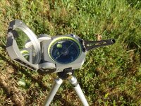
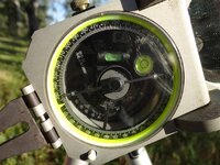
No disrespect meant to you but the USGS has been "dumbed down" in recent years. Four different sources of data and fewer field checks. I have found 4 bad data on the topo where my girlfriend is near Murphys, CA. My software of choice is TOPO 4. The replacement series ( meaning NM) would not let me open levels 4 and 5, getting me down to 1:24,000. I'm going to hold onto my TOPO 4 (2002) for as long as I can before switching. My 5010GEO sits on a tripod with the proprietory holder attached. Also has a true inclinometer w/scale built in. Life is good! TTC
 

Tnmountains

Super Moderator
Staff member
Jan 27, 2009
18,716
11,708
South East Tennessee on Ga, Ala line
🥇 Banner finds
1
Detector(s) used
Tesoro Conquistador freq shift
Fisher F75
Garrett AT-Pro
Garet carrot
Neodymium magnets
5' Probe
Primary Interest:
All Treasure Hunting
I used to use topo 4 or the versions before back when the old magellan colortack was out. Had a hard time getting it all to overlay properly that was with windows.Now I am on a Mac now but mostly study historical maps and atlases or the old USGS maps for home sites and roads. I do enjoy Google earth. You guys need to read how topography was invented in one of Bill Brysons books. Pretty comical. Kinda like this thread :tongue3:
 

Number9

Hero Member
Aug 3, 2009
872
768
Smoky Mountains
Detector(s) used
Minelab Sovereign GT
I cross check several maps before I plan a trip to a remote area.
I have found many faults with the USGS topos... and many others!
Always have a backup... I carry two GPS with extra batteries, two compass, and several maps of different scale of the area I'll be in.
 

TerryC

Gold Member
Jun 26, 2008
7,735
10,996
Yarnell, AZ
Detector(s) used
Ace 250 (2), Ace 300, Gold Bug 2, Tesoro Cortes, Garrett Sea Hunter, Whites TDI SL SE, Fisher Impulse 8, Minelab Monster 1000, Minelab CTX3030, Falcon MD20, Garrett Pro-pointer, Calvin Bunker digger.
Primary Interest:
Metal Detecting
I cross check several maps before I plan a trip to a remote area.
I have found many faults with the USGS topos... and many others!
Always have a backup... I carry two GPS with extra batteries, two compass, and several maps of different scale of the area I'll be in.
I have a few dozen compasses. 12 brunton instruction pack, the 5010, Silvas, etc. 3 Garmins, a Meggellan. I could go on but not my thread or about me. TTC
 

bigfoot1

Silver Member
Nov 1, 2011
3,765
3,399
so.cal.mtns.
🥇 Banner finds
1
🏆 Honorable Mentions:
1
Detector(s) used
garrett,minelab,fisher,,,atp current weapon of choice
Primary Interest:
Metal Detecting
we,the proud yeti people,have been sucessfully navigating while avoidin y'all for thousands of years.We use the UGH system.We get lost....ugh.We get seen...ugh.
So far pretty foolproof and no batteries required.And yes....we have high end detectors too.We call them,"oooohs"
 

Number9

Hero Member
Aug 3, 2009
872
768
Smoky Mountains
Detector(s) used
Minelab Sovereign GT
I have a few dozen compasses. 12 brunton instruction pack, the 5010, Silvas, etc. 3 Garmins, a Meggellan. I could go on but not my thread or about me. TTC

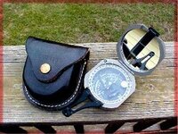
I have a few compass that I've pick up over the years. I have an 1917 U. S. compass and a U. S. 1943 Longines Wittnauer that's new in box with the small pouch.
But this is my "workhorse"...

compass.jpg

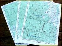
Here is some samples of the maps I print out. This is the same area printed in three different scales with UTM overlay on 8 1/2"X11" paper..

habmap3.jpg

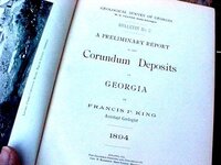
I like to collect old books on mining. The old map locations can be a real trick to convert to modern maps!
This is a rare book.. 1894 Corundum Deposits OF Georgia...

book2.jpg

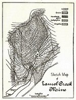
Map of Laurel Creek Corundum Mine - Rabun County, GA

laurelCk.jpg

Many maps that are over 100 years old are no very accurate and finding the locations is to combine the map with the written description.

But.. it's out there somewhere!

You may hear a banjo in this area!

"Warwoman" - Rabun County, Georgia

laurelmt.jpg
 

TerryC

Gold Member
Jun 26, 2008
7,735
10,996
Yarnell, AZ
Detector(s) used
Ace 250 (2), Ace 300, Gold Bug 2, Tesoro Cortes, Garrett Sea Hunter, Whites TDI SL SE, Fisher Impulse 8, Minelab Monster 1000, Minelab CTX3030, Falcon MD20, Garrett Pro-pointer, Calvin Bunker digger.
Primary Interest:
Metal Detecting
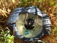
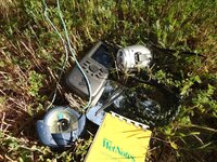
Here is my Brunton. With tripod and propriatory holder, more than $900 dollars! Too much to be made workhorse. It is set up as a compass and then as an inclinometer. The blue Plastimo goes in the field bag. It has a magnifying window that makes reading less than a degree possible without glasses.... I require this for emergency situations.... and accuracy. The rest are things that are always in the field bag. TTC

Brunton 5010GEO.jpg incline.jpg plastimo.jpg survival.jpg
 

Number9

Hero Member
Aug 3, 2009
872
768
Smoky Mountains
Detector(s) used
Minelab Sovereign GT
Now that's a very nice compass!!

It is a rare thing for me to sight compass bearings or use it for the triangulation of points for a location.
The main reason is limited sight. Unlike many locations in the West the Southern Appalachian Mountains don't offer a long view unless you're on a high peak. And being much older than the Rockies, the individual round tops of the range all look the same.
Most of the time when I'm looking for minerals or gold, I'm in heavy forest and sight distance most of the time is less than 100 yards.

Location check in the Nantahala National Forest...

3-20-10e.jpg
 

TerryC

Gold Member
Jun 26, 2008
7,735
10,996
Yarnell, AZ
Detector(s) used
Ace 250 (2), Ace 300, Gold Bug 2, Tesoro Cortes, Garrett Sea Hunter, Whites TDI SL SE, Fisher Impulse 8, Minelab Monster 1000, Minelab CTX3030, Falcon MD20, Garrett Pro-pointer, Calvin Bunker digger.
Primary Interest:
Metal Detecting
Yes, my BABY! But it ain't for usin'. It's for lookin' at! TTC
 

Top Member Reactions

Users who are viewing this thread

Top