Reading old property maps

OP
OP
MuckyBottles

MuckyBottles

Bronze Member
Jun 19, 2013
1,923
1,567
Stony Point, NY
Detector(s) used
Whites coin master gt..ace 250&350
Primary Interest:
All Treasure Hunting
Looking forward to seeing it.
Don...

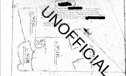
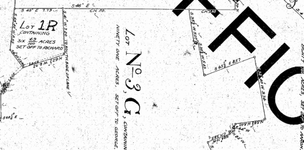
Here's the map, i have blocked out the name for obvious reasons. The map is dated by the archivist for 1901, but it appears the map states 1905.
full.png
close.png
 

OP
OP
MuckyBottles

MuckyBottles

Bronze Member
Jun 19, 2013
1,923
1,567
Stony Point, NY
Detector(s) used
Whites coin master gt..ace 250&350
Primary Interest:
All Treasure Hunting

GMD52

Silver Member
Feb 22, 2013
2,518
2,724
Lake Champlain, Vt.
Primary Interest:
All Treasure Hunting
If the Map contains any roadways that still exist today, It would be simple to figure the know distances from the map. One thing that you could do is get a copy of the recent tax map. overlay on the old one and align with any still existing road, river, or thoughfare. The distances measure should be accurate enough to find today....good luck....Gary
 

Tnmountains

Super Moderator
Staff member
Jan 27, 2009
18,716
11,705
South East Tennessee on Ga, Ala line
🥇 Banner finds
1
Detector(s) used
Tesoro Conquistador freq shift
Fisher F75
Garrett AT-Pro
Garet carrot
Neodymium magnets
5' Probe
Primary Interest:
All Treasure Hunting
I get my maps from an old forester. They show all the old roads and old long gone house sites. They are the topographical maps. I can post up a pic of one if you wish. I think what you have is a platt/survey map to a deed or parcel.
 

GMD52

Silver Member
Feb 22, 2013
2,518
2,724
Lake Champlain, Vt.
Primary Interest:
All Treasure Hunting
Us old forester's sure do know maps.....:laughing7:.....just retired after consulting for 40 years......Gary
As a post script.....most states and countys had Gazzeteers printed that showed the infrastructure, property lines, and major businesses.....this might , when put together with yours help in the cyphering.
 

OP
OP
MuckyBottles

MuckyBottles

Bronze Member
Jun 19, 2013
1,923
1,567
Stony Point, NY
Detector(s) used
Whites coin master gt..ace 250&350
Primary Interest:
All Treasure Hunting
I get my maps from an old forester. They show all the old roads and old long gone house sites. They are the topographical maps. I can post up a pic of one if you wish. I think what you have is a platt/survey map to a deed or parcel.

It can't hurt for you to post a topo. They in fact are a plot survey map, for a guy who's father was a commanding officer is the revolution/war of 1812.
 

Mackaydon

Gold Member
Oct 26, 2004
24,095
22,872
N. San Diego Pic of my 2 best 'finds'; son & g/son
🏆 Honorable Mentions:
2
Detector(s) used
Minelab Explorer
Primary Interest:
Shipwrecks
MuckyBottles,
I did some research. I'll PM you some history that you may already have. Meanwhile, I'll respect your choice not to disclose the name.
That family has rich history in the area.
No doubt if you took the map to the Planning Department in that town they could tell you exactly where that land is located.
And in the odd chance they can't help you, I'm sure your local historian (found through your library's Reference Desk) could help.
Don......
 

OP
OP
MuckyBottles

MuckyBottles

Bronze Member
Jun 19, 2013
1,923
1,567
Stony Point, NY
Detector(s) used
Whites coin master gt..ace 250&350
Primary Interest:
All Treasure Hunting
Thanks for help guys, much appreciated. Given that there is limited Sanborn maps for this given area, this is pretty much what I have to go on.
 

Top Member Reactions

Users who are viewing this thread

Top