GPS Coordinates Google Map Help

TSCOM

Jr. Member
Oct 13, 2014
62
27
Georgia
Detector(s) used
Fisher F5, Tesoro Compadre
Primary Interest:
Metal Detecting
I'm confused on how map coordinates work, especially on Google Maps. I tried reading on it and it's confusing me even more so I need a laymen's explanation.

When I get the coordinates on Google Maps it says: 33.865554, -84.686643
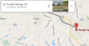
GPS 1.JPG

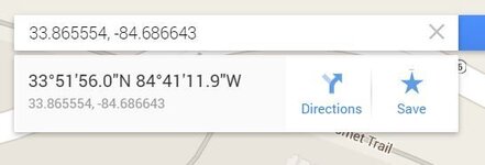
When I try to search for 33.865554, -84.68664, I get this:
GPS 2.JPG

They appear to be in two different formats. The later being in degree, mins, seconds. What's this format 33.865554, -84.686643?
 

AugustMoose87

Sr. Member
Sep 10, 2014
443
264
Longmont, CO
Detector(s) used
Gold Pan, Sluice, Hand Dredge, X-Terra 30, X-Terra 705, Sand Shark
Primary Interest:
All Treasure Hunting
The second format is just the decimal version. In other words, 0.865554 degrees is equal to 51'56.0" Both should take you to the exact same spot.
 

OP
OP
TSCOM

TSCOM

Jr. Member
Oct 13, 2014
62
27
Georgia
Detector(s) used
Fisher F5, Tesoro Compadre
Primary Interest:
Metal Detecting
The second format is just the decimal version. In other words, 0.865554 degrees is equal to 51'56.0" Both should take you to the exact same spot.

I thought that may be the case but it doesn't go to the same place. It's nearby but fairly off.
 

AugustMoose87

Sr. Member
Sep 10, 2014
443
264
Longmont, CO
Detector(s) used
Gold Pan, Sluice, Hand Dredge, X-Terra 30, X-Terra 705, Sand Shark
Primary Interest:
All Treasure Hunting
Interesting. The one thing that I have noticed using Google is that they have a tendency to try and put you on a road... So a lot of times when you enter coordinates that aren't on a road, they return with the coordinates of the point on a road that is closest to the coordinates entered.

I entered both 33.865554, -84.68664 and 33°51'56.0"N 84°41'11.9"W and was taken to the same spot - at least with in a few feet.


And reading further, I realized I skipped part of your question. Coordinates are based off the geometry of the earth. Latitude (north and south) are the easiest to understand. Picture the earth from space - it is a circle. Draw an imaginary horizontal line around the center of the circle - the equator. Now draw a vertical line going through the north and south poles. these two lines create a 90* angle at the center of the earth. This is where degrees come from. So any coordinates that are 0* are a spot on the equator, 90* north is the north pole, and 90* south is the south pole. 45* would be halfway between the equator and a pole (etc etc etc). Some sites/people use a positive value to represent north (rather than a N), and a negative value to represent south (rather than a S). Then each degree gets divided in to 60 minutes, and each minute is divided in to 60 seconds. It can be confusing, but these are not based of of the time units - they are angular units. If that is all as clear as mud, keep reading for longitude.

Longitude is a bit stranger. This time, look as the earth from space, but directly above the north pole. Now draw an imaginary line from the north pole to the south. This line is 0*. So a line 90* to the left of your line would be 90* west, and a line opposite yours would be 180* east OR west. This is where things get tricky... since there is no obvious spot to draw this line (like the equator for latitude). Most modern systems use the Greenwich Prime Meridian - an arbitrary line running from the north to south pole that goes through the Royal Observatory in Greenwich England. As any good treasure map reader should know, there are and were other meridians used, but that is another discussion. Again, the degrees are divided in the 60 minutes, and those are divided in to 60 seconds.

So if any of that doesn't make sense, speak up. I know it isn't the best job, but hopefully I have made things better rather than worse....
 

Number9

Hero Member
Aug 3, 2009
872
768
Smoky Mountains
Detector(s) used
Minelab Sovereign GT
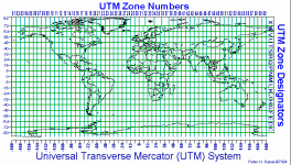
Best thing to start with is to use the UTM Coordinate System.. and not Degrees, Minutes, Seconds.
UTM is a direct measure over land.
 

OP
OP
TSCOM

TSCOM

Jr. Member
Oct 13, 2014
62
27
Georgia
Detector(s) used
Fisher F5, Tesoro Compadre
Primary Interest:
Metal Detecting
Interesting. The one thing that I have noticed using Google is that they have a tendency to try and put you on a road... So a lot of times when you enter coordinates that aren't on a road, they return with the coordinates of the point on a road that is closest to the coordinates entered.

I entered both 33.865554, -84.68664 and 33°51'56.0"N 84°41'11.9"W and was taken to the same spot - at least with in a few feet.


And reading further, I realized I skipped part of your question. Coordinates are based off the geometry of the earth. Latitude (north and south) are the easiest to understand. Picture the earth from space - it is a circle. Draw an imaginary horizontal line around the center of the circle - the equator. Now draw a vertical line going through the north and south poles. these two lines create a 90* angle at the center of the earth. This is where degrees come from. So any coordinates that are 0* are a spot on the equator, 90* north is the north pole, and 90* south is the south pole. 45* would be halfway between the equator and a pole (etc etc etc). Some sites/people use a positive value to represent north (rather than a N), and a negative value to represent south (rather than a S). Then each degree gets divided in to 60 minutes, and each minute is divided in to 60 seconds. It can be confusing, but these are not based of of the time units - they are angular units. If that is all as clear as mud, keep reading for longitude.

Longitude is a bit stranger. This time, look as the earth from space, but directly above the north pole. Now draw an imaginary line from the north pole to the south. This line is 0*. So a line 90* to the left of your line would be 90* west, and a line opposite yours would be 180* east OR west. This is where things get tricky... since there is no obvious spot to draw this line (like the equator for latitude). Most modern systems use the Greenwich Prime Meridian - an arbitrary line running from the north to south pole that goes through the Royal Observatory in Greenwich England. As any good treasure map reader should know, there are and were other meridians used, but that is another discussion. Again, the degrees are divided in the 60 minutes, and those are divided in to 60 seconds.

So if any of that doesn't make sense, speak up. I know it isn't the best job, but hopefully I have made things better rather than worse....

Thank you for taking the time to explain that. It makes as much sense as it can to me ;)
 

Frankn

Gold Member
Mar 21, 2010
8,711
2,989
Maryland
Detector(s) used
XLT , surfmaster PI , HAYS 2Box , VIBRA-TECTOR
I think it would have been far better if the longitude were set up like the latitude lines , but perpendicular to them. Yea they still could have used Greenwich to start but you would have wound up with "square" areas which would have been far easier to deal width. Frank five star.png
 

Number9

Hero Member
Aug 3, 2009
872
768
Smoky Mountains
Detector(s) used
Minelab Sovereign GT
The north and south polar regions—those areas above 84 degrees north latitude and below 80 degrees south latitude, respectively—are not included in the UTM coordinate system due to extreme projection distortions in the UTM grid as compared to the meridians of longitude.

Instead, these two polar regions are covered by the Universal Polar Stereographic, or UPS, coordinate system.

We're not going there anyway.. are we!?
 

Top Member Reactions

Users who are viewing this thread

Top