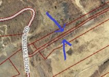
How do you find information about a potential house and road that no longer exist?

jolteon

Hero Member
Feb 22, 2014
621
248
Hey guys I had a quick question for you today. I’ve been using a website actually pointed out to me a few years ago on this website called historical Ariel’s. Historical Ariel’s if you do not know let’s you look at old Ariel and topi maps. I’ve located two homes in the woods near were I live that no longer stand. Without this technology I may have not found them. Recently I have found a old home and road on several maps that go back to 1869-1947. If a road no longer becomes a legal road is there a way I can find a record of that road existing. Does that exist? The land is now owned by that state so I assume there would be records that say it’s no longer a public road. I haven’t been able to locate the house yet because of the snow but I do know where that road is. It’s very much there it’s a dirt road in the woods. If there is any sources that could help me out I would very much appreciate it. Thanks guys
 

Charlie P. (NY)

Gold Member
Feb 3, 2006
13,004
17,108
South Central Upstate NY in the foothills of the h
Detector(s) used
Minelab Musketeer Advantage Pro w/8" & 10" DD coils/Fisher F75se(Upgraded to LTD2) w/11" DD, 6.5" concentric & 9.5" NEL Sharpshooter DD coils/Sunray FX-1 Probe & F-Point/Black Widows/Rattler headphone
Primary Interest:
Metal Detecting
Compare your old aerial shots to current Google Earth (free)
 

Loco-Digger

Gold Member
Jun 16, 2014
11,827
17,744
Northern O-H-I-O
🥇 Banner finds
1
Detector(s) used
F75 LTD, 1280X Aquanaut, & a Patriot (back-up/loaner)
Primary Interest:
Metal Detecting
I have found home sites where an old road ones existed. I see no need to obtain info regarding the road, but more so who owns the property and can give me permission. Around my area all county auditor sites have a link to a GIS map which will identify who owns the property and where the tax bill is sent to. You can choose which layers you deem necessary i.e. 2015 Spring satellite view etc.
 

jeff of pa

Super Moderator
Staff member
Dec 19, 2003
85,844
59,629
🥇 Banner finds
1
🏆 Honorable Mentions:
1
Primary Interest:
All Treasure Hunting
Hey guys I had a quick question for you today. I’ve been using a website actually pointed out to me a few years ago on this website called historical Ariel’s. Historical Ariel’s if you do not know let’s you look at old Ariel and topi maps. I’ve located two homes in the woods near were I live that no longer stand. Without this technology I may have not found them. Recently I have found a old home and road on several maps that go back to 1869-1947. If a road no longer becomes a legal road is there a way I can find a record of that road existing. Does that exist? The land is now owned by that state so I assume there would be records that say it’s no longer a public road. I haven’t been able to locate the house yet because of the snow but I do know where that road is. It’s very much there it’s a dirt road in the woods. If there is any sources that could help me out I would very much appreciate it. Thanks guys

If you already see the road location on the Map, Aerials should show you where it was.
I'm not quite sure Why you need to Know if it was a Private or Public Drive.

In most cases if there was no through way, it was Private.

Either way if it's Gone,& the land belongs to the state in this case.
it would be the same with the former road. Access by Vehicle would be like driving in the woods, or fields, as the case may be. Unless it is still on the Tax records that the Municipality Gets Kickbacks for. when they list the Miles of Road within the Municipality at the end of the year.

Finding records of it would probably mean pouring through
Locality Records, Public Meeting Minutes, News paper Files etc.
& hoping for a info Find.

only other option If you have Tax Records for the Municipality ,
They would show who if anyone owns it & if it is on the Records as a road yet.

Example if it's still on the books, collecting taxes for the Municipality , it should appear as an unnamed road
on the Tax maps

000aaa.jpg
 

Last edited:
OP
OP
jolteon

jolteon

Hero Member
Feb 22, 2014
621
248
There appears on an Ariel from 1972 to be a area where there is no trees. Probably abandoned by then but I can’t figure out exactly where it is. I’m starting to wonder maybe if the structure had no basement. Cause keep in mind I haven’t looked for it cause I didn’t know about it but if there still is a giant basement hole I’m surprised I didn’t see it. According to a 1905 topo map though it may have not been right on the road about 175 ft off the road so maybe I didn’t see it who knows
 

jeff of pa

Super Moderator
Staff member
Dec 19, 2003
85,844
59,629
🥇 Banner finds
1
🏆 Honorable Mentions:
1
Primary Interest:
All Treasure Hunting
allot of times around here when the state purchases land, they doze everything into itself.

an example here would be Centralia

you won't find a single basement or foundation anymore.

everything got leveled as fast as they could get someone on site
 

OP
OP
jolteon

jolteon

Hero Member
Feb 22, 2014
621
248
I was afraid of that I am hoping though because there is another house on that’s Tate land where that did not happen that maybe there will still be a foundation. And if there is not I assume it’s still detectable and it probably has not been searched. It just makes finding the spot a lot harder
 

jeff of pa

Super Moderator
Staff member
Dec 19, 2003
85,844
59,629
🥇 Banner finds
1
🏆 Honorable Mentions:
1
Primary Interest:
All Treasure Hunting
Timing would play a big part.

Seems to be a somewhat Recent thing here, like maybe the Last 30 / (50) Years,
That they try to destroy Obvious Evidence of human life on sites.

Perhaps partially to Discourage Treasure & Relic hunting
 

Last edited:
OP
OP
jolteon

jolteon

Hero Member
Feb 22, 2014
621
248
Jeff of Pa if the site is destroyed is the road still detectable. If the road is almost a mile long and still there like there is trees but it is a modern state land trail today, is that dirt the same dirt or has it been refilled. I’ll find out real fast when snow melts but what do you think about that
 

Rookster

Gold Member
Nov 24, 2013
29,382
111,597
Detector(s) used
XP Deus, F75Ltd., AT PRO, Garrett pointer
Primary Interest:
Cache Hunting
For roads and housing 1960(usually) and older try NETR. COM. Use the slide function. This site works great for viewing old roads and where old houses were. Side note: I Do not work for this web site. Good luck.:thumbsup:
 

jeff of pa

Super Moderator
Staff member
Dec 19, 2003
85,844
59,629
🥇 Banner finds
1
🏆 Honorable Mentions:
1
Primary Interest:
All Treasure Hunting
Jeff of Pa if the site is destroyed is the road still detectable. If the road is almost a mile long and still there like there is trees but it is a modern state land trail today, is that dirt the same dirt or has it been refilled. I’ll find out real fast when snow melts but what do you think about that

as far as Legality without asking ? to protect Myself :tongue3: I'm going to say
You would know more then I for your area. you said state Owned.
around Here, I'd most likely take the chance if simply State Property & woods.
But there are allot of ifs & Buts . (State Park, State Game Land, State Forest,
State Sponsored hiking trail etc.) sadly not allot of open state land around here anymore that the State game Land Hasn't got their Grubby Little hands involved in
Patrolling & posting it :( ) the latest thing around here, they Volunteer to Post & Patrol other peoples Lands, Not just their own :(
Last Time I checked though I could get a permit for 20,000 Acres of PA for $175.00
But of course most of it is stripped out by Mines,
off road trails, or Grown beyond Belief
ew004011.jpg


and Hunting clubs Lease up most of the Land Barons Wooded areas,
at unreasonably high Prices, for memberships.

old Roads can be Good spots, but can also be very Hard ground with allot of gravel,
which could mean 30 Minute digs for trash & Silver coins that look like trashed Clad.

But I've Dug V Nickles, Barbers, Indians Etc, On Old Roads.
Some in fairly Nice condition. in fact my very First find ever,
was a 1919 Wheat on an old coal mining Road.

that said, all sites are worth a try in My book
 

Last edited:

Gare

Gold Member
Dec 30, 2012
7,456
14,028
Canton Ohio Area
🏆 Honorable Mentions:
2
Detector(s) used
Presently using Deus 2's & have Minelabs, Nokta's Tesoro's DEus's Have them all . Have WAY to many need to get rid of some
Primary Interest:
All Treasure Hunting
You might go to one or two places Local map office, Library. See if they have Old plat maps the older the better. Creeks and rivers change locations. Roads seem to always seem to stay in the same places. I Take a clear plastic and lay it over a plat map. Then i Trace out the roads with a felt pen and also mark the spot i want to find. Some times i might trace a river or stream but rarely. Then I take my Garmin topographical map program and make it the size of the plat map and move it to match the roads. Then i take my cursor and move it to the spot i want to find . After i have the cursor over the spot i look at the GPS coordinates and put the coordinates into the spot i want to find. It does not always get me to the exact spot but it can be very close.
Hope you like this idea
 

gringochase

Newbie
Nov 2, 2017
3
4
Primary Interest:
All Treasure Hunting
would this site help you? it overlays old maps in the area over either current top or satellite images. Usually it is spot on although sometimes the maps don't line up perfectly. navigate to where you are looking, click a spot on the map at the zoom level you want and a list of old maps for that area will pop up on the right. click one and then click "Show". A transparency slider will appear and allow you to see the base map. I always change the baseman to satellite by clicking on the middle round icon in the top left of the map window. Good luck.

https://ngmdb.usgs.gov/topoview/viewer/#12/28.0602/-96.9482

michael
 

Top Member Reactions

Users who are viewing this thread

Top