Google Earth place marker on desk top transferred to phone app?

Toecutter

Bronze Member
Nov 30, 2018
2,433
7,443
πŸ₯‡ Banner finds
1
πŸ† Honorable Mentions:
1
Primary Interest:
All Treasure Hunting
I have lots of place markers in my Google Earth on my desk top computer at work, Im trying to get that data to show up on my phone app, I figured logging in would populate my phone app with the place markers since Im using the same account on both desk top and phone... What do I need to do to get my phone app to populate the place markers that are on my desk top??
 

A2coins

Gold Member
Dec 20, 2015
33,807
42,606
Ann Arbor
πŸ† Honorable Mentions:
3
Detector(s) used
Equinox 800
Primary Interest:
All Treasure Hunting
I would like to know also good question
 

A2coins

Gold Member
Dec 20, 2015
33,807
42,606
Ann Arbor
πŸ† Honorable Mentions:
3
Detector(s) used
Equinox 800
Primary Interest:
All Treasure Hunting
Also welcome from MI Tommy
 

SultansOfSwing

Hero Member
Dec 28, 2016
502
1,752
NH
πŸ† Honorable Mentions:
1
Detector(s) used
Equinox 600 - & ProPointer AT-------

Back Ups: AT Pro, Tesoro Royal Sabre
Primary Interest:
All Treasure Hunting
there isnt an easy way to do it unfortunately.
 

coinman123

Silver Member
Feb 21, 2013
4,659
5,768
New England, Somewhere Metal Detecting in the Wood
πŸ₯‡ Banner finds
2
πŸ† Honorable Mentions:
1
Detector(s) used
Teknetics T2 SE (DST)
Spare Teknetics T2 SE (backup)
15" T2 coil
Pro-Pointer
Bounty Hunter Pioneer 202
Fisher F2
Fisher F-Point
Primary Interest:
Other
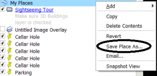
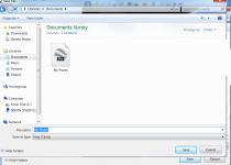
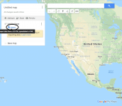
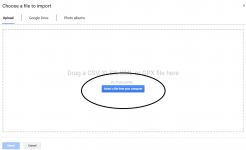
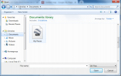
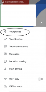
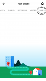
Download the "My Places" folder on Google Earth (right click it and click "Save Place As"), and saving it to my "Documents" folder on my desktop (though you can save it anywhere). Then search "My Places" on Google Search, click the first result titled, "Google Maps - My Places". remember to be logged onto your main email account when you do this. Click the red "Create A New Map" button, click the blue text that says, "Import", under the "Layer" text. Then click "Select File From Computer", and find "My Places", wherever you decided to save them. Now your places will be saved to your gmail account, and as long as you are using that account in the phone app, you should have them there. Click the "My Maps" folder on your phone, and your places should now pop up (they won't be there unless you click that). It is really much easier than it sounds, and should only take a couple minutes once you get the hang of it. Good luck, and let me know if you have anymore questions!

Step 1:
step1.png

Step 2:
step2.png

Step 3:
step3.png

Step 4:
step4.png

Step 5:
step5.png

Step 6:
step6.png

Step 7:
step7.png


Opening Them On Phone:

Step 1:
step 10.png

Step 2:
step 8.png

Step 3:
step 9.png
 

Last edited:
OP
OP
Toecutter

Toecutter

Bronze Member
Nov 30, 2018
2,433
7,443
πŸ₯‡ Banner finds
1
πŸ† Honorable Mentions:
1
Primary Interest:
All Treasure Hunting
thats it thanks coinman123!!
 

Oct 5, 2014
31,886
35,424
Massachusetts
πŸ₯‡ Banner finds
1
πŸ† Honorable Mentions:
1
Detector(s) used
Garrett: AT Pro, AT Gold & Infinium; Minelab: Explorer SE, II; Simplex; Tesoro: Tejon & Outlaw; White's: V3i
Primary Interest:
Relic Hunting
Great information, thank you for sharing! :occasion14:
 

A#1

Hero Member
Feb 18, 2018
532
657
Traverse City, Michigan
Primary Interest:
Other
My method is different than coinman123, because I found the functionality of Android based Google Maps, and Google Earth to be somewhat limited, and it didn't really do much for me.

It's really pretty easy, I do it quite often to move intel between my Windows desktop, Windows laptop, Android phone, and Android tablet on the dashboard of my treasuremobile. Once you do it a time or three it only takes seconds.

You'll need to the app Backcountry Navigator available from the Android App Store, and The use of your Google Drive for transfer.

Basically the way I do things is to overlay an image onto Google Earth. Old maps, aerials, etc.

Use Google Earth tools to mark homesites, Building locations, ruins, treelines(old), roads, railroads, etc. Placemarkers, lines, shapes, circles, etc. You can also enter notes, about all these things.

Export that data as a KML file.

Save that file to my Google Drive. Now I can move it to any device I want to.

Download the KML file to whatever device you want it on, and Import the information using the appropriate program.

This method can usually bring me within sight of a cellar hole, Keep me within boundarys of yards and clearings long since gone, follow railroads with no visible beds. I use it in some fashion every weekend.

This works in reverse too. I can mark waypoints, record tracks, make notes on the hoof with my tablet or phone, and bring them to Google earth .

Better Instruction will be lengthy and take some time, but if yall would like them, I'll edit this post to make it better.
 

Last edited:

Top Member Reactions

Users who are viewing this thread

Top