Jbabycsx
Jr. Member
So I’m looking for information on how to go about overlaying historical maps of my area with current maps. Is this something any of you have done that can explain how you do it? I’m guessing it’s as simple as printing both maps in the same scale?


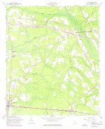
 If you go to 100% on the magnification...and look down left side of image...will see numbers...look between 3565 & 3566...and about an inch or so in will see a black square...that would be "Esla School"...or at least where it was at one time..