Walking Among Lions
Newbie
- Jun 2, 2020
- 1
- 0
- Primary Interest:
- All Treasure Hunting
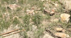
Help needed. I'm going to be metal detecting in a Riparian Boulder field along a small stream connecting to a confluence on a larger stream. The smaller stream flows all year long and is heavy with silt deposits. The larger confluence stream is very clear during low flows but also heavy in deposition when running high flow. The challenge I have is that the Riparian area is heavily dense in large rocks as well as fine clay like sediment. As a result, the rocks are stuck in a concrete mixture and during the summer months it's like digging in concrete. I have tried metal detecting with a very inexpensive detector and had no luck getting any hits. I would like to return to the area with the correct tools and conduct a proper scan of the area. My question for you hobbyist and experts alike, is what kind of metal detector should I take, if money were no object. Please keep in mind, I have to hike 700 feet elevation into a canyon and then back out. Carrying a GPR is not ideal for me but if that's what will help me detect the earth the best then I'll need to find a way. Ideally, I'm looking for recommendations on the very minimum detector I will need to detect upwards of five feet in depth. The first two feet are dry clay material. The next 3-5 feet of material comprise of small, medium and large rocks. The largest of rocks will be the size of of a 50 gallon drum, kitchen trash can, breadbox, basketball, etc. The smaller rocks, which are much more frequent and numerous are the size of footballs, softballs, baseballs, etc. and then comprised of smaller rocks and finer material, including sand/gravel mixture.
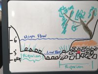
My target is a large bronze box filled with gold. Attached are pictures of the boulder field and a diagram of the riparian area.


The stream in the riparian area is about 3-5 feet deep and the bank on the north shoreline is about 3-6 feet lower than the southern deposition bank. The orange are of the river bank denotes the area that is mostly dry silt covering the boulder field which lies at least two feet below the surface of the dirt. I have marked both the high flow and low flow of the stream. Every year, this area is deposited with additional silt and rocks so the terrain changes from year to year. The mineral of the rocks is mostly granite, quartz, shale, limestone, and sandstones, etc and is located in the Rio Chama Valley.
Again, looking for guidance and recommendation how to best metal detect in this type of terrain and best tools for the job or minimum tool to do the job.
Thank you,
Walking Among Lions
My target is a large bronze box filled with gold. Attached are pictures of the boulder field and a diagram of the riparian area.


The stream in the riparian area is about 3-5 feet deep and the bank on the north shoreline is about 3-6 feet lower than the southern deposition bank. The orange are of the river bank denotes the area that is mostly dry silt covering the boulder field which lies at least two feet below the surface of the dirt. I have marked both the high flow and low flow of the stream. Every year, this area is deposited with additional silt and rocks so the terrain changes from year to year. The mineral of the rocks is mostly granite, quartz, shale, limestone, and sandstones, etc and is located in the Rio Chama Valley.
Again, looking for guidance and recommendation how to best metal detect in this type of terrain and best tools for the job or minimum tool to do the job.
Thank you,
Walking Among Lions


