Sebastian Inlet Fla....Research dead-end...need help..

ARC

Gold Member
Aug 19, 2014
37,281
131,718
Tarpon Springs
Detector(s) used
JW 8X-ML X2-VP 585
Primary Interest:
All Treasure Hunting
I'm pretty sure it is not a natural inlet. During bad storms and hurricanes the ocean would sometimes cut through for awhile but it quickly filled back in. They have to continually dredge it now so it will not fill in the channel. While used extensively by fishing boats it is of no commercial value as it is too shallow and can get very rough during storms and certain high tide events. I've white knuckled through that inlet many times.

S. inlet exist on maps back to eons.

Although its original name was AYS Inlet.
 

OP
OP
RTR

RTR

Gold Member
Nov 21, 2017
8,180
32,469
Smith Mt. Lake Va.
Detector(s) used
Teknetics Liberator
Falcon MD-20
***********
Blue Bowl
Angus MacKirk sluice
Miller Table
Primary Interest:
All Treasure Hunting
Ok... what exactly do you want to know / looking for ?

What exact answer do you seek ?

Just the "widening" date ? ? ?

We know it was first Widened in 1872....What I'm looking for is, what did it look like,say 150 years before 1872
 

OP
OP
RTR

RTR

Gold Member
Nov 21, 2017
8,180
32,469
Smith Mt. Lake Va.
Detector(s) used
Teknetics Liberator
Falcon MD-20
***********
Blue Bowl
Angus MacKirk sluice
Miller Table
Primary Interest:
All Treasure Hunting
I'm pretty sure it is not a natural inlet. During bad storms and hurricanes the ocean would sometimes cut through for awhile but it quickly filled back in. They have to continually dredge it now so it will not fill in the channel. While used extensively by fishing boats it is of no commercial value as it is too shallow and can get very rough during storms and certain high tide events. I've white knuckled through that inlet many times.

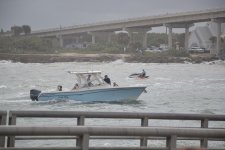
Yeah its easy to see how quick it would fill in .Tremendous volume of water flows thru that inlet.And its still-today- only 9 to 12 ft deep. This was on a somewhat calm day,imagine during a hurricane the flow . 387.JPG
 

ARC

Gold Member
Aug 19, 2014
37,281
131,718
Tarpon Springs
Detector(s) used
JW 8X-ML X2-VP 585
Primary Interest:
All Treasure Hunting
We know it was first Widened in 1872....What I'm looking for is, what did it look like,say 150 years before 1872

Well this is a "loaded" question... FOR... heh

"The sea she be a mysterious mistress".

What i mean by this is... there would only exist "depth" on charts... exact location.. width... etc... would only be speculatory.

The sea changes everything all the time... its alive... shifting... moving... carving... filling... etc etc etc.

So what is today... might not be tomorrow.

Any storm can change all of the above temporarily... or permanently... at any time... all the time.

Follow ?

So... with that babble comes the fact that unless someone surveyed it and the results exist today... it will forever be... conjecture.
 

OP
OP
RTR

RTR

Gold Member
Nov 21, 2017
8,180
32,469
Smith Mt. Lake Va.
Detector(s) used
Teknetics Liberator
Falcon MD-20
***********
Blue Bowl
Angus MacKirk sluice
Miller Table
Primary Interest:
All Treasure Hunting
Yes AARC I know of all you speak above.What I'm looking for, as you said ..."unless someone surveyed it" ...Logically Someone did in the 1700s.
 

ARC

Gold Member
Aug 19, 2014
37,281
131,718
Tarpon Springs
Detector(s) used
JW 8X-ML X2-VP 585
Primary Interest:
All Treasure Hunting
Yes AARC I know of all you speak above.What I'm looking for, as you said ..."unless someone surveyed it" ...Logically Someone did in the 1700s.

Nah man... not that i know exists... OR if there was... that would be / is available.

I have tried to "specialize" in my area primarily... which is um... daunting beings its even older and more in depth than that coast by far BUT... have spent countless hours studying that coastlines changes and documents.

I dont know though... I have some old survey maps... but as far as detailed inlet info... hmmm

I never really utilized my info of that coast as much as other areas of Florida... The main reason being... I live on this coast. :)

Um... but dont get me wrong... i do possess knowledge's of that coast very few will ever know... even privately owned data's...And have done serious research about it... and its always on the "back burner" so to speak.

My point is... i know and have seen a few things... and i have studied a map or 2 of Florida.

and nothing concerning what you ask.. comes to my mind. :)
 

Last edited:
OP
OP
RTR

RTR

Gold Member
Nov 21, 2017
8,180
32,469
Smith Mt. Lake Va.
Detector(s) used
Teknetics Liberator
Falcon MD-20
***********
Blue Bowl
Angus MacKirk sluice
Miller Table
Primary Interest:
All Treasure Hunting
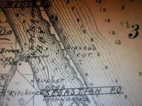
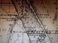
As far back as I can find .It shows up on a 1880 map as "Gibson's Cut". 004.jpg 008.jpg
 

apdp

Jr. Member
Dec 7, 2010
42
45
SW Oregon
Primary Interest:
All Treasure Hunting
I have to agree with AARC. I lived there from 96 to 2007. I had heard read/researched the inlet was man made. During major hurricanes breaches would occur at landfall but close-up in the preceding waning of the hurricane season.

A small inlet of this nature would not have existed naturally. Look at the inlets that do exist.
 

ARC

Gold Member
Aug 19, 2014
37,281
131,718
Tarpon Springs
Detector(s) used
JW 8X-ML X2-VP 585
Primary Interest:
All Treasure Hunting
I have to agree with AARC. I lived there from 96 to 2007. I had heard read/researched the inlet was man made. During major hurricanes breaches would occur at landfall but close-up in the preceding waning of the hurricane season.

A small inlet of this nature would not have existed naturally. Look at the inlets that do exist.

It was orchestrated by David Peter Gibson. Although Gibson first dug a cut at Sebastian in 1872 he did not acquire title to the property where the digging took place until May, 1885. Gibson's Cut, as his inlet was known then, appears as a feature in a U.S. National Geodetic Survey map drawn in the winter of 1880-81.

https://en.wikipedia.org/wiki/Sebastian_Inlet
 

OP
OP
RTR

RTR

Gold Member
Nov 21, 2017
8,180
32,469
Smith Mt. Lake Va.
Detector(s) used
Teknetics Liberator
Falcon MD-20
***********
Blue Bowl
Angus MacKirk sluice
Miller Table
Primary Interest:
All Treasure Hunting
It was never a natural inlet so will not be on maps before it was first dug in the 1800's.

Well that could very well be, except for one fact.All research turns up the same wording, quote > "it was made Wider in in 1872"...."it was widened in 1872". Both direct quotes. How can something be made "wider",or "widened" that didn't exists in the 1st place ?
 

newnan man

Gold Member
Aug 8, 2005
5,253
16,467
Beautiful Florida
Primary Interest:
Relic Hunting
Attempts to establish an inlet there date back to just after the Civil War. It is a known fact it has always been a man made inlet. It filled in most times it was dug until the gov't got involved and kept regular dredging going to maintain it. Most of Florida's Atlantic inlets are man made.
 

cw0909

Silver Member
Dec 24, 2006
4,364
3,222
Primary Interest:
Other
RTR, some intersting maps here some of the downloads are over 10MB, scroll down pg for more detail
the 1st map prob has a lot of info,most i cant read, did French in HS,but was not a practiced language


Beaupre's Florida, 1820, language:French
Carte géographique, statistique et historique de la Florida
Geographic, statistical and historical map of Florida
https://www.floridamemory.com/items/show/323212


East Florida Inland Navigation Sketch, 19th century
english c.1825 Fatio, Francis I.
https://www.floridamemory.com/items/show/323026


source
https://www.floridamemory.com/discover/maps/
 

newnan man

Gold Member
Aug 8, 2005
5,253
16,467
Beautiful Florida
Primary Interest:
Relic Hunting
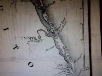
That is a pretty accurate map for the time. No inlet near Sebastian on that one. The inlet today is basically across from what is listed as the San Sebastian River which of course still exists.
 

OP
OP
RTR

RTR

Gold Member
Nov 21, 2017
8,180
32,469
Smith Mt. Lake Va.
Detector(s) used
Teknetics Liberator
Falcon MD-20
***********
Blue Bowl
Angus MacKirk sluice
Miller Table
Primary Interest:
All Treasure Hunting

ARC

Gold Member
Aug 19, 2014
37,281
131,718
Tarpon Springs
Detector(s) used
JW 8X-ML X2-VP 585
Primary Interest:
All Treasure Hunting
Thanks Much !:) I enlarged your 1837 map here.Clearly the inlet was there in your 1837 map(under a different name). Also 3 islands(right by the inlet in the Indian River) that are submerged today .Good job :)
Now ,the big question is .......Was the inlet there in the early 1700s.
>> View attachment 1945132

There have always been inlets along that bar... they have been named many different things over the centuries...

exact locations are also sometimes debatable when looking at these older maps.

There may have been a small inlet that was the base of the beginning of the desire to "widen" as stated per your research.

Never the less... inlets have always existed up and down.
 

ARC

Gold Member
Aug 19, 2014
37,281
131,718
Tarpon Springs
Detector(s) used
JW 8X-ML X2-VP 585
Primary Interest:
All Treasure Hunting
Sebastian Inlet officially opened in 1923; however, efforts to dig it out and open the flow to the lagoon date all the way back to 1872.

With the influx of settlers to the area during the mid-to-late 1800’s and into the 1900’s the quality of the stagnant water of the lagoon quickly diminished. The solution was to open up the lagoon to the ocean. At least six recorded attempts were made prior to 1923, all failing due to sand, storms and other natural causes filling in the cut.

As fortune favors the bold, the dredging of the inlet in 1923 worked with the aid of jetties and thankfully, Sebastian Inlet is what saved the community in the years to come.

In 1929 the United States plunged head-first into one of the most difficult decades, The Great Depression. With poverty gripping most families, people in the area turned to Sebastian Inlet for fishing to not only feed themselves, but also to bring in money. Commercial fishing turned out to be the saving grace for many families. Railroads in the area and the advent of ice plants rendered the ability to increase the catch and enabled shipment of fish to inland markets.

Sadly, Sebastian Inlet didn’t last long as a strong Nor’easter in the winter of 1941 closed the inlet. With the United States involvement in World War II following the attack on Pearl Harbor, the inlet remained closed for safety reasons as German U-Boats were commonly spotted off the coast of Florida.

Following the War, the US Navy Demolitions Unit who trained just south of Sebastian left a surplus of explosives behind that was used to blast the inlet open once again. Learning from past mistakes, a larger jetty was planned on each side of the inlet and constructed continued throughout the 1950’s until it’s completion.

Sebastian Inlet has remained open since then.
 

Top Member Reactions

Users who are viewing this thread

Top