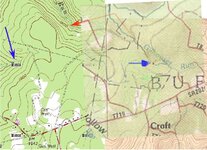
help interpreting this map ?

OP
OP
P

Pa.Billy

Full Member
May 10, 2008
161
12
Indiana Co. Pa......... finds include,confedera
Detector(s) used
Garrett 2500
an update on this homestead,I had planned on going out this evening (Sunday) but a line of T-storms are headed my way. I've included a 1871 map of this area,the blue arrow matches up a homestead to give you some perspective. I think we can now put a name of this new site am after the S. Roser homestead ! I've been wanting to look for these other several homesteads including W.M. Millen (just to the south) etc for years but didn't know where to start.Hopefully once I find the Roser estate the rest will fall in place !

1871.jpg
 

OP
OP
P

Pa.Billy

Full Member
May 10, 2008
161
12
Indiana Co. Pa......... finds include,confedera
Detector(s) used
Garrett 2500
SwampHunter said:
That map is a bit better in ways. I don't think the rouser house shows on the first old map that you posted.

Looking at the aerial photos from Terraserver it looks like there is a structure where I think the S. Roser house is located judging from the 1871 map you posted with all of the other info.
Keep in mind that none of these maps will match up exactly. Modern topos don't match up exactly to aerial photos even.

That 1871 map will be a great resource to you.

Good luck!

Hi swamphunter these 2 red X's show where the foundations are at.I don't see how you could have seen a structure from a aerial pic in that heavily wooded area. I think that was the roser homestead on that first brown colored map pointed to by the green arrow.
swamphunter.jpg
 

Top Member Reactions

Users who are viewing this thread

Top