In search of a Church,help ?

Pa.Billy

Full Member
May 10, 2008
161
12
Indiana Co. Pa......... finds include,confedera
Detector(s) used
Garrett 2500
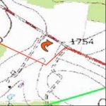
Hi everyone,I thought I would solicit you ideas again on a location of a old church this time.The left map is from 1902,I've lined up some know dwelling that am sure are accurate to give you some perspective. I'm looking for that church which is pointed to by the small pink arrow. I think it's pretty easy to get the good general location but I was hoping to get real close on this estimation because there's nothing there anymore and I've never seen a foundation from the road. I hope the road didn't swallow it up.You can alter the pic and upload again if you like and post it here in the thread.This is owned by Amish on both sides of the road,I don't know what they think about metal detectors and detecting on their land :-( ? :-)


SeekingChurch.jpg
 

Montana Jim

Gold Member
Sep 18, 2006
11,697
148
Montana
Pa.Billy said:
thanks for your input Jim,my conclusion is that the church is a little south of the present day road....to update this reply you could be right,I hope your not though :-)

Interesting... the important thing is that the area around the church would also hold treasures depending on how big the new road is... I'd search all around it on both sides anyways...

can Google Earth give you any more details?
 

OP
OP
P

Pa.Billy

Full Member
May 10, 2008
161
12
Indiana Co. Pa......... finds include,confedera
Detector(s) used
Garrett 2500
yes thanks Jim,I was thinking the same thing,the area on either side of the road might be worth checking out. This is a minor road with no lines on it so they didn't disturb a wide area when they straightened it am sure. I'm still not sure what section of the new road it's on though.
 

OP
OP
P

Pa.Billy

Full Member
May 10, 2008
161
12
Indiana Co. Pa......... finds include,confedera
Detector(s) used
Garrett 2500
an update,I went to the Amish farm (indicated by the red arrow in the first pic in this thread,a nice young man and owner of the farm.I asked him if he knew the location of the church near the road.He had a puzzled look on his face then he said I know there was a school up near the power line (blue arrows in this pic) which he said was also where the road went through his property.I thought to myself duh,why didn't I notice the electric line and piece it together. So I guess this doubled as a school/church.As I left I could clearly see the grade of the old road.But he couldn't tell me the exact location,He said that sometime back in the 30's they moved the school down to the location indicated by the small pink arrow in the bottom left of this pic,obviously that was time they straightened the road. I asked him about the foundation and he said they probably took the stones down along with the building.
He said he had no problem with me looking around and detecting around the site. Although he got a strange look in his eyes when I mentioned the metal detector :-) So I guess this move it from the road any :-(

churchaerial22.jpg
 

baspinall

Bronze Member
Jul 23, 2006
2,463
844
Pennsylvania
🥇 Banner finds
1
Detector(s) used
XP Deus
Minelab Equinox 800
GPX 4500
Primary Interest:
All Treasure Hunting
What I would do is open google earth and import the old topo map as an overlay. Line up the roads. You can also get an accurate longitude/latitude off that if you have acces to a GPS.

B
 

StogieJim

Jr. Member
Feb 26, 2007
88
5
Colorado Springs, CO
Detector(s) used
Exp 2, Tejon, & Compadre
Primary Interest:
All Treasure Hunting
Hi,

My 2cents... Registration tough. Managed to fit the general topography and locations of two houses nearest the church. Shown is new map with old road and location of church from old map. Don't take the point of the arrow literally that's just where the mapmaker put the icon. I'd suggest using the point where the new and old roads separate and search just off the corner. Seems like the old road did a turn right at the church and I'd bet the church is within 100' of the corner.

Best of luck,

Jim
 

Attachments

  • ChurchLocation.jpg
    ChurchLocation.jpg
    12.8 KB · Views: 118
OP
OP
P

Pa.Billy

Full Member
May 10, 2008
161
12
Indiana Co. Pa......... finds include,confedera
Detector(s) used
Garrett 2500
Hi Jim,thanks for all your help. You add a little bit of a twist to the location. I had the old road taking a 90 degree turn to the left,you have it on a little less of an angle. I can't help to wonder if this farm road in this pic below indicated by the red arrows didn't have something to do with the location of the church. Possibly when they straightened the road they still detoured around the church for a while ?! Something at least is going on there,seems odd to me If this farm road didn't have anything to do with the church I wonder what the odds are that the church sat on what is now the public road........

churchaerial23.jpg
 

nc-joe

Hero Member
Dec 1, 2006
710
4
Concord, NC
Detector(s) used
White's DFX and Minelab Explorer SE
appears the post right above this shows the actual road, not a "farm" road or "detour" but the actual turn just before the Church. I would start hunting the right edge of the brown field and into the treeline. Also, I would go across the street, the other side of the current road would have been the front yard. Most activity at old Churches took place on the side yard, that's why I would hit the brown filed and the treeline first.
 

Top Member Reactions

Users who are viewing this thread

Top