The Castle Rock conglomerate can be traced NW to Coal Creek Canyon and appears as far south as The Air Force Academy. It was once a continuous sheet extending up to 50 miles out from the front range and at least 100' thick in places. It has been eroded and concentrated by the many streams that run in the area. My first choice would be Plum Creek and it's tributaries.
Great information. The Colorado School of Mines has a write up on the area from 1933. I need to see if I can find a copy to read thru. Its a large area to look, but very close to where I live.
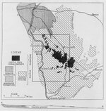
Is that the 1930's data? I think there is more current (1960-1980's) information that expands the known area of coverage. It's been so long I couldn't tell you where I found the report though, but the mental picture I have of the drawing in the report showed a larger area. I thought it spread wider toward the south, swung back toward the base of the mountains near the Academy. Anyone have the latest Geologic map of this area?
I have no date on the map. I found it when looking at a site that discussed flooding that occurred in Castle Rock and Plum Creek in 1965. The map does give you some idea about the size of the potential area to look at - there are hundreds of watersheds in that area (quite a lot on farm property - mostly used for grazing). One of the challenges of Gold prospecting is that sometimes there are often few clues that an area might be promising - the clues might have been there millions of years ago, but that doesn't often help.
"Richardson, G. B., U. S. Geol. Survey Geol. Atlas, Castle Rock folio (No. 198), 1915.
One of the early finds of gold in Colorado was made in 1B58
in Russellville Gulch, about 5 miles southeast of Franktown l
and ever since then there has been desultory prospecting for
placer gold in that vicinity. The chief localities explored,
besides Russellville Gulch, are Ronk Gulch and Gold Run, a
few miles southwest of Elizabeth, and Newlin Gulch, 7 miles
northeast of Sedalia. Recently there has been renewed activity
on Newlin Gulch, in and adjacent to sec. 36, T. 6 S., R. 67 W.,
where several drifts have been driven into the alluvial deposits
bordering the gulch. No considerable amount of gold has been
found, but the fact of its actual presence has served to maintain
sporadic interest in the occurrence.
The gold had its source in the mountains and was carried to
the quadrangle with the associated sediments by streams, becoming
finer and finer grained by transport. The gulches where
gold has been found are cut in the Dawson arkose, but the
divides are capped by the Castle Rock conglomerate. With
which of these formations the gold originally was laid down is
not known. In view of the more vigorous stream action that
accompanied the deposition of the conglomerate it seems probable
that the gold was derived from it and later accumulated
in alluvial deposits in the present valleys. Undoubtedly it has
been deposited, eroded, and redeposited a number of times.
The product is reported to be in general very fine, practically
flour gold, and this fact, taken in connection with the difficulty
of obtaining water economically and in sufficient quantity for
work on a large scale, has so far caused the deposit to have
little commercial importance. Several attempts in which large
sums of money are said to have been spent resulted in failures.
But on the other hand the gold has afforded a poor living to
some persons at times when more profitable employment was
lacking. The value of these deposits can not be determined
until the area is systematically prospected.