Anyone Used MinerDiggins Gold Atlas - Claims To Fill Gap In Old GeoCommunicator

Desert Hermit

Jr. Member
Feb 1, 2014
86
75
Randsburg, California
Detector(s) used
MineLab GPX 5000
Primary Interest:
Prospecting
I just ran across this info on a website:

A Quick Guide to Finding BLM Mining Claims with the MinerDiggins Gold Atlas

By Ruby Miner

The USGS provides an information website called the GeoCommunicator. This website used to be a "One-Stop" shop for finding information about land status, mining claims, grazing allotments and much more. This website has stopped providing much of the information useful to prospectors, such as mining claims and land status.

We have created the - MinerDiggins Gold Atlas to help fill the void left by these changes. The Gold Atlas uses Google Earth to display data that can aid prospectors in their search for Gold.

I downloaded it here: MinerDiggins Gold Atlas it's toward the last section of the page.

This thing is loaded with data and you really have to be selective in the column on the left or it'll take forever to load.

Just wondering if anyone has used this and if so would you recommend it?
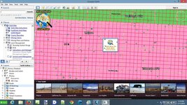
minerdiggins.jpg
 

Upvote 0

Goodyguy

Gold Member
Mar 10, 2007
6,489
6,895
Arizona
Detector(s) used
Whites TM 808, Whites GMT, Tesoro Lobo Super Traq, Fisher Gold Bug 2, Suction Dredges, Trommels, Gold Vacs, High Bankers, Fluid bed Gold Traps, Rock Crushers, Sluices, Dry Washers, Miller Tables, Rp4
Primary Interest:
All Treasure Hunting
Thanks Desert Hermit :icon_thumleft:

That's a good tool and it's FREEEEEEE !!!
It does load the data slowly but for the price you cant beat it!

GG~
 

Last edited:

Terry Soloman

Gold Member
May 28, 2010
19,421
30,102
White Plains, New York
🥇 Banner finds
1
🏆 Honorable Mentions:
1
Detector(s) used
Nokta Makro Legend// Pulsedive// Minelab GPZ 7000// Vanquish 540// Minelab Pro Find 35// Dune Kraken Sandscoop// Grave Digger Tools Tombstone shovel & Sidekick digger// Bunk's Hermit Pick
Primary Interest:
Metal Detecting
I have been using their Footprints since 2010, and they are the BEST tool out there! Here is a review I wrote several years ago:

“FootPrints” Gold Prospecting & Map Making Software
By Terry Soloman [email protected]
*
[FONT=Times
New Roman]I was able to review three separate Footprints DVDs: The Little San Domingo FootPrint; Vulture West FootPrint; and the Black Canyon City FootPrint. I asked two professional Arizona gold prospectors – who have staked and currently own Arizona gold claims, to assist me in this review. I also invited a gold prospecting “Greenhorn” to give me his thoughts.[/FONT]

*
What is “Footprints?”
*


This is a detailed DVD that puts almost two-dozen important and meaningful tools into the hands of the individual prospector. For instance, the “Little San Domingo FootPrint,” is a 35-square-mile, high resolution “Orthos” map of one of the richest placer gold areas in Arizona. Ortho photography, or “Orthos”, is a type of high resolution aerial photography which has been digitally manipulated so that its dimensions represent true dimensions on the earth’s surface. All of these FootPrints DVDs, feature an incredible 9” resolution. When you consider the extreme cost of Orthos mapping, from $18,000 - $20,000 per 10-square mile block, this software would be a bargain if it just stopped there. But these software programs are much more than just a great map.
*


The Little San Domingo FootPrint, covers an area just 35-miles northwest of Phoenix, Arizona. This DVD shows the location and outline of all known gold claims in the district and, you can pull up actual copies of the claim documents and maps filed with the County and BLM. The claims are mapped to their actual boundaries, based on original county filings. You will not find this map layer anywhere else. It provides layers of mapping including land ownership; Private; Federal; State; Forest Service, township, range and section. [FONT=Times
New Roman]To the new and seasoned gold prospector alike, this is a powerful tool. It allows you, at a glance, to see areas that have already been claimed – and more importantly, land that has not been claimed. The software then allows you to move in for a very close look at that open land, and gives you more than a dozen more tools to help evaluate your possible new claim - without ever leaving your computer chair.[/FONT]

*
[FONT=Times
New Roman][/FONT]


The two professional gold prospectors both commented on the dexterity of this software, and its ability to perform a number of difficult and complex jobs. One tool they were both drawn to immediately was the “Hydrology Tool.” Each FootPrint provides a data set showing streams, rivers, washes and drainage basins. Water flow and wetness map layers are also included to help visualize water movement. This tool allows you to chart natural water flow and movement through the areas you are interested in, giving you hard clues to where placer gold may be located – and cutting down your testing time by showing you where to look before ever stepping foot on the claim. I watched as the two prospectors combined tools and map layers, then compared notes and tried even more combinations.
*
[FONT=Times
New Roman][/FONT]


They used several tools, including the FootPrints “Geology” layer which indicates basic rock types and age. They also liked the shaded elevation maps, and USGS topo maps, which along with high resolution imagery, helped them to understand the terrain and how to get into it. As I watched these skilled gold miners work their new found tool, I wondered how my Greenhorn would fare. One of the things I like the most about this software is its stability. It will run on just about any computer, old or new. One of the things I did not like, was the load time (2.5Gb), almost 14-minutes on my 2007 XP Dell Inspiron Notebook. A problem I quickly forgot about after opening the program.
*
[FONT=Times
New Roman][/FONT]


To test the GPS mapping tools included in FootPrints, we drove out to a spot in the Little San Domingo, chosen by my two professionals using the FootPrints DVD. We took GPS waypoints in several locations, simulating gold claim boundaries, test areas and gold nugget finds. We were able to take those readings and successfully add them to our custom FootPrints map, then print out a full color, high resolution map copy. We were all very impressed with the results. After explaining the basics of the software and how to use it, I turned the Greenhorn (a 50-something business owner from the East Coast who was in town for a gold prospecting vacation) loose with it. I was surprised at how quickly he seemed to understand what he was looking at. He really got excited after finding an area that looked promising to him, and seeing it was not yet claimed.
*


I cannot really explain the functionality of the FootPrint DVDs fully in this short review. These DVDs can be used in many different ways, with multi-tiered combinations of information and images. We all agreed that this software is far superior to any other single research or mapping resource available to the individual gold prospector in Arizona – period. I look forward to future FootPrints of Rich Hill, and Greaterville. Check out: What is a FootPrint ?
 

OP
OP
D

Desert Hermit

Jr. Member
Feb 1, 2014
86
75
Randsburg, California
Detector(s) used
MineLab GPX 5000
Primary Interest:
Prospecting
Goodyguy, if it's correct the entire area I've been working has been withdrawn from mineral entry and given to the wind and solar guys. 1000's of acres gone, oh well I didn't locate anything there anyway.
 

OP
OP
D

Desert Hermit

Jr. Member
Feb 1, 2014
86
75
Randsburg, California
Detector(s) used
MineLab GPX 5000
Primary Interest:
Prospecting
Great review Terry, I'm liking what I'm seeing here. Not only that, you mention Little San Domingo in Arizona; a close friend of mine just inherited a 40 acre piece near a stream by the same name I believe it was. She told me I could live on the land for nothing and mine it also. Now I'm getting interested, maybe I should look deeper into this area.
 

Clay Diggins

Silver Member
Nov 14, 2010
4,885
14,257
The Great Southwest
Primary Interest:
Prospecting
I made that program several years ago Hermit. It has some use still but the government has taken away a lot of the data. I'm working on a new online version that will have more useful information and a better interface. Of course the new version will be free also.

Please don't confuse our free Gold Atlas with our MinerDiggins FootPrint maps. Our FootPrints are self contained and need no internet. As well as being much faster than any online program they are the only interactive maps that have the actual mining claims plotted right on the map.

Basically:

Gold Atlas - A good program to take a general look around. Internet only and free.

FootPrints - Serious maps for serious prospectors. Self contained and not free.
 

OP
OP
D

Desert Hermit

Jr. Member
Feb 1, 2014
86
75
Randsburg, California
Detector(s) used
MineLab GPX 5000
Primary Interest:
Prospecting
Clay, yes, I seen the FootPrint is not free. I'm loving the minerdiggins program and will watch for the update, wonderful work!
 

AzViper

Bronze Member
Sep 30, 2012
2,038
2,250
Arizona - Is there any other state worth visiting
Detector(s) used
Fisher Gold Bug Pro, Nokta FORS Gold, Garrett ATX, Sun Ray Gold Pro Headphones, Royal Pick, Etc.
Primary Interest:
Prospecting
I picked up Footprints for the Greaterville area while at the GPAA Expo in Mesa from Rob Allison for the expo special. Very nice to have at home and on a laptop in the truck.
 

OP
OP
D

Desert Hermit

Jr. Member
Feb 1, 2014
86
75
Randsburg, California
Detector(s) used
MineLab GPX 5000
Primary Interest:
Prospecting
AzViper, I just stumbled onto this and can see that these Footprints really should be in the arsenal of any serious prospector. I'll definitely be promoting them and the free program Clay has, on my new website.
 

goldenIrishman

Silver Member
Feb 28, 2013
3,465
6,152
Golden Valley Arid-Zona
Detector(s) used
Fisher / Gold Bug AND the MK-VII eyeballs
Primary Interest:
Other
DH,

I can attest to how well the FootPrints for Greaterville works. Using it, Robi and I were able to locate and evaluate several possible claims without having to drive over a hundred miles one way then spend days or even weeks searching for claim markers and then trying to determine just where the unclaimed areas were. This program shows both placer and lode claims and on each and everyone we checked out the corners were dead on.

Using the geology, water and elevation layers, we were able to locate a claim that has already started producing nice chunky pieces of gold. It also is accessible by road which was something that I wanted for Robi. While I'm an old Infantryman and used to hiking in remote areas, she's not. Being able to drive right up to the claim makes it easier on her and we get to work the claim together. If it was a days hike to get into the claim, I'd be spending a lot of time alone out there. ;)

For the cost of the program you just can't beat it!!! It even runs on my old dinosaur of a computer. At 800Mhz processor speed and only 256 meg of ram it's a little slow at times but it does run. I can't wait to see how it runs when I get around to building me up a new computer. Given that it also runs "stand alone" having it on a laptop gives you full access to all the information out in the field if needed. Considering that I'm lucky if I can get a cell signal in that area, not requiring an internet connection is a major plus.

As we expand our mining activities, I plan on getting the rest of the programs for Arizona so we can research new areas without having to leave home.
 

Back-of-the-boat

Gold Member
Apr 18, 2013
6,885
8,504
California
Detector(s) used
AT GOLD/Garrett /C.Scope cs4PI/Garrett(carrot) pro pointer/ 5x8 double d coil and sniper coil/Lesche digger/Lesche "T" handle shovel.
Primary Interest:
All Treasure Hunting
I made that program several years ago Hermit. It has some use still but the government has taken away a lot of the data. I'm working on a new online version that will have more useful information and a better interface. Of course the new version will be free also.

Please don't confuse our free Gold Atlas with our MinerDiggins FootPrint maps. Our FootPrints are self contained and need no internet. As well as being much faster than any online program they are the only interactive maps that have the actual mining claims plotted right on the map.

Basically:

Gold Atlas - A good program to take a general look around. Internet only and free.

FootPrints - Serious maps for serious prospectors. Self contained and not free.
Is this Arizona only or will you be doing California also?
 

PaulieNoNuggets

Jr. Member
Dec 21, 2013
43
68
Sacramento, CA
Detector(s) used
Garrett AT Gold
Primary Interest:
Prospecting
DH,

I can attest to how well the FootPrints for Greaterville works. Using it, Robi and I were able to locate and evaluate several possible claims without having to drive over a hundred miles one way then spend days or even weeks searching for claim markers and then trying to determine just where the unclaimed areas were. This program shows both placer and lode claims and on each and everyone we checked out the corners were dead on.

Using the geology, water and elevation layers, we were able to locate a claim that has already started producing nice chunky pieces of gold. It also is accessible by road which was something that I wanted for Robi. While I'm an old Infantryman and used to hiking in remote areas, she's not. Being able to drive right up to the claim makes it easier on her and we get to work the claim together. If it was a days hike to get into the claim, I'd be spending a lot of time alone out there. ;)

For the cost of the program you just can't beat it!!! It even runs on my old dinosaur of a computer. At 800Mhz processor speed and only 256 meg of ram it's a little slow at times but it does run. I can't wait to see how it runs when I get around to building me up a new computer. Given that it also runs "stand alone" having it on a laptop gives you full access to all the information out in the field if needed. Considering that I'm lucky if I can get a cell signal in that area, not requiring an internet connection is a major plus.

As we expand our mining activities, I plan on getting the rest of the programs for Arizona so we can research new areas without having to leave home.

SOLD!!! Certainly sounds like it may help in my quest, so I just ordered a copy for NF American. Hopefully I can find a bit o' dirt to call my own :)
 

Clay Diggins

Silver Member
Nov 14, 2010
4,885
14,257
The Great Southwest
Primary Interest:
Prospecting
Is this Arizona only or will you be doing California also?

Just finishing up the 9th map in Arizona. We've made two in California - The North and the Middle Forks of the American River. Lots more coming but it takes us 4 - 7 months to make one of these maps. Lots of research goes into each one.
 

rodoconnor

Bronze Member
Mar 4, 2012
1,419
1,638
Primary Interest:
All Treasure Hunting
D/H about 20 or so years ago a friend of mine [ who shall remain nameless] went to the BLM and wanted to lease all the wind rights for basically the Mojave Desert area. They had never heard of such a thing! Somebody wanted to pay for the clear blue sky. They said certainly, make us an offer. He owns the wind for next to nothing and subleases it to Zond, Wind River,etc. When they first put those things in up there in Tehachapi, they weren't even connected to the grid. They just sat there generating potential for years. It took an Initiative from the people to require them to be connected. A huge tax wright-off scam.
 

OP
OP
D

Desert Hermit

Jr. Member
Feb 1, 2014
86
75
Randsburg, California
Detector(s) used
MineLab GPX 5000
Primary Interest:
Prospecting
I made that program several years ago Hermit. It has some use still but the government has taken away a lot of the data. I'm working on a new online version that will have more useful information and a better interface. Of course the new version will be free also.

Please don't confuse our free Gold Atlas with our MinerDiggins FootPrint maps. Our FootPrints are self contained and need no internet. As well as being much faster than any online program they are the only interactive maps that have the actual mining claims plotted right on the map.

Basically:

Gold Atlas - A good program to take a general look around. Internet only and free.

FootPrints - Serious maps for serious prospectors. Self contained and not free.

Clay, I just took a look at the prices of your Footprints, for the work that goes into making them and the great service they provide, I honestly expected a price tag of two hundred or better, was I ever shocked to learn most of them are well under a hundred bucks! How do the young-ens say it today? You are da bomb!
 

OP
OP
D

Desert Hermit

Jr. Member
Feb 1, 2014
86
75
Randsburg, California
Detector(s) used
MineLab GPX 5000
Primary Interest:
Prospecting
D/H about 20 or so years ago a friend of mine [ who shall remain nameless] went to the BLM and wanted to lease all the wind rights for basically the Mojave Desert area. They had never heard of such a thing! Somebody wanted to pay for the clear blue sky. They said certainly, make us an offer. He owns the wind for next to nothing and subleases it to Zond, Wind River,etc. When they first put those things in up there in Tehachapi, they weren't even connected to the grid. They just sat there generating potential for years. It took an Initiative from the people to require them to be connected. A huge tax wright-off scam.

Hey Rod, you think we can get them to lease us any sunlight that rolls across BLM? We're probably too late, the same guy that leased the wind probably grabbed the sunlight too!
 

goldenIrishman

Silver Member
Feb 28, 2013
3,465
6,152
Golden Valley Arid-Zona
Detector(s) used
Fisher / Gold Bug AND the MK-VII eyeballs
Primary Interest:
Other
That's the truth! Clay is always ready to help others to get on the gold. From what I've seen, there's not too many areas that he doesn't know when it comes to the western states. His advice has kept me form making more than one mistake to say the least. In my book he's one of if not the most helpful person we have here in TN when it comes to prospecting!
 

rodoconnor

Bronze Member
Mar 4, 2012
1,419
1,638
Primary Interest:
All Treasure Hunting
D/H Don't laugh. The blm leases solar rights! And I wouldn't be the least bit surprized if he didn't. What an age we live in
 

Top Member Reactions

Users who are viewing this thread

Top