AU_Solitude
Sr. Member
- Feb 24, 2014
- 280
- 380
- Detector(s) used
- SDC2300, GBII, Geo Picks & Hammers
- Primary Interest:
- Prospecting
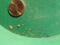
So, took a break from the daily grind and ran up to the hills today. Hit up the Euchre bar trail. Needless to say, the river was gorged - forgot about snow melt. Moved some big boulders worked the gravels underneath for four hours and didn't even pull anything but a few colors.
I panned four five gallon buckets worth of material - couldn't use the MacKirk because of the river flow.
Anyone have advice of where, what I need to do different so I don't get skunked again next time? Anyone have luck in this area?
I panned four five gallon buckets worth of material - couldn't use the MacKirk because of the river flow.
Anyone have advice of where, what I need to do different so I don't get skunked again next time? Anyone have luck in this area?


Last edited:
Upvote
0


")