USFS and BLM agency visits

Bejay

Bronze Member
Mar 10, 2014
1,026
2,530
Central Oregon Coast
Detector(s) used
Whites GMT
Garret fully underwater
Primary Interest:
Prospecting
On a different thread the question was asked: How many miners have had visits by an agency person(s) who wanted to bring forth some agency authority.......Say a visit by a USFS or BLM agent.

I have, and it was pre-emoted by a USFS District Rangers letter....and that Dist Ranger came with 4 of his staff and the Hired hand Sheriff who was funded/employed by the USFS.

Also:

Last year I met and talked to a Douglas County Oregon Sheriff (a nice guy) who was employed by the BLM. He was putting up emergency road closure signs for the BLM.... (Douglas Complex forest fire). He even explained to me he was acting on behalf of as an employee of the BLM. He told me personally he does not harass miners.

The reason for this post/thread will be to see how many miners have actually had "out in the field" visits/confrontations/etc. with agency personnel.....And we may be able to clarify some of the issues miners are being asked to deal with.

A prospector/miner has a lot of potential issues to deal with.


Bejay
 

Upvote 0

goldenIrishman

Silver Member
Feb 28, 2013
3,465
6,152
Golden Valley Arid-Zona
Detector(s) used
Fisher / Gold Bug AND the MK-VII eyeballs
Primary Interest:
Other
We haven't had any visits at the claim yet but I figure it's only a matter of time before they come around. I will be following this thread closely. I figure it's much better to learn from what has happened to others and to emulate what they did right and avoid what they did wrong.
 

jog

Bronze Member
Nov 28, 2008
1,364
682
Tillamook Oregon
Detector(s) used
Whites MXT / GMT
Primary Interest:
All Treasure Hunting
Bejay
BLM has been asking me if I am mining under casual use, also asking questions about my water source. I just tell them I am mining....plain & simple. I suspect that there casual use does not fall under a Title USC code?
 

OP
OP
B

Bejay

Bronze Member
Mar 10, 2014
1,026
2,530
Central Oregon Coast
Detector(s) used
Whites GMT
Garret fully underwater
Primary Interest:
Prospecting
Bejay
BLM has been asking me if I am mining under casual use, also asking questions about my water source. I just tell them I am mining....plain & simple. I suspect that there casual use does not fall under a Title USC code?

Next time they mention "casual use" ask them to reference the CFR that brings forth that issue.

But you may find this of interest:

"Where both the Forest Service and the BLM are required to adhere the congressional public land management mandate of the Federal Land Management Policy Act, FLPMA, which expressly states at 43 USC 1732 (b), that, “. . . no provision of this section or any other section of this Act shall in any way amend the Mining Law of 1872 or
impair the rights of any locators or claims under that Act, including, but not limited to, rights of ingress and egress” any assertion of federal authority by agency, such as the BLM or the Forest Service, impairing, obstructing or closing access against, or managing the surface of Locatable mineral deposit property on public domain in-holding the public land, or otherwise interfering in any way is committed contrary to the laws of the United States of America, a breach of fiduciary duty, and an intentional and negligent trust tort."

Then read this: http://law.justia.com/cfr/title43/43-2.1.1.3.69.html#43:2.1.1.3.69.5.140.6
Take note of these terms in the doc: Do you see the word "casual" anywhere?

{Quote}
How are certain terms in this subpart defined?
top
As used in this subpart the term:

Mining laws means all laws that apply to mining of locatable minerals on public lands and which make public lands available for development of locatable minerals. This includes, but is not limited to, the general authorities relating to mining of locatable minerals or to the public lands on which this subpart is based and case law which interprets those authorities.

Mining operations means all functions, work, facilities, and activities reasonably incident to mining or processing of mineral deposits. It includes building roads and other means of access to a mining claim or millsite on public lands.

Occupancy means full or part-time residence on the public lands. It also means activities that involve residence; the construction, presence, or maintenance of temporary or permanent structures that may be used for such purposes; or the use of a watchman or caretaker for the purpose of monitoring activities. Residence or structures include, but are not limited to, barriers to access, fences, tents, motor homes, trailers, cabins, houses, buildings, and storage of equipment or supplies.

Permanent structure means a structure fixed to the ground by any of the various types of foundations, slabs, piers, poles, or other means allowed by building codes. The term also includes a structure placed on the ground that lacks foundations, slabs, piers, or poles, and that can only be moved through disassembly into its component parts or by techniques commonly used in house moving. The term does not apply to tents or lean-tos.

Public lands
means lands open to the operation of the mining laws which BLM administers, including lands covered by unpatented mining claims or millsites. [FUNNY THING THEY DON'T MENTION PUBLIC DOMAIN]
Prospecting or exploration means the search for mineral deposits by geological, geophysical, geochemical, or other techniques. It also includes, but is not limited to, sampling, drilling, or developing surface or underground workings to evaluate the type, extent, quantity, or quality of mineral values present.

Reasonably incident means the statutory standard “prospecting, mining, or processing operations and uses reasonably incident thereto” (30 U.S.C. 612). It is a shortened version of the statutory standard. It includes those actions or expenditures of labor and resources by a person of ordinary prudence to prospect, explore, define, develop, mine, or beneficiate a valuable mineral deposit, using methods, structures, and equipment appropriate to the geological terrain, mineral deposit, and stage of development and reasonably related activities. [FUNNY THING THEY DON'T SAY LOCATABLE MINERALS]
Substantially regular work means work on, or that substantially and directly benefits, a mineral property, including nearby properties under your control. The work must be associated with the search for and development of mineral deposits or the processing of ores. It includes active and continuing exploration, mining, and beneficiation or processing of ores. It may also include assembly or maintenance of equipment, work on physical improvements, and procurement of supplies, incidental to activities meeting the conditions of §§3715.2 and 3715.2–1. It may also include off-site trips associated with these activities. The term also includes a seasonal, but recurring, work program.

Unnecessary or undue degradation, as applied to unauthorized uses, means those activities that are not reasonably incident and are not authorized under any other applicable law or regulation. As applied to authorized uses, the term is used as defined in 43 CFR 3802.0–5 and 3809.0–5.

[61 FR 37125, July 16, 1996, as amended at 62 FR 59822, Nov. 5, 1997]" {End Quote}


Read More here: http://www.law.cornell.edu/uscode/text/43 and http://www.law.cornell.edu/uscode/text/30/chapter-2


Bejay
 

Last edited:

jog

Bronze Member
Nov 28, 2008
1,364
682
Tillamook Oregon
Detector(s) used
Whites MXT / GMT
Primary Interest:
All Treasure Hunting
Thanks Bejay
This all started with a road because they are ReMapping the area & were trying to tell me that my rd was a trail & I would have to file a NOI to use it. I flat out told them that I would not go there with them. I have done My research on the road and I found the guy that built the rd back in 1978 & had a good long talk with him. He is going to right a letter to me stating that the rd was built for access to his mine with all records showing that the rd was built as a Mine to Market Rd.
Now there trying to tell me that the rocks that are stacked from the 80s may be Historical :icon_scratch: yea right. I am sure I will get a visit from them when I am over there later.
Thanks for the good info above, have I added it to my folder.
 

AzViper

Bronze Member
Sep 30, 2012
2,038
2,250
Arizona - Is there any other state worth visiting
Detector(s) used
Fisher Gold Bug Pro, Nokta FORS Gold, Garrett ATX, Sun Ray Gold Pro Headphones, Royal Pick, Etc.
Primary Interest:
Prospecting
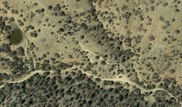
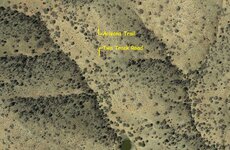
Here is a scenario where access is being denied by the FS. The white circle is the trail head for the Arizona Trail that runs north and south for nearly 900 miles across the state of Arizona, yet many hikers have to use other two track roads to gain access to the trailhead. The trail begins right in the middle of a Placer Claim. Just above this Placer Claim is a Lode Claim that has been in existence from the 50’s from what I am told. The guy who owns the Load Claim has now found 4 drifts into the mountain some being a few hundred feet long. The gentleman who owns the Load Claim has to hike into his Load Claim with his tools a quarter mile up the ravine in the middle of the photo to access his claim. I believe and have yet looked into it that this two track road use to be the miner’s road into the Lode Claim yet this trail head only became a trail head in 2009. If the claim owners can prove that the two track road was in place prior to 1976 I believe they have a case to get this two track road reopened to vehicle traffic. There is no reason that the hiker and the miner cannot use this same two track road. It's very obvious its a two track road. Hikers walking side by side 6 feet apart did not make this road.

Claim.jpg
 

Last edited:

Oakview2

Silver Member
Feb 4, 2012
2,807
3,348
Prather CA
Detector(s) used
Whites GMT
Primary Interest:
Other
Cut the chain with boltcutters, put their lock on it, and be done with these sorry paper shovelers.
 

Clay Diggins

Silver Member
Nov 14, 2010
4,885
14,258
The Great Southwest
Primary Interest:
Prospecting
If the claim owners can prove that the two track road was in place prior to 1974 I believe thay have a case to get this two track road reopened to vehicle traffic.

The critical year for the public right of way is 1976 - the year the FLPMA was passed. The place to look for evidence of public use would be a topo from before 1976. There is no need to prove a claim of right. If it was in public use before 1976 it can't be closed to current public use, it is grandfathered in by law.
 

AzViper

Bronze Member
Sep 30, 2012
2,038
2,250
Arizona - Is there any other state worth visiting
Detector(s) used
Fisher Gold Bug Pro, Nokta FORS Gold, Garrett ATX, Sun Ray Gold Pro Headphones, Royal Pick, Etc.
Primary Interest:
Prospecting
The critical year for the public right of way is 1976 - the year the FLPMA was passed. The place to look for evidence of public use would be a topo from before 1976. There is no need to prove a claim of right. If it was in public use before 1976 it can't be closed to current public use, it is grandfathered in by law.

Barry I knew you would come to the rescue. I could not remember the year as I lost the email from you. USGS has topo's of that area dating 1972 just can't access them. Going to try Tucson, Maps tomorrow.

177652 GRANITE MTS NE
177654 GRANITE MTS NW
177414 GRANITE MTS SE
177416 GRANITE MTS SW
 

Last edited:

Clay Diggins

Silver Member
Nov 14, 2010
4,885
14,258
The Great Southwest
Primary Interest:
Prospecting
Barry I knew you would come to the rescue. I could not remember the year as I lost the email from you. USGS has topo's of that area dating 1972 just can't access them. Going to try Tucson, Maps tomorrow.

177652 GRANITE MTS NE
177654 GRANITE MTS NW
177414 GRANITE MTS SE
177416 GRANITE MTS SW

You don't need to leave your easy chair Keith. Virtually every topo map ever made is available online now. Many areas have as many as several versions per year with handwritten notes.

It will take some digging since there are so many and as I'm sure you know many "inconvienient" land features have been removed through the years. Check out all the maps for the area before 1976 and if it's marked on any of them they can't say it wasn't ever a known public way. :thumbsup:

I would have looked that up for you a few weeks ago when this first came up but I've been busier than a cat on a hot tin roof this month.

HERE'S THE LINK TO ALL THE OFFICIAL USGS HISTORICAL TOPO MAPS

That's a great study link for anyone looking at a specific area for prospecting too. We use this a lot when when we are looking for the best resources for our maps.

Heavy Pans
 

goldenIrishman

Silver Member
Feb 28, 2013
3,465
6,152
Golden Valley Arid-Zona
Detector(s) used
Fisher / Gold Bug AND the MK-VII eyeballs
Primary Interest:
Other
LOL I was trying to post and my POS computer crashed on me!!!!

I know that road well as it run right through my claim and up to the lode claim above me. Being able to use it would be fantastic! The topo map I have for that area shows it but is dated 1981 so it's not quite old enough for this.

Getting that road oped back up would be a life saver for the guy above me. He had to haul in a 300+ pound gate for one of his audits a while back and it took a team of 4 guys most of the day to get it across my claim and up to his. If that road had been open, he could have hauled it right to where it needed to go with his truck!

The "Road closed" sign they put up is about worthless anyway. I've seen several people come driving down the hill after going in by the pond which has no closure markings on it at all.
 

AzViper

Bronze Member
Sep 30, 2012
2,038
2,250
Arizona - Is there any other state worth visiting
Detector(s) used
Fisher Gold Bug Pro, Nokta FORS Gold, Garrett ATX, Sun Ray Gold Pro Headphones, Royal Pick, Etc.
Primary Interest:
Prospecting
LOL I was trying to post and my POS computer crashed on me!!!!

I know that road well as it run right through my claim and up to the lode claim above me. Being able to use it would be fantastic! The topo map I have for that area shows it but is dated 1981 so it's not quite old enough for this.

Getting that road oped back up would be a life saver for the guy above me. He had to haul in a 300+ pound gate for one of his audits a while back and it took a team of 4 guys most of the day to get it across my claim and up to his. If that road had been open, he could have hauled it right to where it needed to go with his truck!

The "Road closed" sign they put up is about worthless anyway. I've seen several people come driving down the hill after going in by the pond which has no closure markings on it at all.

Jeff I was speaking on your behalf, just did not want to make it public unless you stated otherwise.
 

AzViper

Bronze Member
Sep 30, 2012
2,038
2,250
Arizona - Is there any other state worth visiting
Detector(s) used
Fisher Gold Bug Pro, Nokta FORS Gold, Garrett ATX, Sun Ray Gold Pro Headphones, Royal Pick, Etc.
Primary Interest:
Prospecting
You don't need to leave your easy chair Keith. Virtually every topo map ever made is available online now. Many areas have as many as several versions per year with handwritten notes.

It will take some digging since there are so many and as I'm sure you know many "inconvienient" land features have been removed through the years. Check out all the maps for the area before 1976 and if it's marked on any of them they can't say it wasn't ever a known public way. :thumbsup:

I would have looked that up for you a few weeks ago when this first came up but I've been busier than a cat on a hot tin roof this month.

HERE'S THE LINK TO ALL THE OFFICIAL USGS HISTORICAL TOPO MAPS

That's a great study link for anyone looking at a specific area for prospecting too. We use this a lot when when we are looking for the best resources for our maps.

Heavy Pans

Barry I had already tried that site of which the curent map is dated 2011 for the area I am searching for.
 

Clay Diggins

Silver Member
Nov 14, 2010
4,885
14,258
The Great Southwest
Primary Interest:
Prospecting
Barry I had already tried that site of which the curent map is dated 2011 for the area I am searching for.

Keith the map you are looking for is the HELVETIA 7.5 minute quad edited in 1976.

Your FootPrint shows that topo map in the forest service version from 1975. (Right Click on the layer name and you will see the source data for any layer)

Both those maps show the two track as a recognized public way.

Looks like that public road is open to all. :thumbsup:
 

AzViper

Bronze Member
Sep 30, 2012
2,038
2,250
Arizona - Is there any other state worth visiting
Detector(s) used
Fisher Gold Bug Pro, Nokta FORS Gold, Garrett ATX, Sun Ray Gold Pro Headphones, Royal Pick, Etc.
Primary Interest:
Prospecting
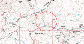
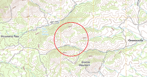
Thank you Barry. Look at this, the 1975 and the 2012 USGS Topo maps. The jeep trail is not included in the 2012 map but is present in the 1975 map... GoldenIrishman looks like you and the lode claim owner has access to your claims.

Helvetia Topo Map.png Claims.jpg Helvetia Topo 2012 Map.png
 

Last edited:

63bkpkr

Silver Member
Aug 9, 2007
4,069
4,618
Southern California
Detector(s) used
XLT, GMT, 6000D Coinmaster
Primary Interest:
All Treasure Hunting
AzV, thank you for that. It is ugly when the Government Thinks it means more than the citizens do. Jerks! 63bkpkr
 

OP
OP
B

Bejay

Bronze Member
Mar 10, 2014
1,026
2,530
Central Oregon Coast
Detector(s) used
Whites GMT
Garret fully underwater
Primary Interest:
Prospecting
Keith the map you are looking for is the HELVETIA 7.5 minute quad edited in 1976.

Your FootPrint shows that topo map in the forest service version from 1975. (Right Click on the layer name and you will see the source data for any layer)

Both those maps show the two track as a recognized public way.

Looks like that public road is open to all. :thumbsup:

Here is some info that may help that happen: RS 2477 Roads & Rights-of-Way (Summary) - ICMJ's Prospecting and Mining Journal

Bejay
 

delnorter

Hero Member
Oct 28, 2008
907
2,300
Northern California
Primary Interest:
All Treasure Hunting
As Clay said, a lot of information is being removed from the older maps when updated to new ones. Just look at all the eliminated items showing on just a small portion of these two maps. Save these old ones to your library of files and store remote to your computer.

Mike
 

Hoser John

Gold Member
Mar 22, 2003
5,854
6,721
Redding,Calif.
Primary Interest:
All Treasure Hunting
The 1872 mining laws of egress and regress were further annotated,codified and amended under the Nixon administration to further miners protection in these matters. When they play games,you play games as bolt cutters and your lock in the chain line cures all. Always carry a spare. Over the past 60+ years I've had many 100s a visits,confrontations,hastles and always worked things out with my legal file as when confronted with the TRUTH to confront their insipid lies they shut up and go away. Never a single ticket EVER for nuttn'. Once they find out they can't bs,lie and run ya off they don't usually come back. For every set of circumstances require different plans of actions also. Just go up a level in management with the agency in question,then his boss and on up the ladder seems to work just fine. John
 

Top Member Reactions

Users who are viewing this thread

Top