CLAIM JUMPING and how to avoid it

Gold_Striker

Full Member
Sep 27, 2010
105
5
Denver,CO
Detector(s) used
xterra 705 by minelab
Primary Interest:
Prospecting
New to prospecting IRL, so how do I notice the boundries of a claim if I find myself accidently entering one by a main road of course or obviously well used trail. I know to look around for.

Piles of rocks
signs
markers
some kind of visial indicator

It's not enough to rely on the BLM maps if you ask me. Maybe someone marked it and is headed to the office.
 

Upvote 0

russau

Gold Member
May 29, 2005
7,280
6,736
St. Louis, missouri
Do your own research into the laws and head to the County Recorder of Deeds to see whos paying taxs on that area your looking at. the BLM and the frigging FS aint much help and they seem to be bent on giving you "their own version" of the law.
 

2cmorau

Bronze Member
Nov 8, 2010
1,608
1,294
Camptonville, CA
Detector(s) used
GMT&GM3 Whites MXT Pro, Shadow X5, Fisher 1280, OMG and the TDI
Primary Interest:
Prospecting
not sure about Denver best bet is to go to BLM office, and check out the township, range and section number your interested in, and pull jackets sometimes the claim holder will put a map of the claim and draw out his/her interest, county seat will only have basic info. any clubs in your area?
 

fowledup

Silver Member
Jul 21, 2013
2,757
5,162
Northern California
Detector(s) used
Whites GMT V/SAT
Primary Interest:
Prospecting
When in doubt back out! Not sure about Co. but some states like Kalifornastan do not require boundary or corner markers, so unless you look at a map from the county or possibly BLM (doubtful tho) you wouldn't know. However if there is a copy of the claim at the marker and you know where the nearest USGS markers are you should be able to figure it out from that. Always carry good maps, a compass, or gps for the areas your headed. If you know you'll have cell service there are some pretty good tool apps available. Best thing is to do your research before the trip, you might luck out and find an open piece to call your own. Good luck!
 

OP
OP
G

Gold_Striker

Full Member
Sep 27, 2010
105
5
Denver,CO
Detector(s) used
xterra 705 by minelab
Primary Interest:
Prospecting
west fairplay

When in doubt back out! Not sure about Co. but some states like Kalifornastan do not require boundary or corner markers, so unless you look at a map from the county or possibly BLM (doubtful tho) you wouldn't know. However if there is a copy of the claim at the marker and you know where the nearest USGS markers are you should be able to figure it out from that. Always carry good maps, a compass, or gps for the areas your headed. If you know you'll have cell service there are some pretty good tool apps available. Best thing is to do your research before the trip, you might luck out and find an open piece to call your own. Good luck!

West Fairplay at the divide or near it is where I want to check things out so its all Pike National Forest I think. You can hardly turn around without falling into a mine. Takes about 1hr 30 min to get there from Denver,CO.
 

rodoconnor

Bronze Member
Mar 4, 2012
1,419
1,638
Primary Interest:
All Treasure Hunting
While researching a place of interest you, will notice a lot of claims that have returned to public domain. More than you would have thought. People get tired t of the gov. BS, the expense ,etc and walk away. Paper claimers mke some good $$ doing this.
 

fowledup

Silver Member
Jul 21, 2013
2,757
5,162
Northern California
Detector(s) used
Whites GMT V/SAT
Primary Interest:
Prospecting
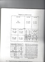
One other thing that will help is you need to understand how Placer claims are laid out on a map. If I'm in error or not making sense someone feel free to jump in and correct me. Here goes, as a general rule placer claims are made up in units of 20 acres. You can have more then one unit making up a claim, but 20 is the key number to remember. The twenty acre units are rectangular typically going long way north/south. There is a reason for this, you need to understand how to read a map and this will,make more sense. A map is made up by blocks called townships. A township is six sections by six sections. Each section is a square mile or 640 acres. The sections are then quartered and those quarters quartered again. Clear as mud right?

1 section = 640 acres
1 quarter of a section =160 acres
One 1/4 of a quarter section =40 acres or two twenty acre claims.
20 acres= 660' x 1320'
What this means is if you know where you are on the map and know how big the claim is, you can pretty much tell the boundaries of the claim. In my mind this is one of the first things new prospectors should learn. No excuse for work other folks claim. Try it out a few times you'll find its easier then it sounds. Good luck and Hope this helps.
 

Last edited:

KevinInColorado

Gold Member
Jan 9, 2012
7,037
11,370
Summit County, Colorado
Detector(s) used
Grizzly Goldtrap Explorer & Motherlode, Gold Cube with trommel or Banker on top, Angus Mackirk Expedition, Gold-n-Sand Xtream Hand pump
Primary Interest:
Prospecting
FowledUp Has just straightened this out!
 

SLNugget

Sr. Member
Sep 25, 2013
262
232
Morristown, AZ
Detector(s) used
Gold Bug Pro
Primary Interest:
Prospecting
One other thing that will help is you need to understand how Placer claims are laid out on a map. If I'm in error or not making sense someone feel free to jump in and correct me. Here goes, as a general rule placer claims are made up in units of 20 acres. You can have more then one unit making up a claim, but 20 is the key number to remember. The twenty acre units are rectangular going long way north/south. There is a reason for this, you need to understand how to read a map and this will,make more sense. A map is made up by blocks called townships. A township is six sections by six sections. Each section is a square mile or 640 acres. The sections are then quartered and those quarters quartered again. Clear as mud right?

1 section = 640 acres
1 quarter of a section =160 acres
One 1/4 of a quarter section =40 acres or two twenty acre claims going long ways north/south units. What this means is if you know where you are on the map and know how big the claim is, you can pretty much tell the boundaries of the claim. In my mind this is one of the first things new prospectors should learn. No excuse for work other folks claim. Try it out a few times you'll find its easier then it sounds. Good luck and Hope this helps.

The twenty acre placer claims can be oriented N-S or E-W. And in some cases may follow a creek, river or gulch.

A good topo (not necessarily the latest version) is essential as is a working knowledge of LR2000. Many County Recorders records are searchable online. There you can find the original Location Notice with a map of the claim.

Select the TRS of interest and run a report on LR2000 to find the Active and Closed claims there. LR2000 will indicate which quarter section(s) a claim is in and the claimants name and location date. Now you are dangerous. But you still need to check at the County Recorders for location maps and Notices filed at the county but not yet on LR2000. Claimants have 90 days from Location date to file at the BLM.
 

fowledup

Silver Member
Jul 21, 2013
2,757
5,162
Northern California
Detector(s) used
Whites GMT V/SAT
Primary Interest:
Prospecting
For the past few months in my area the LR2000 has been worse then usual. No matter what Case Disposition combination I enter it only pulls up closed claims and its showing the most recent closures to be in the 90's. Makes me want to pull out what little hair I have left. Only thing I go to BLM for anymore is to check the Master Title Plat, then comes a trip to the county I'm interested in and start paper/microfiche digging.
 

2cmorau

Bronze Member
Nov 8, 2010
1,608
1,294
Camptonville, CA
Detector(s) used
GMT&GM3 Whites MXT Pro, Shadow X5, Fisher 1280, OMG and the TDI
Primary Interest:
Prospecting
Thanks Fowlup, did not know how to explain the sections
 

Attachments

  • SECTIONminingclaim.jpg
    SECTIONminingclaim.jpg
    396.7 KB · Views: 234

Hoser John

Gold Member
Mar 22, 2003
5,854
6,721
Redding,Calif.
Primary Interest:
All Treasure Hunting
One caveat-Claim posts and signs are routinely torn down or used for firewood by highgraders,homeless and just because no signs up doesn't mean much. I just replaced 13 total on 2-40s that were torn down over July 4th week and Labor Day. 6 on 3 -20 close to town. Each week some gone or shot to pieces.It is a felony but homeless do not care as they just destroy and leave piles a trash everywhere.Oh the joys of claim ownership have definately diminished--John
 

GoldpannerDave

Bronze Member
Apr 17, 2014
1,076
1,279
Colorado Springs, CO
Detector(s) used
Bazooka 48" Miner and 30" Sniper, Le Trap, Wolf Trap, A52, 2" dredge, Miller tables, Blue Bowl, wheel, Falcon MD20, old White's detector
Primary Interest:
Prospecting
One other thing that will help is you need to understand how Placer claims are laid out on a map. If I'm in error or not making sense someone feel free to jump in and correct me. Here goes, as a general rule placer claims are made up in units of 20 acres. You can have more then one unit making up a claim, but 20 is the key number to remember. The twenty acre units are rectangular typically going long way north/south. There is a reason for this, you need to understand how to read a map and this will,make more sense. A map is made up by blocks called townships. A township is six sections by six sections. Each section is a square mile or 640 acres. The sections are then quartered and those quarters quartered again. Clear as mud right?

1 section = 640 acres
1 quarter of a section =160 acres
One 1/4 of a quarter section =40 acres or two twenty acre claims.
20 acres= 660' x 1320'
What this means is if you know where you are on the map and know how big the claim is, you can pretty much tell the boundaries of the claim. In my mind this is one of the first things new prospectors should learn. No excuse for work other folks claim. Try it out a few times you'll find its easier then it sounds. Good luck and Hope this helps.

Just be aware, some old claims run with the creek, not north and south.
 

OP
OP
G

Gold_Striker

Full Member
Sep 27, 2010
105
5
Denver,CO
Detector(s) used
xterra 705 by minelab
Primary Interest:
Prospecting
good idea

While researching a place of interest you, will notice a lot of claims that have returned to public domain. More than you would have thought. People get tired t of the gov. BS, the expense ,etc and walk away. Paper claimers mke some good $$ doing this.


that sounds interesting
 

fowledup

Silver Member
Jul 21, 2013
2,757
5,162
Northern California
Detector(s) used
Whites GMT V/SAT
Primary Interest:
Prospecting
I probably shouldn't have said "typically run long ways north/south" that's kind of a generality and what is the most common in my area. Let the water way be your best guide, remember the dimensions of a twenty acre parcel and you should be able to stay in the ballpark
 

OP
OP
G

Gold_Striker

Full Member
Sep 27, 2010
105
5
Denver,CO
Detector(s) used
xterra 705 by minelab
Primary Interest:
Prospecting
While researching a place of interest you, will notice a lot of claims that have returned to public domain. More than you would have thought. People get tired t of the gov. BS, the expense ,etc and walk away. Paper claimers mke some good $$ doing this.


Yea some of the claims look really nice because the forest has been picked up so well. Then one can tell somethings not right. Dead trees everywhere from lightning (grounded to highly mineralized ancient placer deposits 8k ~ feet in the air near the clouds) but no dead trees laying all over on the forest floor or very few.

Was thinking the owner must have cleaned up to say he did his required yearly labor on the claim.
 

goldenIrishman

Silver Member
Feb 28, 2013
3,465
6,152
Golden Valley Arid-Zona
Detector(s) used
Fisher / Gold Bug AND the MK-VII eyeballs
Primary Interest:
Other
The first thing you should do is look up the mining laws for your state as they vary from state to state. While California doesn't require claims to be clearly marked, Arizona requires it. As I've never prospected in Colorado I have no idea as to what they require. I feel that this is something that the feds should require of all claims filed on federal lands as it would get everyone on the same page for a change.

The LR2000 info is not always up to date so that can be a shot in the dark much of the time. Your best bet is the county recorders office so you can see if there has ever been a claim filed for the area you want to check out. If there's never been a filing with the county, then is a safe bet that it's a clear area as this is always the first step in claiming a mine. If you find that there has been a claim filed for that area, then go to the LR2000 and see if it's current.

There is a new reqource that will be coming online very soon that will make checking claims and their status much easier for all of us. It will cover all states that have mining claims in them and you'll be able to determine the status very quickly. I've been helping to beta test the new site but have been asked not to give out the address for it until testing is finished up and they're ready to go public. They're hoping ot go public with it in the next week or so. This site will include maps that will show claim locations as well as geological maps for pretty much the entire western United States. WHile on the claims map for say Arizona, you will be able to click on a map section and it will list all claims within that block as well as provide links directly to the LR2000 so you can check the current status of any claim. There will also be tons of other information on this site and it will be growing very quickly. Articles, laws, map of all types will be available for all outdoorsmen. Although this is going to be a very complex site, it is being setup with the end users in mind. It's very easy to navigate and very pleasing to the eyes. (No excess ads etc.) It's going to make doing research a LOT easier for all of us that are serious about mining!!!

That you're attempting to do your due dilligence speaks well for you G.S. It's an unfortunate fact that there are many that don't even bother to see if they're on someone elses claim before they go out digging. Now days with the internet resources available to everyone for free, there's no excuse for not doing your due dilligence. To make it easier for everyone until the new site is open to the public here's a link to the USGS maps page. Files are zipped PDFs so you'll need both an unzip utility as well as Acrobat Reader on your computer. All the maps I've gotten from them so far have included the aerial view as a layer that can be turned on and off.

The USGS Store - One stop shop for all your maps, world, United States, state, wall decor, historic, planetary, topographic, trail, hiking, foreign, satellite, digital

When you get to the site, zoom in to the area you want to get the map(s) for. As you zoom in closer, all the names for the maps will come into view. Then click on the "Marker" button on the right side and then click on the map you want. Now, click on the marker and this will bring up a list of all the maps versions available. Many have versions going back to the 1800s as well as several scales for the images. Then choose the version you want by clicking on the download link. There is no charge for downloaded maps but if you request a printed copy they will charge you. As they are PDF files, you can print them out yourself or take the files to Office Depot or some other office supply that does printing and have them do them full size for you. As I haven't had any of them printed yet, I can't say how well they turn out. All of the ones I've gotten have been at 1:24000 scale with 40ft elevation lines.
 

fowledup

Silver Member
Jul 21, 2013
2,757
5,162
Northern California
Detector(s) used
Whites GMT V/SAT
Primary Interest:
Prospecting
Please, please, please, give us a heads up when it goes public. If it does half what you say and is even20% more reliable then the LR2000, I'm all in, I'm excited that makes my day thank you'
 

Top Member Reactions

Users who are viewing this thread

Top