Prospectors Research Tools

Clay Diggins

Silver Member
Nov 14, 2010
4,885
14,258
The Great Southwest
Primary Interest:
Prospecting
Prospector's Research Tools

I haven't been around much this summer and with the desert prospecting season just starting it's a good time to show off what I did this long hot summer. I have been working with a few friends on a new non-profit organization to give you a single place for all your land research.

The result is MyLandMatters.Org. This is the gateway to your land information repository. Maps, books, tutorials, community resources and quality, easy-to-access information about the land around you.

No ads, No memberships, No log-in required. :thumbsup:

This past spring while sitting around with some friends we came to the conclusion that most of the important and useful things that we want to know about the land around us was difficult to locate and tough to understand. Despite the many sources of information there was no single place to find the information available.

We decided we could do something about that. We agreed to put our time and energy into creating a single place that anyone could find the answers to questions about the land.

It's a big project. It has taken a lot of work, learning and resources to get things started. But after six months of long days, and more than a few nights, the Land Matters repository is ready for you to use.

Land Matters is all about the land. You can find Land Status Maps, Active Mining Claims Maps (with live direct links into the current LR2000 claims database), A great collection of mining books, Land Laws, Geology books and maps, Forest Travel Plans and a whole lot more.

Land Matters is for land users. Our collections are guided by community input. That's you. Let us know what kind of material you would like to find in our Library or a particular map you would like to see. Help us build Land Matters to best serve the community.

We've already got a lot of things that prospectors have been asking for - the claims maps alone were almost universally requested. Land Matters isn't just for prospectors and miners. But you can help prioritize our efforts and drive the content of Land Matters. Prospectors now have a unique opportunity to help guide and build an information resource designed by prospectors and for prospectors.

We are just getting started filling the Library but there will be hundreds of books, maps and items added in the next few weeks. We've even got a Newsletter so you can get regular updates about new additions to the Land Matters repository.

Check it out and let me know what you think. Here are a few good places to start:

Tutorials - the current focus is on understanding Land Status.
Maps - We all like maps and we've got some you will love.
Library - search for something.

Heavy Pans
Barry & Leigh
 

Upvote 11
OP
OP
Clay Diggins

Clay Diggins

Silver Member
Nov 14, 2010
4,885
14,258
The Great Southwest
Primary Interest:
Prospecting
Hey Barry...still learning but I have two problems so far.
#1 On an earlier map you showed a big red dot real close to me. Now it's gone...or maybe now NE of me???

#2 As I zoomed in to confirm #1, the map reverted back to a previous size and will not zoom in again. I have a slow sat link for an ISP and it's storming but???

What map are you using Jeff?
 

OP
OP
Clay Diggins

Clay Diggins

Silver Member
Nov 14, 2010
4,885
14,258
The Great Southwest
Primary Interest:
Prospecting
The Special Report #3 Map is brand new today so I doubt you could have seen a red dot on it in the past Jeff.

What the Special Report #3 Map shows is a general view of where the unclaimed land in Special Report #3 is located. It's doesn't show mines or claims and the zoom level is limited.

If an area is shown as gold on the map it is very likely that area is open to claim. Due diligence is still required on the prospectors part. It's important to know the details of just what the report shows to understand what you are seeing. The details of how the report was made is in the report. I'll share those details here when the report is finished.

The Special Report #3 Map was designed to show specific quarter sections that are not under claim but at one time had long term placer claims located on them. It's just a preliminary map view of a report that isn't quite finished. It's a preview.

I hope that helps Jeff. I'm not sure which map you saw the big red dot on but the Special Report #3 Map hasn't changed since I put it up this afternoon.

Heavy Pans
 

Jeff95531

Silver Member
Feb 10, 2013
2,625
4,094
Deep in the redwoods of the TRUE Northern CA
Detector(s) used
Teknetics Alpha 2000
Primary Interest:
Prospecting
This is the red spot I was thinking of...

Land Matters Claims Advantage Members have been receiving their twice monthly Closed Claims Reports for about a month now. These reports can be very helpful for someone doing claims research and might be used for several things. Maybe even finding recently opened land for prospecting or mining claims? :thumbsup:

In addition to the twice monthly update reports Claims Advantage Members are mailed a series of Special Reports as soon as they are created. There have been two Special Reports since the Land Matters Membership program was started last month. These reports are about 15 pages long and have State by State interactive tables to help claims researchers.

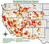
I can't share the reports themselves but with each report Land Matters includes heat maps to give a visual aid in identifying the most active areas. Special Report #1 presented Placer Mining Claims that were closed within the last three years AND were more than 30 years old when they were closed. This was an interesting report because claims that are more than 30 years old are usually considered valuable and worth keeping. Not your average exploratory claim that lasts for a year or two. Useful information for the clever prospector.

Here's the heat map from Special Report #1. The map shows the areas with the most closed Placer claims as a deep red and then fewer claims density are shaded down from lighter red to pale yellow. The smaller black lines are county borders to give you a little better idea where the activity is taking place.

View attachment 1241267

Although this map is nowhere near as detailed as the full report it does give a good view of where the claims changed and even potentially tracks areas of higher mineralization and claims interest. The report itself shows each claim, 14 data fields per claim and a direct link to the BLM records for the claim.

The Special Report #2 is similar to the first but deals with 30 year lode claims. Neither of these Special Reports or the twice monthly Closed Claims Reports could be created from LR2000 information.

We are working on Special Report #3 now and I'm really excited about what that's going to reveal. The things Land Matters can do with our huge databases is truly amazing. I'll have more info on that report when we get closer to releasing it.

Heavy Pans
 

OP
OP
Clay Diggins

Clay Diggins

Silver Member
Nov 14, 2010
4,885
14,258
The Great Southwest
Primary Interest:
Prospecting
This is the red spot I was thinking of...

Ah... that was from Special Report #1. That's an entirely different report than Special Report #3.

Wait until we get to Special Report #42. By then we will have you totally confused. :dontknow:

Heavy Pans Jeff, sleep well. :thumbsup:
 

Jeff95531

Silver Member
Feb 10, 2013
2,625
4,094
Deep in the redwoods of the TRUE Northern CA
Detector(s) used
Teknetics Alpha 2000
Primary Interest:
Prospecting
cb.jpg
 

OP
OP
Clay Diggins

Clay Diggins

Silver Member
Nov 14, 2010
4,885
14,258
The Great Southwest
Primary Interest:
Prospecting
Sage Grouse Proposed Mineral Withdrawal added to Mining Claims Maps

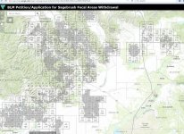
I've added the Sage Grouse proposed Mineral Withdrawal display to the Mining Claims Maps for the five affected states. It's a separate layer you will have to turn on to see.

This map has been heavily requested. Check it out while you can since the BLM is known for disappearing maps without notice.

This map was not easy to find. It's not going to be easy to use either because the BLM is serving it up in a light dirt color that blends with just about every base map layer. Now is a good time to learn to use the transparency tool found by right clicking the layer you want to change the transparency on.

The affected States Mining Claim Maps are linked here:

Oregon

Idaho

Wyoming

Nevada

Utah

Here's the description of the Map information from the BLM. As you can see the map isn't accurate because the boundaries of the final withdrawal won't be decided until after it's passed. :BangHead:

The areas recommended for locatable mineral withdrawal dataset were compiled from the Bureau of Land Management (BLM) National Greater Sage-Grouse (GRSG) Conservation Strategy, which includes Environmental Impact Statements (EIS) for the revision or amendment of 98 Forest Service and BLM land use plans. Data reflect the areas of Sagebrush Focal Areas, a subset of GRSG Priority Habitat Management Areas, which are recommended for withdrawal from the Mining Law of 1872 in the Records of Decisions for the Approved Resource Management Plans and Amendments.

DISCLAIMER: No warranty is made by the BLM or FS for the use of this data. The GIS data included on this page is intended for broad planning purposes only and should not be solely relied upon for any decision making. Accuracy of the GIS is limited to the accuracy of the data available to create these layers at the time of this project. The information contained on the map is used to generally locate and identify the lands that are proposed for withdrawal in the sage brush focal areas and is for reference purposes only. They should not be construed or used as legal descriptions. Detailed maps and legal descriptions will be developed at a later date.

We are trying to figure out a way to get a list of the affected claims from this information. If we succeed we will make a list and share it on the Land Matters website.

Please pass these maps around. It's your Land and it Matters.

Heavy Pans
 

SpecJet

Jr. Member
May 8, 2013
83
105
So Cal
Primary Interest:
Prospecting
Clay, those special reports 1,2 & 3 maps are absolutely awesome.
I see a claims subscription in my very near future.
 

winners58

Bronze Member
Apr 4, 2013
1,729
4,058
Oregon
Primary Interest:
All Treasure Hunting
BLM is saying this proposed withdraw “Sagebrush Focal Areas” is less than 10,000,000 acres as indicated in the grey areas
but they are also talking "buffer zones" and in their map they show the gray area but have blocked out the whole township
if you add up the townships (23040 acres per) they come to 19,000,000 acres.
So if you have a mining claim even close you should be concerned.

sagebrush.jpg
 

Last edited:

goldenIrishman

Silver Member
Feb 28, 2013
3,465
6,152
Golden Valley Arid-Zona
Detector(s) used
Fisher / Gold Bug AND the MK-VII eyeballs
Primary Interest:
Other
I'm just glad those areas don't come anywhere near me! They've been grabbing up any and all land they can think of an excuse for. Is this open to challenge? I noticed that they cited an Environmental Impact STATEMENT instead of the more costly STUDY. Wouldn't that fail to meet the requirements as stated by law for closure of public lands?
 

OP
OP
Clay Diggins

Clay Diggins

Silver Member
Nov 14, 2010
4,885
14,258
The Great Southwest
Primary Interest:
Prospecting
Land Matters Server Upgraded!

The Land Matters internet server has been struggling with it's workload the last few weeks. It's not unusual for 1,000 or more maps to be requested per hour. Our monthly files downloaded now exceed 80 Gigabytes. :occasion14:

Essentially the incredible popularity of Land Matters has been pushing our server memory to the limit for about 90% of every day!

Despite Land Matters popularity the bills barely get paid each month. Servers and bandwidth are expensive and even though we are a volunteer run nonprofit there have been times I've had to donate more than my time and materials to keep the servers up and running. It's tough having to reach in my pocket after donating my time all month but Land Matters is an educational non profit I really believe in.

Our recently introduced Membership program along with a generous sponsorship from Rob's Detectors and several anonymous donors have finally allowed us to expand our server memory and space. We just now added double the memory and disk space on the Land Matters servers! That means some scary new monthly bills but it really needed to happen.

In testing the new server configuration I'm seeing map creation speeds in line with Google maps. No more waiting forever for an aerial view to load. Testing the current Land Matters aerial layer we are now seeing speeds equivalent to the best mapping systems on the web.

With the addition of double the server disk space we will now be able to proceed with bringing you several new projects that have been waiting for the upgrade. I'll be posting more details on those new projects as we bring them online.

I want to thank everyone who has contributed to the success of Land Matters. Whether you have found the site useful and to enjoy it or have contributed to it's support you are an integral part of Land Matters continued success. :thumbsup:

Heavy Pans
 

Jeff95531

Silver Member
Feb 10, 2013
2,625
4,094
Deep in the redwoods of the TRUE Northern CA
Detector(s) used
Teknetics Alpha 2000
Primary Interest:
Prospecting
Barry...I use, have used and enjoy learning on Land Matters Maps just about daily. The claims advantage benefit is nice but the info can be found if you don't mind working for it (you made me do it ya know :evil6:). My biggest beef IMHO would be I can't save a location I've researched and found. In a perfect world, I'd like to save it to my favorites and come directly back to it. BUT if it now works twice as fast...well then that would be a non issue. Really/truly want to thank you for your dedication and the site. My wish goes out to you and yours for only the best in 2016 and beyond. :thumbsup:
 

OP
OP
Clay Diggins

Clay Diggins

Silver Member
Nov 14, 2010
4,885
14,258
The Great Southwest
Primary Interest:
Prospecting
Barry...I use, have used and enjoy learning on Land Matters Maps just about daily. The claims advantage benefit is nice but the info can be found if you don't mind working for it (you made me do it ya know :evil6:). Really/truly want to thank you for your dedication and the site. My wish goes out to you and yours for only the best in 2016 and beyond. :thumbsup:

Thanks Jeff, I hoping 2016 is your big nuggets year! :thumbsup:

You won't be able to find the information on the Claims Advantage reports by yourself. The LR2000 doesn't have the information no matter how much you work. The Claims Advantage twice monthly reports and the Special Reports are time and space based. The LR2000 can't provide that type of comparison because all the entries are backdated.

The most recent Special Report #3 shows all Placer claims that meet three criteria:
1. They are CLOSED.
2. They were held for 20 years or more before they were closed.
3. The quarter Section in which they were located is now unclaimed.

In other words the report shows open ground that was held under claim for a long time and is now unclaimed. You know - go where gold has been found in the past.

The twice monthly reports show all the claims that were closed in the last half month. You can't find that information on the LR2000 because all those claim closures are backdated to the date of the effective closure. All the LR2000 claims show the same closed date no matter when they were actually closed.

We do this type of reporting by making copies of the master BLM database in Denver twice a month. That's about 1.5 Gb downloaded every two weeks. We then make comparisons to find the differences between the database copies. The dates on the claims reports don't tell us anything but the differences over time reveal all kinds of stuff.

Besides revealing the new lands possibly open to location in the twice monthly claims reports there are all kinds of things this analysis method allows us to see. This is not just about claims, there's interesting stuff that comes up looking at time and space differences.

Ultimately we will be showing patterns of how money and claim location and closures vary by State as well as the priorities of each State BLM office. Besides keeping an eye on our public servants and providing information that will be useful for those looking to keep their claims or make new ones the obvious benefit to the prospector to be the first to know about new areas possibly opening up is just the tip of the iceberg. There's lots more possible with these reports as we build information over time.

Here's another heat map to show where those 18,835 closed yet still unclaimed areas are in Special Report #3.

MapSpecial#3.jpg

And here's a LINK to an interactive map showing the same open areas.

Heavy Pans
 

Jeff95531

Silver Member
Feb 10, 2013
2,625
4,094
Deep in the redwoods of the TRUE Northern CA
Detector(s) used
Teknetics Alpha 2000
Primary Interest:
Prospecting
Thanks for the clearing that up Clay. By "make it work" what I've been doing is going to CA mining claims and then add historical claims. Then narrow it down to my area and start researching for AU, then how good, how old, how long ago. There's a LOT of old and non AU claims in my area and I've been looking at em one by one. The research eventually put me on what appears to be good ground yesterday for Area # 2 for 2016. A quick pan at home and surprise! Color! It was visible but all under 40 and I was still about a mile and a half from the mine. And yep, I marked the spot!
 

OP
OP
Clay Diggins

Clay Diggins

Silver Member
Nov 14, 2010
4,885
14,258
The Great Southwest
Primary Interest:
Prospecting
Thanks for the clearing that up Clay. By "make it work" what I've been doing is going to CA mining claims and then add historical claims. Then narrow it down to my area and start researching for AU, then how good, how old, how long ago. There's a LOT of old and non AU claims in my area and I've been looking at em one by one. The research eventually put me on what appears to be good ground yesterday for Area # 2 for 2016. A quick pan at home and surprise! Color! It was visible but all under 40 and I was still about a mile and a half from the mine. And yep, I marked the spot!

Excellent!

Sounds like you are well on your way to a golden 2016. :thumbsup:

Heavy Pans
 

motohed

Hero Member
Dec 27, 2015
670
499
RI
Detector(s) used
XP DEUS , AND OLDER GARRETT'S
Primary Interest:
All Treasure Hunting
I noticed there is'nt anything on New Hampshire , is it in the works , or nothing available ? Thanks Scott
 

OP
OP
Clay Diggins

Clay Diggins

Silver Member
Nov 14, 2010
4,885
14,258
The Great Southwest
Primary Interest:
Prospecting
Gosh I'm sorry Scott. New Hampshire is so small it got lost under Iowa somehow when I was doing the map puzzle code. :laughing7:

I will get the New Hampshire Geology Map up and running in the next few days. I see you are in Rhode Island and that piece is missing too. :icon_scratch: I'll get both maps displaying soon.

Let me know if there's more stuff you need. Land Matters is all about the users and if we know what you want and it's doable we will make it available. :thumbsup:

Heavy Pans
 

Top Member Reactions

Users who are viewing this thread

Top