Need Some Help With Reading the Land

Huelten

Full Member
Nov 22, 2013
101
77
Oregon
Primary Interest:
Prospecting
So ive realized that finding good information on locating gold that is not within a stream bed is very hard to find. Ive asked on this forum before and the main answer i get is "get to bedrock" which is easier said than done. Ive dug for hours straight and never found bedrock in certain areas. Anyways ive gotten access to a new claim which claims to be virgin ground. a little background on this spot could help get my answer so this area is part of a 15-2o mile canyon which was dredged in the old days by a bucket line dredge. The dredge stopped about a mile before this claim and this area was never mined. This claim is near the end of the canyon and then the landscape changes to flatlands. A guy i met on this forum let me dig around on a claim of his about 5 miles further up the road in this same canyon and i found good color up high in the hills with next to nothing down low and in the stream bed. What im asking is for some good advice that does not consist of "get to bedrock" and "sample areas". I understand those are obvious responses to the question. Im more after good solid knowledge on how to read the land and identify spots which are MOST LIKELY to be good areas. Any thoughts?

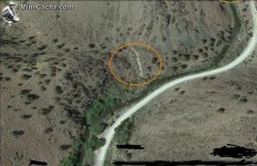
forgot to add info, i think the red circle looks like a good area, am i on the right track?

Thanks!

the spot.png
 

Last edited:
Upvote 0

DizzyDigger

Gold Member
Dec 9, 2012
5,832
11,573
Concrete, WA
Detector(s) used
Nokta FoRs Gold, a Gold Cube, 2 Keene Sluices and Lord only knows how many pans....not to mention a load of other gear my wife still doesn't know about!
Primary Interest:
Prospecting
Howdy Huelten:

My experience is somewhere between Greenhorn and Old Sourdough
(makes me an Old Sour Greenhorn?), but I did take a good look at the
image and marked a few spots (in blue) that I would want to sample.

the spot.jpg

That sloughed off hillside on the middle left side of claim is one I'd
certainly want to have a look at for evidence of gold bearing materials.
If there was a good deal of quartz and iron the base of that hillside
where it meets the wash would most definitely be on the top of my
list to check out.

Other than that I can only say that "Gold is where you find it".
 

OP
OP
H

Huelten

Full Member
Nov 22, 2013
101
77
Oregon
Primary Interest:
Prospecting
That is the same spot i was thinking looked good but ive had bad luck with similar areas in the past so i was worried my thought process was off regarding those wash areas. Im gonna be headed down there this weekend to stick a shovel in the ground as winter is yet to truly hit my area so prospecting is still alive and well
 

DDancer

Bronze Member
Mar 25, 2014
2,339
2,002
Traveling US to work
Detector(s) used
Current Equinox 600
Past Whites DFX Garret GTI 2500 and others
Prospecting Minelab GPZ 7000
Past SD 2100 GP 3000 (retired)
Primary Interest:
All Treasure Hunting
Old Sour Greenhorn has some excellent suggestions. The dredge may have stopped due to overburden being to extensive lower down in the canyon~ a thought~
My only addition to where you may want to dig is to draw a line along the Sour line on the left of the picture to the base of the bend heading up in the picture and maybe jog a little to the left up the canyon to the left. Hope you'll let us know in a month or so.
 

Reed Lukens

Silver Member
Jan 1, 2013
2,653
5,418
Congres, AZ/ former California Outlawed Gold Miner
Detector(s) used
Tesoro Vaquero, Whites MXT, Vsat, GMT, 5900Di Pro, Minelab GPX 5000, GPXtreme, 2200SD, Excalibur 1000!
Primary Interest:
All Treasure Hunting
Also I would put the pic and questions on the Dowsing Forum and see what the map dowsers have to say about everything including depth.
 

OP
OP
H

Huelten

Full Member
Nov 22, 2013
101
77
Oregon
Primary Interest:
Prospecting
Well what exactly is Dowsing? i'm a relative greenhorn and i've never heard of dowsing
 

jog

Bronze Member
Nov 28, 2008
1,364
682
Tillamook Oregon
Detector(s) used
Whites MXT / GMT
Primary Interest:
All Treasure Hunting
If it were me I would take a pan (If there is water) and start testing that drainage you have circled in red. It apears there was a lot of interest by a large mining company and also a lot of old mines up at the headwaters of that draw, also I wouldn't worry about going off the claim to the south, it's all BLM & it looks like there are no active claims anywhere in that same draw to the south. I have been told by a very good source that the bigger gold has allmost allways been found on that side of the river a few miles up stream.
 

OP
OP
H

Huelten

Full Member
Nov 22, 2013
101
77
Oregon
Primary Interest:
Prospecting
Jog: Do you have any information as to how deep bedrock can be in that area? I know its a vague question but i know you have some good experience in that particular area. Im just saying that you should drag your big fancy trommel down here and pass on some knowledge :thumbsup:
 

Bejay

Bronze Member
Mar 10, 2014
1,026
2,530
Central Oregon Coast
Detector(s) used
Whites GMT
Garret fully underwater
Primary Interest:
Prospecting
There is no doubt the need to get to bedrock is critical. The old timers would actually tunnel in just above bedrock........but this is very troublesome in ancient river gravels. But it was a MUST to get the gold. I am familiar seeing such historical methods used. Other than that method, the current method is to use big equipment and remove the overburden, and process it; if it has enough values to warrant the processing. In many cases it does not.

In the recent past a good friend (recently deceased) acquired a large claim that had good values on bedrock, but the extensive gravel overburden failed to meet the values test. He opened up large areas of bedrock by excavating the overburden. Very good values were on the bedrock and it was obvious the old timers knew where the gold was. Tunneling deep into ancient river gravels is not my expertise.

The Burnt River area in eastern Oregon is typical of this problem.

Bejay
 

goldenIrishman

Silver Member
Feb 28, 2013
3,465
6,152
Golden Valley Arid-Zona
Detector(s) used
Fisher / Gold Bug AND the MK-VII eyeballs
Primary Interest:
Other
Any type of tunneling like Bejay mentioned will require extensive shoring to keep the overburden from coming down on top of your head. Please remember to mine in a safe manner and follow all safety requirements for your given situation. No amount of gold is worth loosing your life over! About a year or so back we had a local rockhound lost to a cave-in while digging in a bank for geodes. He had dug in too far, had no supporting structure and had not removed the overburden and everything came down on top of him. Don't become yet another statistic!
 

jog

Bronze Member
Nov 28, 2008
1,364
682
Tillamook Oregon
Detector(s) used
Whites MXT / GMT
Primary Interest:
All Treasure Hunting
Huelten
From what I have been told the average depth of the overburden on that particular river can be from 10 to 30 foot in the main channel, I would have to say if you were in a narrow pinch point my guess is that it would be less than if you were in a wide flat area.I dropped in on my claim a couple years ago and only went 2 foot before hitting a limestone rib running across the channel. The good gold is found on bedrock in this particular canyon. I don't know if you have a metal detector but if you do I would work my way up those dry ravines. I know you have a high banker and a spot I would check near the water would be the area I have circled. It looks like this is a spot where the run off from the ravine is cutting through the higher ground on the back side of the bend. Just my two cents worth....
 

Attachments

  • Overburdan.jpg
    Overburdan.jpg
    62.3 KB · Views: 99

jog

Bronze Member
Nov 28, 2008
1,364
682
Tillamook Oregon
Detector(s) used
Whites MXT / GMT
Primary Interest:
All Treasure Hunting
Looking at it closer you could start on the back side of # one and chase the bedrock towards the river, it appears to be very narrow there and bedrock may be much less, If you look at # two it appears to be a bedrock ridge running back towards the the main channel and possibly cuts accross the dry ravine, even looks like some iron stains in the rock ridge. That may be a good spot and the overburdon may be much less there too. Then number # three where the dry wash has been cutting through the main river gravels.
 

Attachments

  • Overburden #2.jpg
    Overburden #2.jpg
    63.6 KB · Views: 81

Top Member Reactions

Users who are viewing this thread

Top