Help with reading a master title plat?

mofugly13

Full Member
Jan 30, 2015
198
184
San Francisco, Ca
Primary Interest:
Prospecting
Hi all. I have been very interested in staking my own gold claim for a long time. Lately, I've really begun to research what it takes, and at this point I have a pretty good idea of what I need to do. I have been using Geocommunicator, LR2000, and the Land Matters mapping tool to get the ball rolling. I have an area that I'm interested in, primarily because a friend married into a family with a claim in this same area, and I have been there. But I am having a hard time deciphering the plat for the area to figure out if it's open to mineral discovery. I found a 'how to read a MTP' on some gov't website, but it isn't entirely clear to me. The areas I am looking at have USFS 'tracts' in them, and these are shown on the MTP with the notation 'MS' which I understand to mean 'Mineral Survey'. But that's all I got. How do I tell if a section is open to discovery?

Attached is a clip I captured from the MTP I am looking at. The NW and SW quarters of section 12 is what I'm interested in:
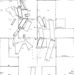
MTP clip.jpg
 

Upvote 0

dredgeman

Sr. Member
Feb 14, 2013
340
249
Primary Interest:
All Treasure Hunting
Call BLM State office with the township range section and meridian. Know what quarter or area as in SWSE .

Ask them if it is open to mineral entry. They are usually correct. You have to send paperwork to them anyhow.

As to the plat map. The properties that are or once were private are marked
 

Bejay

Bronze Member
Mar 10, 2014
1,026
2,530
Central Oregon Coast
Detector(s) used
Whites GMT
Garret fully underwater
Primary Interest:
Prospecting
I read your query and offer the following for consideration: You say mineral discovery....and I believe you mean those public lands open to "mineral entry". With that knowledge of open to "mineral entry", and the knowledge of "land yet to be claimed" you could have the potential to make "mineral discovery". Such "discovery" is necessary to locate and file a mineral claim.

In your query you might want to mention if you are interested in making either a "lode" or "placer" location.

When I use Land Matters mapping I go to ownership to first see if the land is public land; either administered by the USFS or BLM. Once that is known I can make some determination if other locatable claims exist within that BLM or USFS admin lands. That obvious determination allows me to pursue further.

With such mapping determination I can pursue further. Both "Land Records" (public land office...usually county) as well as the BLM file records which can offer more precise answers.

Hope this gives you some clarification so that an answer can be offered.....as I found your query a little confusing.

Bejay
 

Clay Diggins

Silver Member
Nov 14, 2010
4,883
14,247
The Great Southwest
Primary Interest:
Prospecting
Welcome to TNet mofugly13.

There is an MTP tutorial on Land Matters that should help you understand all that gobbledygoop.

The Mineral Survey may, or may not, have been granted a patent. If not it is probably still public land.

It doesn't look like these Mineral Surveys have any effect on the land status there. You need to get the MTP supplements and history and look up that Section/Quarter Section to know for sure. The Sections repeat throughout those tables so don't think you are done until you've looked up all the cases for that Section. Between those and the MTP you should be able to see if there are any restrictions in the area you are researching.

Each Mineral Survey has it's own number. That number allows you to look up the actual plat and survey that was done. You can usually get the mineral survey map and description by searching the General Land Office where you got the MTP. Although those surveys don't change the land status, if they weren't patented, they can be a big help determining where mineralization has already been discovered. They show strikes , shafts, mine components, houses, stables and assay buildings as well as public roads that were used to get around or through the area.

Land matters has three videos and a study guide to help you get deeper into the workings of the BLM and GLO record systems. This is the training course for BLM land status personal.

Heavy Pans
 

Clay Diggins

Silver Member
Nov 14, 2010
4,883
14,247
The Great Southwest
Primary Interest:
Prospecting
Looking a bit closer at your MTP it appears your area of interest may be in a power withdrawal. That doesn't mean you won't be able to make a claim there but you will have to put that in your Location notice. Make sure that you clearly state on the first page that the claim is being located under Public Law 359.

The BLM then has 60 days to notify you if there are any restrictions on your location. After the 60 days if you don't hear from them (you usually won't) you can go ahead and occupy your claim as usual. You may have to fill out a form in the future.

Heavy Pans
 

OP
OP
M

mofugly13

Full Member
Jan 30, 2015
198
184
San Francisco, Ca
Primary Interest:
Prospecting
Thanks for the responses guys. Bejay, thanks for setting me straight on the terms, I appreciate you helping me to sound like I know a little about what I'm talking about. Clay, there was one post you made in the "Prospector's Research tools" thread, #136, that was one of the most helpful things I've read so far about the process of staking a claim. Thanks guys for taking the time to help a newbie like me. Sounds like my next step should be along the lines of contacting BLM and finding out the actual status of the land I'm interested in.
 

jog

Bronze Member
Nov 28, 2008
1,364
682
Tillamook Oregon
Detector(s) used
Whites MXT / GMT
Primary Interest:
All Treasure Hunting
I contacted my local BLM several years ago and asked for a copy of the Plat Map cheat sheet, they sent me several large copies for free which I had laminated.
This will tell you what all the abbreviations mean when looking at a plat map, also it will define the different boundary lines also such as a patent line versus a public land open for mineral entry.
 

jog

Bronze Member
Nov 28, 2008
1,364
682
Tillamook Oregon
Detector(s) used
Whites MXT / GMT
Primary Interest:
All Treasure Hunting
"YEP" That is one handy little tool to have, everyone should have one.
 

Bejay

Bronze Member
Mar 10, 2014
1,026
2,530
Central Oregon Coast
Detector(s) used
Whites GMT
Garret fully underwater
Primary Interest:
Prospecting
As you noted on the response Clay gave per the Land Matters cite....such an example is afforded the individual inquiring. Land Matters has gathered (is gathering) all such land information (still more to come) and placing it in one place: Land Matters . Thanks for the query mofugly13 as I even learned some new things and can approach such issues differently.

Bejay
 

minerrick

Sr. Member
Feb 18, 2013
277
357
Detector(s) used
Makro Racer
Primary Interest:
All Treasure Hunting
Welcome to TNet mofugly13.


The Mineral Survey may, or may not, have been granted a patent. If not it is probably still public land.

Each Mineral Survey has it's own number. That number allows you to look up the actual plat and survey that was done. You can usually get the mineral survey map and description by searching the General Land Office where you got the MTP. Although those surveys don't change the land status, if they weren't patented, they can be a big help determining where mineralization has already been discovered. They show strikes , shafts, mine components, houses, stables and assay buildings as well as public roads that were used to get around or through the area.


Heavy Pans

So Clay, where does one find the actual mineral survey map? I went to the GLO site and clicked on the mineral survey page and loaded the info for California Township/range etc (not knowing "who or when" the survey was done") and came up with a big fat zero other than a zoomable featurless map showing the quarter section online only. I contacted via email the GLO people and the response I got was something to the effect that they don't have the CA mineral survey maps online. So what's a person to do? I am interested in the history of these properties. I see people who are displaying these mineral survey plats online, so I know they get them SOMEWHERE.....any clues?
 

Clay Diggins

Silver Member
Nov 14, 2010
4,883
14,247
The Great Southwest
Primary Interest:
Prospecting
Not all of the California Surveys have been scanned for the Plats. California usually lags behind the other States in completing these projects. You can usually find the ones that aren't scanned yet by ordering them from the State BLM office.

You can get their patent and index number from the Master Title Plat or from the Control Document Index (CDI). It may take them a while to scan them and send you a copy (paper) but the cost is minimal.

Heavy Pans
 

Top Member Reactions

Users who are viewing this thread

Latest Discussions

Top