The greenhorn prospectors question thread...

mofugly13

Full Member
Jan 30, 2015
198
184
San Francisco, Ca
Primary Interest:
Prospecting
As a true greenhorn, very wet behind the ears, I have some questions that may sound dumb to those of you with claim staking and mining experience. However, throughout my life I have found that often the dumb question never gets asked, and therefore answered, because nobody wants to sound dumb. They tell you in Marine Corps Boot Camp that "the only dumb question is the one not asked." Ha! fine and dandy until someone asks a dumb question! Anyway, I do believe that the only dumb question is the one not asked, and often when I ask the dumb question, others present perk up for the answer, because no one wanted to ask a dumb question. So I'll start this thread with a dumb question(s), and surely, will add more as I progress toward staking a mining claim of my own.

First off, I am familiar with the PLSS system and the naming or identifying Townships, Ranges, Sections and Subdivisions of Sections.

I bought the book "Location and Validity of Mining Claims and Sites in California" from BLM. I have just started reading it, mainly paying attention to the information about placer claims. On p. 45, under the section Placer Mining Claims and Notices there is a part that states:

"All placer mining claims must conform as nearly as possible with the US System of Public Land Surveys and the rectangular subdivisions of these surveys, whether the locations are on surveyed or unsurveyed land."

Assuming the Area I want to claim is open for mineral entry and that there are no existing valid claims, do my claim boundaries need to form a rectangle or square?

What about an 'L' shaped claim that is no more than 20 Acres in size?

Or, would I need to file multiple claims of rectangular/square shape to make an 'L' shaped claim?

Do borders of my claim need to be precisely on the survey lines of sections, 1/4 sections, aliquots etc.?

Thanks for the help guys. I wish I had found this site way back when I first got interested in making a gold claim, so much information.
 

Last edited:
Upvote 0

Hefty1

Bronze Member
Dec 5, 2010
1,702
1,477
Yes you have the answer...

"All placer mining claims must conform as nearly as possible with the US System of Public Land Surveys and the rectangular subdivisions of these surveys, whether the locations are on surveyed or unsurveyed land."

Smallest square being 2.5 ac.
 

Last edited:
OP
OP
M

mofugly13

Full Member
Jan 30, 2015
198
184
San Francisco, Ca
Primary Interest:
Prospecting
So, a claim will either be either rectangular shaped, or square shaped. If I have a 2 1/2, or 10 acre claim, it must be a square. A 5 or 20 acre claim must be a rectangle. If I wanted to claim a bend in a river, I would most likely need multiple claims?
 

Hemisteve

Sr. Member
Feb 21, 2008
459
123
N. Nevada
Detector(s) used
Goldmaster V/Sat and MXT
Primary Interest:
All Treasure Hunting
Whoops! I had it wrong.
 

Last edited:

Bonaro

Hero Member
Aug 9, 2004
977
2,213
Olympia WA
Detector(s) used
Minelab Xterra 70, Minelab SD 2200d, 2.5", 3", 4"and several Keene 5" production dredges, Knelson Centrifuge, Gold screw automatic panner
Primary Interest:
Prospecting
You should first review the Master Title Plat on the BLM website or through the LR2000
Land Records and Master Title Plats - Bureau of Land Management California

It will show you exactly if the spot you are considering is surveyed. If it has been surveyed then your description might look like ( S 1/2 of lot 7 ) and the lot has already been defined for you by whoever surveyed it. You simply need to work your way out from the nearest benchmark on the ground.
If it is unsurveyed then you will need to create a map that includes distances and direction from the point of discovery to the corners and identify that map as being in the Aliquot part. This part gets real muddy. The BLM website can help clear this up

Oh yeah...and the rules change from state to state :icon_scratch:
 

goldenIrishman

Silver Member
Feb 28, 2013
3,465
6,152
Golden Valley Arid-Zona
Detector(s) used
Fisher / Gold Bug AND the MK-VII eyeballs
Primary Interest:
Other
Oh yeah...and the rules change from state to state :icon_scratch:

Yeah... This is something that can really mess people up at times. They look up "how to file a claim" on the web and don't notice that it's for a different state so it doesn't apply to them.

Here in Arizona we are REQUIRED to have our corners marked, monument in place etc. to have a valid claim. Not so in California and I'm not sure what the requirements are in other states. Even though California does not require claim markers in many areas, it's always nice to have them up and remove any doubt of where the boundaries of your claim are for other prospectors/miners. Call it a courtesy that can keep you from getting high graded. The signs are available at most mining suppliers and are not expensive.

IMHO... We as miners need to work together and do our best to get everyone on the same page. Since the majority of claims are made on Federal Lands, shouldn't the Feds be the ones making the rules on how a claim has to be marked? That way a miner that is on vacation in California from say Colorado would know exactly what to look for if he was wanting to do some prospecting.
 

bobw53

Hero Member
Oct 23, 2014
522
1,132
Hatch, New Mexico
Primary Interest:
All Treasure Hunting
Yeah... This is something that can really mess people up at times. They look up "how to file a claim" on the web and don't notice that it's for a different state so it doesn't apply to them.

Here in Arizona we are REQUIRED to have our corners marked, monument in place etc.

It is weird... Here in New Mexico, all 4 corners have to be marked, and unlike the link to the Nevada BLM up there, markers have to be 4 feet tall, not 3 feet... Paperwork only needs to be
in one corner, but the other markers have to have directions on how to get to the paperwork (or you can just put the paperwork in all of them)...

Monument of discovery, and the discovery itself was removed in 1981... Something to do with previous discoverys and new methods that allow you to know there are minerals there,
with out actually having to go dig them up... And the monument of discovery wasn't another marker, or a pile of rocks, supposed to be a hole 10 feet wide, 10 feet deep, and 10 feet long...
And I guess cows were falling into them, it was also rather difficult in a place where bedrock was close to the surface... The ones I've seen are about 5x5 and only a couple of feet deep,
with the dirt and rocks piled up around the outside...

I just thought that was strange, and proves the point of different rules in different states... Which makes no sense to me since it is on federal land.
 

goldenIrishman

Silver Member
Feb 28, 2013
3,465
6,152
Golden Valley Arid-Zona
Detector(s) used
Fisher / Gold Bug AND the MK-VII eyeballs
Primary Interest:
Other
10X10X10 hole as a monument of discovery? That sounds about STUPID!!! how is a person supposed to see it at a distance?

Here the monument has to have something like an empty P-nut butter jar attached to it that has a coy of the claim map / notice of discovery. When I mount mine I have it so the opening is facing downward to keep any rain out. Every time I go out to my claim(s) I make sure I have copies of the monument paperwork with me so I can replace it if needed.
 

bobw53

Hero Member
Oct 23, 2014
522
1,132
Hatch, New Mexico
Primary Interest:
All Treasure Hunting
10X10X10 hole as a monument of discovery? That sounds about STUPID!!! how is a person supposed to see it at a distance?

You've obviously never crossed the border into New Mexico, that is probably the least stupid thing that has happened here.. :tongue3:

I would guess that that law came about because somebody was running around claiming up everything with intentions of doing nothing but selling the claims...
They probably all got together, realized the guy was a scum bag, and decided that if he wanted to claim up the entire state, he was going to have to work
really hard for it.

Unfortunately that kind of history (the interesting small local stuff) probably was never recorded, and the only thing we will ever know about it is an old piece of
legislation.
 

Clay Diggins

Silver Member
Nov 14, 2010
4,883
14,251
The Great Southwest
Primary Interest:
Prospecting
New Mexico Location requirements:

New Mexico Codes Chapter 69 - Mines. Article 3 - Mining Locations and Operations

69-3-1. Mining claim location and posting notice.

A. Any person or persons desiring to locate a mining claim upon a vein or lode of quartz or other rock in place bearing gold, silver, cinnabar, lead, tin, copper or other valuable deposit must distinctly mark the location on the ground by four substantial posts or monuments, one at each corner of the claim, so that its boundaries may be readily traced, and post in some conspicuous place on such location, a notice in writing stating thereon the name or names of the locator or locators and his or their intention to locate the mining claim, giving a description thereof by reference to some natural object or permanent monument as will identify the claim.

B. The locator shall, at the time of making location of any placer mining claim, cause a notice of the location to be placed at a designated corner of the claim so located, stating the name of the claim, the purpose and the kind of material for which the claim is located, the name of the person locating same, and, if located upon surveyed lands, the notice shall contain a description of the claim by its legal subdivision. If upon unsurveyed lands, the notice shall contain a description of the claim by metes and bounds, with reference to some known object or monument. And whether upon surveyed or unsurveyed lands, each corner of the claim shall be marked by a post at least four feet high, securely set in the ground, or by a substantial stone monument.

C. The date of posting of written notice on the location pursuant to Subsection A or B of this section is deemed to be the date of location. Within ninety days after the date of location, the locator of a lode or placer claim shall file for record in the office of the clerk of the county in which the claim is located, a written notice of location for the claim containing:

(1) the name of the claim;

(2) the name and current mailing address of the owner of the claim;

(3) an identification of the claim as either lode or placer;

(4) the date of location;

(5) a description reciting, to the extent possible, the section in which the claim is located and the approximate location of all or any part of the claim by quarter section. In addition, there shall be furnished the section, township and range; and

(6) either a topographic map published by the U.S. geological survey or copy of such map on which there shall be depicted the location of the claim, or a narrative or sketch describing the claim with reference by appropriate tie to some topographic, hydrographic or man-made feature. Such map, narrative description or sketch shall set forth the boundaries and positions of the individual claim with such accuracy as will allow the claim to be identified and located on the ground and shall be no larger than eight and one-half inches by fourteen inches. More than one claim may be shown on a single map or described in a single narrative or sketch if they are located in the same general area, so long as the individual claims are clearly identified.

D. Nothing in the requirement for a map or description found in this section shall require the locator or locators of a claim to employ a professional surveyor or engineer.


69-3-10. [Boundary posts.]

The surface boundaries of mining claims heerafter [hereafter] located shall be marked by four substantial posts or monuments, one at each corner of such claim, so as to distinctly mark the claim on the ground, so that its boundaries can be readily traced, and shall otherwise conform to Section 69-3-1 NMSA 1978.

69-3-11. Relocation.

The relocation of any mining ground, which is subject to relocation, shall be made in the same way as an original location is required by law to be made.

69-3-13. [Alteration, removal or destruction of location marks or notice; penalty.]

Any person who shall take down, remove, alter or destroy any stake, post, monument or notice of location upon any mining claim without the consent of the owner or owners thereof shall be deemed guilty of a misdemeanor, and on conviction, shall be punished by a fine not exceeding one hundred dollars [($100)] or by imprisonment in the county jail not exceeding six months, or by both such fine and imprisonment.

69-3-14. [Defacing or changing location notice; penalty; correction of errors.]

Any person or persons, or the manager, officer, agent or employe of any person, firm, corporation or association, who shall in any manner alter, deface or change the location notice of any mining claim in this state, located under the laws of the United States and of this state, or any local regulations in force in the district wherein such claim is situated, thereby in any manner affecting the rights of any person, firm or corporation, to such claim or location, or the land covered thereby, shall be deemed guilty of a misdemeanor, and upon conviction thereof before any court of competent jurisdiction, shall be fined in a sum not less than one hundred dollars [($100)], nor more than five hundred dollars [($500)], or imprisoned in the county jail for not less than sixty days, nor more than one year, or by both such fine and imprisonment, in the discretion of the court trying the case. Nothing herein contained shall affect the rights of such locator or locators, and his or their assigns, to correct errors in such notice and file amended location notices as provided in Section 69-3-12 NMSA 1978, and the laws of the United States: provided, such change shall not affect or change the date of such location notice, or affect the rights of any other person.

Heavy Pans
 

bobw53

Hero Member
Oct 23, 2014
522
1,132
Hatch, New Mexico
Primary Interest:
All Treasure Hunting
A. Any person or persons desiring to locate a mining claim upon a vein or lode of quartz or other rock in place bearing gold, silver, cinnabar, lead, tin, copper or other valuable deposit must distinctly mark the location on the ground by four substantial posts or monuments, one at each corner of the claim, so that its boundaries may be readily traced, and post in some conspicuous place on such location, a notice in writing stating thereon the name or names of the locator or locators and his or their intention to locate the mining claim, giving a description thereof by reference to some natural object or permanent monument as will identify the claim.

It doesn't say it can't be the corner...

And some interesting reading.

http://lawschool.unm.edu/nrj/volumes/22/2/09_matthews_newmexico.pdf
 

OP
OP
M

mofugly13

Full Member
Jan 30, 2015
198
184
San Francisco, Ca
Primary Interest:
Prospecting
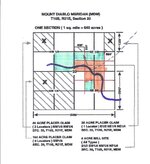
Here is what I'd like to do. Make a claim in the shape of the orange highlighted area. Kind of shaped like an arrowhead, but easily named using the 1/4 aliquot system. This would be a 15 acre claim. Would I be able to make a single claim with these boundaries? Or, would I need to file two separate rectangular shaped claims which would be indicated by the orange and blue highlighted areas?

Scan_Pic0021.jpg
 

Reed Lukens

Silver Member
Jan 1, 2013
2,653
5,418
Congres, AZ/ former California Outlawed Gold Miner
Detector(s) used
Tesoro Vaquero, Whites MXT, Vsat, GMT, 5900Di Pro, Minelab GPX 5000, GPXtreme, 2200SD, Excalibur 1000!
Primary Interest:
All Treasure Hunting
You can make it like that but if you have an access road outside of the boundary then it's best to get it inside of the boundaries
 

OP
OP
M

mofugly13

Full Member
Jan 30, 2015
198
184
San Francisco, Ca
Primary Interest:
Prospecting
Yes you can do it that way mofugly13 but what you are showing in orange would be a 60 acre claim - not a 15 acre claim.

Heavy Pans

Clay, you're right, I did draw a 60 acre claim. I meant to subdivide those quarters yet again into 2 1/2 acre lots, but I got ahead of myself in my haste to make a drawing and get it scanned and posted, DOH! Those 10 acre squares should be 2 1/2 acre squares, laid out in the same configuration. Imagine that the drawing is of a quarter section instead of a full section, and that is what I was going for.

I'd like to post up the drawing I made of the actual area I'm interested in, which I did draw correctly divided down to 1/4, 1/4, 1/4 sections... but I don't wanna give anyone any ideas!

Reed, there is, or was an access road in the area. I don't think it extends as far as the map shows anymore. I really need to get myself into this area and have a look-see. It's been 15 years since I've been.
 

Clay Diggins

Silver Member
Nov 14, 2010
4,883
14,251
The Great Southwest
Primary Interest:
Prospecting
That form of claim would be supported with 60 acres.

The smallest regular subdivision contemplated is 5 acres and that size is iffy if there are no lots.

You will have to locate by metes and bounds tied to the survey if you want to locate in that shape. I imagine you will get an objection from the BLM quoting the Snowflake Placer non-suit from 1912. :BangHead:

Heavy Pans
 

Reed Lukens

Silver Member
Jan 1, 2013
2,653
5,418
Congres, AZ/ former California Outlawed Gold Miner
Detector(s) used
Tesoro Vaquero, Whites MXT, Vsat, GMT, 5900Di Pro, Minelab GPX 5000, GPXtreme, 2200SD, Excalibur 1000!
Primary Interest:
All Treasure Hunting
Best thing to do is take a blown up map into BLM and then they will help you draw it in and configure the location. What I do is blow up the 160 acre section and print it out to fit a standard piece of paper. This way it has the section number right in the middle. Or you can go just over the ¼ section in the same way to show the number in the corner
 

Last edited:

Top Member Reactions

Users who are viewing this thread

Top