Claim boundaries question

Strebs

Jr. Member
May 16, 2014
88
127
New Mexico
Primary Interest:
Prospecting
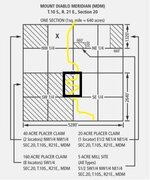
aliquotparts51.jpg Ok, I've been doing a lot of research... Found open ground in a pretty good area. But what i cannot find out for sure if i can make a claim like the black box to include two different 1/4 sections. It is placer claim and trying to get as much river front as possible. Any help in the matter is greatly appreciated.
 

Upvote 0

ratled

Hero Member
Feb 18, 2014
950
2,396
Primary Interest:
All Treasure Hunting
"the E 1/2 of the NE 1/4 and the w 1/2 of the NW1/4 " of of those sections. Look at the 20 acre example and do that twice in the description with "and"

ratled
 

Last edited:

Clay Diggins

Silver Member
Nov 14, 2010
4,885
14,258
The Great Southwest
Primary Interest:
Prospecting
That's an easy one. :thumbsup:

Just one sentence:

Those 40 acres comprising the E 1/2 of the NE of the SW and the W 1/2 of the NW of the SE of T10S R21E Section 20 Mount Diablo Meridian, Situated in XXX Mining District, XXX County, XXX State.

Watch out for lots and other irregular portions of the survey. Those quarter quarters might be L3 or something or it could be a short section. That will need to be factored into your location.

Heavy Pans
 

Underburden

Sr. Member
Mar 22, 2012
484
1,125
Idaho
Detector(s) used
Gold Hog Stream Sluice
Primary Interest:
Prospecting
If you're married, file it with your spouse since it will take 2 locators for a 40 acre claim. If you're single, file it with someone you really, really, really trust !!!
Bob
 

goldenIrishman

Silver Member
Feb 28, 2013
3,465
6,152
Golden Valley Arid-Zona
Detector(s) used
Fisher / Gold Bug AND the MK-VII eyeballs
Primary Interest:
Other
Those short sections and partial townships have always struck me as strange. I just can't understand the justification for them as shown on the maps. It almost seems like they started surveying on both the north and south ends and met in the middle and had to adjust. I know they were done as an adjustment of some sort but the rhyme and reason of it eludes me.
 

SLNugget

Sr. Member
Sep 25, 2013
262
232
Morristown, AZ
Detector(s) used
Gold Bug Pro
Primary Interest:
Prospecting
You could also file it as 2 20 acre claims with no need for 2 claimants. A bit more costly but not much.
 

Underburden

Sr. Member
Mar 22, 2012
484
1,125
Idaho
Detector(s) used
Gold Hog Stream Sluice
Primary Interest:
Prospecting
GoldenIrishman
Hard to lay out these square sections on a round earth...something has to bend somewhere :laughing7:
 

uglymailman

Bronze Member
Feb 3, 2010
1,266
1,463
There is actually a correction factor for the curvature of the earth when land surveying. Here in the midwest it's about a foot in 100 miles measured n/s. The reason for "corrections" is accumulation of error. Second order work is to be within 1 foot in 5000 ft. If you are on flat ground this is pretty easy to accomplish. The rougher the ground the more error. The county to the south of me has some 1 mile by 1 1/2 mile sections (supposed to be 1x1 mile). Some of those original surveyors were very accurate. Some had a hard time.
 

goldenIrishman

Silver Member
Feb 28, 2013
3,465
6,152
Golden Valley Arid-Zona
Detector(s) used
Fisher / Gold Bug AND the MK-VII eyeballs
Primary Interest:
Other
LOL... And some KNEW they were working for the government so the "That's good enough"(for government work) factor came into play as well.
 

2cmorau

Bronze Member
Nov 8, 2010
1,608
1,294
Camptonville, CA
Detector(s) used
GMT&GM3 Whites MXT Pro, Shadow X5, Fisher 1280, OMG and the TDI
Primary Interest:
Prospecting
speaking of boundarys need to thank Clay and Bejay. with the boundary dispute i was having with another claim owner i discoverd 10 acres of open river, woohoo
thanks guys, for taken the time out of your day to help answer my e-mail, it has been a fun journey
 

OP
OP
S

Strebs

Jr. Member
May 16, 2014
88
127
New Mexico
Primary Interest:
Prospecting
Thanks guys for the help, cleared up that question. Also when staking the poles you just find the end of the quadrants via gps or is there an easier way? Thanks again!
 

Hoser John

Gold Member
Mar 22, 2003
5,854
6,721
Redding,Calif.
Primary Interest:
All Treasure Hunting
Legal description of dark black claim is---E 1/2 OF THE NE 1/4 OF THE SW 1/4 AND W 1/2 OF THE NW 1/4 OF THE SE 1/4-TOTAL 40 acres. Close to $400 total at the recorders and BLM costs now sic sic sic-. The Dept of Interior is currently trying to kill the whole claim process as they purport that we miners have too many rights that interferes with their plans sic sic sic. BLM.gov has a great book for new claims that is free online--John
 

Last edited:

goldenIrishman

Silver Member
Feb 28, 2013
3,465
6,152
Golden Valley Arid-Zona
Detector(s) used
Fisher / Gold Bug AND the MK-VII eyeballs
Primary Interest:
Other
John.... Got any more info on these plans? If we don't know what is going on we can't fight their Bovine Scientology.
 

Hoser John

Gold Member
Mar 22, 2003
5,854
6,721
Redding,Calif.
Primary Interest:
All Treasure Hunting
This-and all forums-carry the new closures,restrictions and withdrawls daily. The budget post I did here a week ago--sound familiar as the BUDGET was how they killed dredging in kalif----has the info on trashing all our claim rights and turning them into leases with royalities on top of more taxes which leads to 10X the property taxes also due to increased production-hense the mineral possery rights more valuable. TICK TOCK...TICK TOCK...sic sic sic-John
 

goldenIrishman

Silver Member
Feb 28, 2013
3,465
6,152
Golden Valley Arid-Zona
Detector(s) used
Fisher / Gold Bug AND the MK-VII eyeballs
Primary Interest:
Other
Ahhhh Ok. I remember reading that one but didn't know it was the same issue you mentioned above. thanks man!
 

Maitland

Full Member
Mar 15, 2010
172
159
Black Hills, South Dakota
Detector(s) used
White's Silver Eagle, Fisher Gold Bug 2
Primary Interest:
Prospecting
Calling all experts!

I have two questions that are somewhat-related to this thread that I'm a bit curious about and have been wondering for some time. I use Land Matters and the LR2000 quite a bit to do claim research on what's available in my area, my problem is: I can't seem to find out specifically what part of a section is claimed other than just the initial quarter section of that section. For example, it's easy to find out if the NE 1/4 of section 20 is claimed or not... but say there's a 20-acre claim on section 20, I can't seem to find out if it could be the east half of the southwest quarter of the northeast (SWNE) quarter of section 20 or if could be the south half of the southeast corner of the northeast (SENE) quarter of section 20 (or any other variation of the NE 1/4 section of section 20 for that matter). Am I doing something wrong, or is this all of the information that is available online... just the initial 1/4 section and no other more-detailed information? It ought to be in the LR2000 I would think, but I guess it wouldn't surprise me if the the feds are too lazy to put that information into the BLM serial number/lead file reports available on the LR2000. I've been wondering this for a very long time, and it would be extremely helpful to know what part of a quarter of a quarter section a claim is in, but I can't seem to find this out anywhere!

My second question is: I know you can claim odd-shaped pieces of FS/BLM land, but what on earth do you use for a legal description? Say it's 3 acres, do you just use what quarter of a quarter of a section it's in? Also, what if it's a triangle or some type of polygon shape, I suppose you can have three "corner markers", or five or more if need be? I know it's a dumb question, but I've been eyeballing a piece of BLM land to check out for this-coming summer and this is what it looks like (so likewise I'm curious how the description would be for claiming it):
kqvvlO7.jpg

Thanks to Land Matters for the map!
 

Last edited:

Clay Diggins

Silver Member
Nov 14, 2010
4,885
14,258
The Great Southwest
Primary Interest:
Prospecting
Hey Maitland, turn on the PLSS layer on the map while you are zoomed into that area. You will find that the area is described as a Lot. Something like L3 will designate that portion. A Lot number is a proper division of the public lands. They are called Lots instead of quarter quarters because they are not square or not evenly sized. You can use the Lot number along with the 1/4 section and Section to give the legal land description.

When you need to make an irregular claim (Lots are not irregular) you need to do so by metes and bounds (direction and distance). That involves a permanent land feature, a compass and accurate measurement.

The BLM doesn't even show the claims to the 1/4 section! (Check out this explanation) They are not responsible for mapping claims - the locator is. Each Locator makes a public record with the County Recorder. That is the proper place to look for claims maps, not the BLM.

Land Matters has several tutorials on how to describe land divisions as well as determining land status. I would suggest you start with the three part video and study guide titled Legal Description and Land Status. :thumbsup:

Heavy Pans
 

Maitland

Full Member
Mar 15, 2010
172
159
Black Hills, South Dakota
Detector(s) used
White's Silver Eagle, Fisher Gold Bug 2
Primary Interest:
Prospecting
Hi Clay, yeah, I've had the PLSS layer turned on, but I don't see anything designated with "L#", just "NENE, NENW, SESW," etc., so I assume those are what the lots are that you are referring to. Is there any way you could give a made-up description of irregular claim? Just curious what the format looks like... chances are I've seen irregular claim legal descriptions somewhere before but I can't think of any, is that where they use terminology like "due east 300' of the intersections of roads ____ and ____" or something along those lines?

Well, that solves my question about the vague legal descriptions of claims used by the BLM. So I guess if there's a spot of good ground that I'm curious about possibly claiming, the next best place to go would be the county register of deeds (we don't have a recorder's office here) to see where pre-existing claims lie within the "lots" of that quarter section, and hopefully the locators of the claims gave good information to the register of deeds.

I'm using a computer at a relative's house right now, but when I get some free time at home I will check out the video and study guide you speak of. Thanks!
 

Last edited:

Clay Diggins

Silver Member
Nov 14, 2010
4,885
14,258
The Great Southwest
Primary Interest:
Prospecting
If there is no Lot designation you will find the legal land description on the Master Title Plat or the Plat Supplements. We should have those ready for South Dakota later this week. You can copy the description from there. :thumbsup:

Here is a example of a simple metes and bounds description tied to a survey corner:

The locality of this claim with reference to some natural object or permanent monument is as follows: The SW corner No.1 of the claim is located 1320 ft North and 1817 ft East of the SW corner of Section 42, T 99N R 99W.

This claim runs from the SW corner No.1, 817 ft in a NW 27 deg direction to corner No.2, then
830 ft in a NW 45 deg direction to the NW corner No.3, then 1114 ft in an East direction to the NE corner No. 4,
then 1320 ft in a South direction to the SE corner No.5, then 163 ft in a West direction to the place of
beginning.

Metes and bounds can get a lot more complex than that but the basic idea is to describe where one corner of the claim sits in relation to a known permanent object that can easily be found. Survey corners and Mineral Survey monuments are the most common but it could also be a prominent rock or natural feature (not a tree or something that can die or wash away). From that corner describe the compass direction and distance to the next corner. Rinse and repeat until you arrive back at the starting point.

Heavy Pans
 

Clay Diggins

Silver Member
Nov 14, 2010
4,885
14,258
The Great Southwest
Primary Interest:
Prospecting
Hey Maitland. I've built the Land Matters South Dakota Land Status map so you can download the MTP for that area and get the boundary description. You will find land management and PLSS layers on there too so you can do your research from one map. :thumbsup:

Heavy Pans
 

Top Member Reactions

Users who are viewing this thread

Latest Discussions

Top