Drone Mapping of Placer Gold Claims

mulletator

Jr. Member
May 16, 2015
98
118
British Columbia
Primary Interest:
Prospecting
This last weekend I mapped a placer gold claim with a drone. The drone that was used is not one of those cheap multi-rotor type that you see everywhere this is a real mapping unit. Lots of eye candy was produced but the goal of this mission is to locate ancient river channels and get a detailed bird's eye view of the claim.

Here is a write up about the drone mission: Drone Mapping of Placer Claim on Fraser River

Here's a sample of the 3D model that was produced.
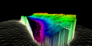
GM_Wire.png

The potential uses drones in placer mining are huge. It was previously not possible for a small placer miner to pay for aerial photography let alone 3D photogrammetry. With advances in technology and software the price has come down to a reasonable level and the imagery is unmatched.
 

Upvote 0

fowledup

Silver Member
Jul 21, 2013
2,757
5,162
Northern California
Detector(s) used
Whites GMT V/SAT
Primary Interest:
Prospecting
Very cool, how does heavy timber effect the mapping quality as far as terrain is concerned? You don't have to be real specific but if you don't mind what would something like that cost for say a 100 acre area, <1k, >1k?
 

OP
OP
M

mulletator

Jr. Member
May 16, 2015
98
118
British Columbia
Primary Interest:
Prospecting
Hey fowledup, the heavy timber will affect the true terrain map of the ground. If the trees are very dense you will basically get a map of the tree canopy instead of the ground. If they are not as dense you will get the ground but the trees will also be part of the map. If its sparse you can remove the trees in processing but its hard.

LiDAR is really effective of seeing through trees and can produce a product called "Bare Earth". LiDAR works by classifying returns and can differentiate between vegetation, water, and the ground. However LiDAR is extremely expensive and not small enough to fit on drones yet. I actually worked for a company developing a large drone (14 ft wingspan, 100cc gas engine) to do LiDAR surveys among other things. Before someone jumps in here and says it is available on drones. That is only partially true. There are some small form LiDAR units available but they can only produce a 3D scan without classification. That is no better than photogrammetry that can be done with high res imagery.

As for costs, I charge $4 per acre for this kind of mapping. So 100 acres would cost $400 plus mob/demob.
 

Bonaro

Hero Member
Aug 9, 2004
977
2,213
Olympia WA
Detector(s) used
Minelab Xterra 70, Minelab SD 2200d, 2.5", 3", 4"and several Keene 5" production dredges, Knelson Centrifuge, Gold screw automatic panner
Primary Interest:
Prospecting
that $80 for 20 acre placer claim. I would buy that
 

fowledup

Silver Member
Jul 21, 2013
2,757
5,162
Northern California
Detector(s) used
Whites GMT V/SAT
Primary Interest:
Prospecting
Thank you for the very informative info, will keep my eye on this technology for sure (this is the kind of techno advancements I love), neat stuff and a reasonable price to boot. Let us know if you ever come down this way and are looking to line up a few jobs to pay for the trip, I'm sure there are a ton of folks that would love to have a map of their claim like that!
 

OP
OP
M

mulletator

Jr. Member
May 16, 2015
98
118
British Columbia
Primary Interest:
Prospecting
Hey guys, yeah I'd have to charge more than $80 for a flight. For large areas like the one I posted which is over 1000 acres I don't charge extra for processing. Also mob/demob would be billed as well. Still it can be done for a very reasonable cost.

In Canada I am a legal drone operator with liability insurance, pilot training and I meet all the Transport Canada conditions. I'm not sure how the regulations work in the United States.
 

Terry Soloman

Gold Member
May 28, 2010
19,421
30,104
White Plains, New York
🥇 Banner finds
1
🏆 Honorable Mentions:
1
Detector(s) used
Nokta Makro Legend// Pulsedive// Minelab GPZ 7000// Vanquish 540// Minelab Pro Find 35// Dune Kraken Sandscoop// Grave Digger Tools Tombstone shovel & Sidekick digger// Bunk's Hermit Pick
Primary Interest:
Metal Detecting
You should be a charter member of the site to promote your business, which is pretty cool.
 

G.I.B.

Gold Member
Feb 23, 2007
7,187
8,537
North Central Florida
🏆 Honorable Mentions:
1
Detector(s) used
CTX 3030 / GTI 2500 / Infinium LS / Tesoro Sand Shark / 1 Garrett Pro-pointer / 1 Carrot / Vibra Probe 580 (out on loan) / Lesche M85 / Mark1 MOD1 EyeBall
Primary Interest:
Other
Hello mulletator. I'm curious as to what LiDAR system you are using.

I'm presently flying the Leica, ALS 40-100 series, Optech ALTM 3100 and Gemini, some SHOALS systems, Bathy stuff and so forth.

Just for discussion, we fly leaf off/snow off for most of our work which produces a Bare Earth DEM and run it through ARCGIS (and the like) software. I'm getting sub meter resolution, but it's not cheap.

What kind of DEM resolution is your system producing? How about accuracy?

There are LiDAR units on Drones. They are not affordable to the general public however.
 

Clay Diggins

Silver Member
Nov 14, 2010
4,885
14,257
The Great Southwest
Primary Interest:
Prospecting
I've done a lot of this work with 3D modeling for mining companies. Without considerable post processing and stuff like terraflow and 3D drilling data it doesn't have a lot of use directly for mining. Most of the final results go into project promotion and advertising ultimately. Potential investors are fascinated by the graphics like you presented above. :thumbsup:

I'm wondering how you handle the locational data with drones. What type of ground stations do you use for a 1,000 acre composite? Do you cross reference with CORS? Does Canada even have a CORS type system? It looks like with overlaps your scan resolution is around 600 foot (just guessing)?

How about sensor size? The sensors have to be a lot smaller how is that affecting scan resolution. Don't the number of runs go up considerably compared to traditional remote sensing? What is the final working resolution of your project?

I've found that for good extrapolated terrain analysis an area much greater than the target is needed. Things like slope stability analysis and flood projection need a lot of base data outside the final presentation to bring up the accuracy. How much larger is your footprint than the information you present in the final model?

Drones could make things less expensive for the miner. Most of the Majors could care less about the expense but many of the Juniors are under financing stress right now so if drones could be shown to be as accurate as traditional remote sensing they may eventually have a place in the industry. For now the lack of good Lidar is a show stopper. Putting ground and aerial crews in place for Lidar is already the big expense and time factor on most projects.

Do drones have any advantage in inclement weather? If they can handle, wind, rain, cloud cover better that real helicopters that might be a bonus. One of our biggest problems is scheduling ground crews and helicopters around their booking schedule and the weather.

Thanks for sharing your model with us. It brought up a lot of questions about drones and mapping. I hope to see more of your results in the future. :thumbsup:

Heavy Pans
 

fowledup

Silver Member
Jul 21, 2013
2,757
5,162
Northern California
Detector(s) used
Whites GMT V/SAT
Primary Interest:
Prospecting
Where was this stuff when I was 16 and trying to figure out what to do with myself for the rest of my life? For discussion purposes what courses or schooling would a person wishing to pursue a career in this take to learn this?
 

G.I.B.

Gold Member
Feb 23, 2007
7,187
8,537
North Central Florida
🏆 Honorable Mentions:
1
Detector(s) used
CTX 3030 / GTI 2500 / Infinium LS / Tesoro Sand Shark / 1 Garrett Pro-pointer / 1 Carrot / Vibra Probe 580 (out on loan) / Lesche M85 / Mark1 MOD1 EyeBall
Primary Interest:
Other
Clay, I read his link. It's not LiDAR, it's Ortho's and they probably don't have any Metadata, so no CORS stations. It's basic photo stitching and using that to extrapolate elevation data, maybe with some old STS-64 LITE data points.

My LiDAR work requires a 1 sec CORS within 30nm, and if there isn't one, I use a portable base station.

I see three 1 second stations on the east side of Canada. Nothing west of Manitoba. His imagery may not require this resolution however.

Screen Shot 2015-07-10 at 6.17.22 PM.png
 

G.I.B.

Gold Member
Feb 23, 2007
7,187
8,537
North Central Florida
🏆 Honorable Mentions:
1
Detector(s) used
CTX 3030 / GTI 2500 / Infinium LS / Tesoro Sand Shark / 1 Garrett Pro-pointer / 1 Carrot / Vibra Probe 580 (out on loan) / Lesche M85 / Mark1 MOD1 EyeBall
Primary Interest:
Other
Where was this stuff when I was 16 and trying to figure out what to do with myself for the rest of my life? For discussion purposes what courses or schooling would a person wishing to pursue a career in this take to learn this?

GIS, heres a LINK to get you started.
 

OP
OP
M

mulletator

Jr. Member
May 16, 2015
98
118
British Columbia
Primary Interest:
Prospecting
Hey GIB, I'm not using LiDAR. This is work is done with photography. Each photo location and attitude (pitch, yaw, roll) of the aircraft is logged during flight and tied to each photo. The post processing software does the heavy lifting and computes all the photogrammetry. No ground control points were used in that survey. They can be used where higher accuracy is required and will produce an even better result.

There are LiDAR units on drones but none of them produce classified data. I worked on a drone project from 2011-2013 with a large drone and we were using a Velodyne LiDAR. That was the smallest at that time. The result was decent but without classification you can't produce a bare earth so there's no point. With non-classifying LiDAR sensors you only get a point cloud which can be done with photogrammetry to similar accuracy. In the next few years sensors will come out that can compete with the large LiDAR units and that will be the next game changer. Drones have an advantage by flying at low altitude (less than 500ft) so you don't need a super high res sensor.

I've never used CORS. When we need GCPs we collect them ourselves on site with an RTK rover. A larger area is surveyed than what is usable for DEM generation. Photogrammetry requires multiple overlapping photos to calculate positions.

As for resolution the orthomosaic has a resolution of 7.3 cm/pix, the DEM is 29.2 cm/pix and point density of 11.7 points/m2. That was good for this job. Higher resolution can be achieved by setting a lower altitude and tighter line spacing and by using RTK control points.
 

Clay Diggins

Silver Member
Nov 14, 2010
4,885
14,257
The Great Southwest
Primary Interest:
Prospecting
I'm new to these methods mulletator so please forgive me if this has already been answered. Where does you DEM data come from? Is it really extrapolated from the flight path itself? How do you get a resolution of 29.2 cm/pix?

I see in your model that there is a lot of steep slope. Is this from your bump extrapolation of the DEM or is this real world 1 to 1?

Thanks for your responses. :thumbsup:

Heavy Pans
 

OP
OP
M

mulletator

Jr. Member
May 16, 2015
98
118
British Columbia
Primary Interest:
Prospecting
Hey Clay,

The 3D data is produced by a technique called stereophotogrammetry. Basically the software picks out common points in overlapping photos and reconstructs the light ray back to the camera position. In the case that I presented above over 35,000 tie points were used. It is important to know the camera position in 3D space as well as the direction it is facing. The GPS and IMU onboard the drone record that information. In post processing software is where the photogrammetry takes place. There's a little more to the process but that's the gist of it.

The resolution of the DEM is always less than the original photos. I started out with photos of 4cm/pix that meaning that each pixel represents a 4cm x 4cm block of ground. I'm not sure what you mean by bump extrapolation but I think there was a slight vertical exaggeration in that fancy photo that I posted. The real area is pretty steep though.
 

Top Member Reactions

Users who are viewing this thread

Top