Goggle Earth claim ploting software

ratled

Hero Member
Feb 18, 2014
950
2,396
Primary Interest:
All Treasure Hunting
After seeing Bonaro's thread on staking (http://www.treasurenet.com/forums/gold-prospecting/479456-claim-staking-question.html) and some of the talk on plotting I thought I would pass on the software I use for plotting claims since it works with township & range. I use Earth Point http://www.earthpoint.us/Townships.aspx

What's nice is you can use the trial version now and again if you only do a few. It's good for plotting your claim, the neighbors property and where other claims are. In Goggle Earth you just zoom in on your claim or the area you are looking at and in a few minutes it will lay a grid over the area.

I hope this helps some

ratled
 

Last edited:
Upvote 0
OP
OP
ratled

ratled

Hero Member
Feb 18, 2014
950
2,396
Primary Interest:
All Treasure Hunting
Here is a sample of a random area out in gold country. The purple is township and range and the green is section. It is clickable.
ratled


Clay Diggins

Silver Member
Nov 14, 2010
4,885
14,258
The Great Southwest
Primary Interest:
Prospecting
Good lord! Those people are charging for the old PLSS?

It's free to all at MetzgarWillard. Download the free kml. There is some other FREE cool stuff there too so look around.

Click the free downloaded kml/kmz and start up Google Earth. You will see the Meridians, Townships, Ranges, Sections and quarter quarter Sections all the time for free.

It's not accurate, it's not current and with Google Earth it's not in the right spot but it's the same as what Earth Point is charging for. :BangHead:

This is public information. It's available for everyone in a bunch of different formats and it's no longer used by the BLM, Forest Service, any government agency or Land Matters. It's been replaced and "upgraded" to the theoretically more accurate CAD NSDI several years ago.

Heavy Pans
 

Hemisteve

Sr. Member
Feb 21, 2008
459
123
N. Nevada
Detector(s) used
Goldmaster V/Sat and MXT
Primary Interest:
All Treasure Hunting
I agree with Clay. Download the "kml" and turn it on or off as needed for research. It should only be used to "get you in the general area" as it can be off by a lot. A good example is our claim. It is on a section line and the PLSS shows it to be 275' farther west than it actually is.
 

Bonaro

Hero Member
Aug 9, 2004
977
2,213
Olympia WA
Detector(s) used
Minelab Xterra 70, Minelab SD 2200d, 2.5", 3", 4"and several Keene 5" production dredges, Knelson Centrifuge, Gold screw automatic panner
Primary Interest:
Prospecting
I already use the metzgar-willard kml file in my google earth and it does a good job of overlaying PLSS info
 

goldenIrishman

Silver Member
Feb 28, 2013
3,465
6,152
Golden Valley Arid-Zona
Detector(s) used
Fisher / Gold Bug AND the MK-VII eyeballs
Primary Interest:
Other
Well knowing how "off" Google Earth is I wouldn't trust it for more than looking at a general area. Claims are filed by data from the PLSS system in most cases and you can have accurate PLSS information from almost every USGS topo map out there. You can download them from the USGS site for free.

NOTE: Be sure that you check that the maps have the PLSS info included in/on them. The USGS did some that they didn't include that info on. I guess they had enough complaints that they put the PLSS information back in/on them. If you look at the files in Adobe Reader, you may not see the PLSS info displayed on the map. Look on the left side and find the layers controls. Open up the "MAP FRAME" component and click on the PLSS box to turn it on. If it's not there... you got the version of the map they left it out of.

Call me "Old School" but I'll stick to a map and a good compass. No batteries to go dead....
 

OP
OP
ratled

ratled

Hero Member
Feb 18, 2014
950
2,396
Primary Interest:
All Treasure Hunting
I have found it to be accurate to within a foot on our claims. It has been very useful when neighboring private property owners claim I am on their property and show them the county tax assessor plot maps and a picture like in the sample. By using the trial version I don't need to subscribe.

It works well for me and I find it easy to use

ratled
 

Clay Diggins

Silver Member
Nov 14, 2010
4,885
14,258
The Great Southwest
Primary Interest:
Prospecting
As a professional cartographer I can guarantee you there is no such thing as 1 foot accuracy available unless you are employing a very expensive surveyor using the latest equipment for a site specific, on the ground, survey.

I could go on to explain the differences between accuracy, resolution and precision but why bore folks that really don't care?

Here's the meat in terms of public use of the word accuracy:

Aerial photography at it's best will be accurate to 9 foot. You aren't working with 9 foot accuracy (see below).

Public land surveys as presented on the internet - including county assessors maps will be accurate to 9 foot at best. The ones on Google aren't 9 foot accurate. Most public land surveys don't actually exist - they are extrapolations from an real survey pin that may be many miles away. Error in those many cases goes way up.

Topo maps are accurate to 40 foot at best. Often much less.

"Commercial" GPS units are 98% accurate to 30 foot (Commercial units are the ones you are using hand held in the field). With WAAS enabled and an 11 satellite lock in the dry southwest air with no trees or clouds and 4 minutes of static settle time GPS can be 9 foot accurate 98% of the time. Go north, damp air, no settle time, trees, clouds - not so much.

Now let's add in Google images to the equation. To find out how accurate Google maps are we need to go to the source. Google itself has already cleared this up for us. Direct from Google:

"How accurate is Google Earth mapping?

Google makes no claims as to the accuracy of the coordinates in Google Earth. These are provided for entertainment only and should not be used for any navigational or other purpose requiring any accuracy whatsoever.

Our imagery varies from sub-meter resolution in major cities to 15 meter resolution for most of the earth's surface, with a global base resolution of 1KM. Since our database is constantly being updated, we cannot state a specific resolution for any geographic region.

Google acquires imagery from many different sources with many different file formats, projections and spectral characteristics. All imagery sources are fused into a single global database with a proprietary format that has been developed for the specific purpose of streaming to our client software."


Seems Google doesn't make any claims to accuracy at all. "Entertainment only" pretty much sums up the Google Earth map philosophy. If you understood how Google makes their maps you would understand why they won't consider them to be any more than entertainment.

Now lets add all these errors up and realize that if the best aerials are 9 foot off in one direction and the GPS is off 30 foot in another direction and the PLSS is off 40 foot in another direction and Google doesn't know where it is - do I need to draw you a map? :laughing7:

There is a lot to this mapping stuff that the public doesn't see. There is a huge amount of politics involved in marking ones territory. Seldom do the County Assessor and the USGS agree on where a property line is. Many neighbors can't agree on where a 100 foot property line is so don't expect accuracy on a map to be better than on the ground.

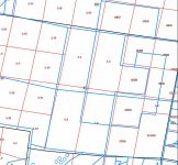
Here's a real world example of the difference between the PLSS and the County Assessors maps in a random section on the American River. I could show you many many more of these from virtually anywhere in the US. Many are much worse. In this map the black lines are the PLSS Sections the red are the aliquots and lots and the blue lines are where the County Assessor thinks the survey lines are. Their disagreement varies from a few feet to several hundred feet.

plats.jpg

So if the County Assessor and the official USGS survey can't agree... accuracy? ???

I deal with these issues every day. I can guarantee you I make some of the most accurate maps available. My goal is one foot accuracy and I will honestly say the closest I've ever come to that standard across an entire map is about 30 foot. Sure I can show you where a single survey pin, GPS and my map all agree within 9 inches but a whole map? Not a chance. Not a chance for me, Google or the County Assessor. If a map is off 30 foot in any single place the real accuracy of that map is only 30 foot - not the 9 inches accuracy found in one spot.

Think of it this way. A really good painter paints a picture of your friend. You look at the painting and say to yourself "that looks just like my friend". But is it just like your friend? Could you use the picture to take to a doctor and get a diagnosis? Could you send the painting to a court to represent your friend? Could the painting move in with you and do the dishes and pay the rent?

The painting is not the same as your friend. A map is not the same as your position on the ground. You can't trust your health, property or human relationships to either a painting or a map.

Maps are incredibly useful if you understand their limitations. I love maps and mapping but I'm always acutely aware of their limitations. Get the best maps you can and use them to get you where you need to go. Once you are where you are going the facts on the ground trump even the best of maps. If you want to know where you are look around you. :thumbsup:

Heavy Pans
 

OP
OP
ratled

ratled

Hero Member
Feb 18, 2014
950
2,396
Primary Interest:
All Treasure Hunting
Clay, a couple of questions if you don't mind while I high jack my own thread - one of our neighboring "private properties" is a patented claim, I have a copy of the patent, and is listed as "H.E.S XXXX" do you know what H.E.S.stands for? Also, the boarding patented claim is called "Mineral Sample XXXX" on the patent. Are these just the names of the patents or they something else like a type patent?

TIA

ratled
 

wmpwi

Jr. Member
Sep 24, 2015
53
54
Grand Rapids, MI
Detector(s) used
AT Pro
Primary Interest:
Metal Detecting
I've seen nothing else today as illuminating as Clay's narrative on mapping. Thanks for that.

Sent from my XT1080 using Tapatalk
 

Clay Diggins

Silver Member
Nov 14, 2010
4,885
14,258
The Great Southwest
Primary Interest:
Prospecting
Clay, a couple of questions if you don't mind while I high jack my own thread - one of our neighboring "private properties" is a patented claim, I have a copy of the patent, and is listed as "H.E.S XXXX" do you know what H.E.S.stands for? Also, the boarding patented claim is called "Mineral Sample XXXX" on the patent. Are these just the names of the patents or they something else like a type patent?

TIA

ratled

There's a lot on a patent ratled so I can't be sure exactly what you are referring to but if your H.E.S XXXX appears as the name of the patented claim that just what it is - the name. They certainly aren't any code. The very nature of a patent is that all the details are clearly explained in agonizing detail.

Unusual names were common on old patents. Often they were anagrams or secret signs for an organization the patentee belonged to. Sometimes you can track down the history and get an understanding of why they called it something strange. More often it remains a puzzle. :dontknow:

Heavy Pans
 

OP
OP
ratled

ratled

Hero Member
Feb 18, 2014
950
2,396
Primary Interest:
All Treasure Hunting
There's a lot on a patent ratled so I can't be sure exactly what you are referring to but if your H.E.S XXXX appears as the name of the patented claim that just what it is - the name. They certainly aren't any code. The very nature of a patent is that all the details are clearly explained in agonizing detail.

Unusual names were common on old patents. Often they were anagrams or secret signs for an organization the patentee belonged to. Sometimes you can track down the history and get an understanding of why they called it something strange. More often it remains a puzzle. :dontknow:

Heavy Pans

Thanks, we have never seen another H.E.S. and haven't been able to find much other than the patent. I wasn't sure on the mineral sample either but I guess you have to call them something.

Thanks again

ratled
 

delnorter

Hero Member
Oct 28, 2008
907
2,300
Northern California
Primary Interest:
All Treasure Hunting
I'm not sure in this case but usually HES refers to Homestead Entry Surveys. They were metes and bounds survey of homestead applications in the early 1900s, usually in unsurveyed areas within Forest Service lands. The HES identification may have been incorporated into the Patent Claim identity. I forget a lot of what I used to know

One of the original corners of a HES I found, while performing a retracement survey here in Del Norte County, Ca., was a large natural, native stone monument with the letters HES and appropriate numbers scribed into it. Really cool.

Mike
 

Clay Diggins

Silver Member
Nov 14, 2010
4,885
14,258
The Great Southwest
Primary Interest:
Prospecting
I'm not sure in this case but usually HES refers to Homestead Entry Surveys. They were metes and bounds survey of homestead applications in the early 1900s, usually in unsurveyed areas within Forest Service lands. The HES identification may have been incorporated into the Patent Claim identity. I forget a lot of what I used to know

One of the original corners of a HES I found, while performing a retracement survey here in Del Norte County, Ca., was a large natural, native stone monument with the letters HES and appropriate numbers scribed into it. Really cool.

Mike
Thanks Mike! That makes sense. :thumbsup:

I don't think I've ever seen a metes and bounds Homestead entry. Usually it's quarter sections out here.

Good info. Now I'll keep an eye out for them.

Heavy Pans
 

OP
OP
ratled

ratled

Hero Member
Feb 18, 2014
950
2,396
Primary Interest:
All Treasure Hunting
I'm not sure in this case but usually HES refers to Homestead Entry Surveys. They were metes and bounds survey of homestead applications in the early 1900s, usually in unsurveyed areas within Forest Service lands. The HES identification may have been incorporated into the Patent Claim identity. I forget a lot of what I used to know

One of the original corners of a HES I found, while performing a retracement survey here in Del Norte County, Ca., was a large natural, native stone monument with the letters HES and appropriate numbers scribed into it. Really cool.

Mike


THANKS Mike. That gives more to look for. I'll go ahead and re-read the patent and see of there was something we missed. That time frame fits for us

ratled
 

delnorter

Hero Member
Oct 28, 2008
907
2,300
Northern California
Primary Interest:
All Treasure Hunting
Right on guys. The whole surveying history is really interesting. A lot of very smart people put a lot of thought and effort into our land laws. It was and still is some of our most sacred foundations of rights in this country.

Well, it's 5:00 AM and I'm off to my last hunting camp outs this season. I think there's a nice buck out there with my name on it.

Mike
 

Clay Diggins

Silver Member
Nov 14, 2010
4,885
14,258
The Great Southwest
Primary Interest:
Prospecting
Right on guys. The whole surveying history is really interesting. A lot of very smart people put a lot of thought and effort into our land laws. It was and still is some of our most sacred foundations of rights in this country.

Well, it's 5:00 AM and I'm off to my last hunting camp outs this season. I think there's a nice buck out there with my name on it.

Mike

Wishing you a clean kill and a short hump out Mike. :thumbsup:
 

goldog

Hero Member
Sep 25, 2012
923
987
Tujunga, CA
Detector(s) used
Bazooka Gold Trap, A-51, Gold Pan
Primary Interest:
Prospecting
We're about to place claim posts and this info is really helpful. I'm not extremely concerned in my case. Ours is the only active claim for miles.

There is a nearby benchmark indicated on topo maps. Would this help to confirm GPS readings?
 

Top Member Reactions

Users who are viewing this thread

Latest Discussions

Top