I have made a geological discovery, seeking input.

Ragnor

Sr. Member
Dec 7, 2015
445
422
Primary Interest:
All Treasure Hunting
I have been evaluating a certain area and after much study I arrived at a rather interesting conclusion. The short version is that the area I am prospecting. A steep, mountainous canyon. Used to be an ancient inland sea or lake. This is supported by the fact that I found a fossilized dolphin bone in a boil hole in the creek at the bottom of the canyon and the following images.

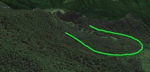
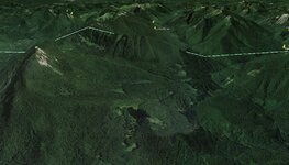
This is the basic Google Earth image, nothing too impressive. The original question haunting me, why is there a flat spot when everything else is mountains? But a couple days ago I noticed the ancient waterfall front and center in the image. "What the hell is that doing there"?, I asked myself.
Base.JPG

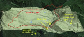
I was also working on looking for high benches, so I created an overlay for the area of interest. Now I noticed a "bench" running the entire perimeter of the flattened area at about the same elevation, with the exception of a massive missing section where the current stream bed is. The "bench" height coincided not only with the ancient waterfall I had observed, but also with the strange ancient river course through the woods along the road that accesses this area on the right. That old stream bed in the mountains has always intrigued me. Now I can see that it used to be the drainage for this ancient lake.
topo12 copy.jpg

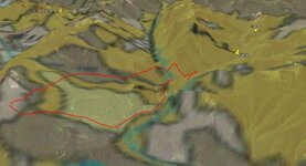
This also coincides with the geological map of the area to some extent.
geo11.JPG

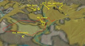
Now the part I don't know is: Does this help me at all with finding any super enriched gold deposits? I do not believe the gold was exposed until the violent uplift of the ridge which split the valley. I hypothesize that the force of this uplift created the hydraulic pressure that created first the waterfall and then blew out the entire canyon wall and drained the lake/sea. Without getting too far into it this event would coincide with the massive destructive event approximately 45 million years ago 'geologic time' (12000 yrs. bible time). So I'm not sure that the lake actually existed in the time that the gold has been exposed to weathering.
geo11 copy.jpg

My observations coincide with 1977 evaluation of this mining district as to the descriptions given of the ore bodies and the alteration state of the vein emplacement and heavily altered host rocks. Showing both hydrothermal emplacement and high temperature alteration of the original material.

I figured I'd post it up and see what folks had to say about it all.
Please feel free to share you thoughts on this. Wisdom is found in a multitude of counselors.
 

Last edited:
Upvote 0

goldenIrishman

Silver Member
Feb 28, 2013
3,465
6,152
Golden Valley Arid-Zona
Detector(s) used
Fisher / Gold Bug AND the MK-VII eyeballs
Primary Interest:
Other
Uplift of mountains over time is something that a lot of miners never think about. Most never even try to think in geological time, erosion, uplift and they should. The grounds we hunt haven't always been as they are now. Between glaciers coming down from the north and the Pacific Plate running smack dab into the North AND South American plates a lot has changed over the years. This subduction zone is the miners best friend! If it wasn't for it, there wouldn't be near the amount of gold out there to find in the western states. Learning about the paleo geology is important if you're going to be more than just a weekend warrior. How the mountains formed and the gold got deposited in them is cool to learn. The majority of the big deposits are found in the north/south running ridges that were pushed up by the pacific plates movement under the North American one.

I think you're on the right track and should be able to answer your question on your own in just a short time. Keep working on it.
 

winners58

Bronze Member
Apr 4, 2013
1,729
4,058
Oregon
Primary Interest:
All Treasure Hunting
looks like a lava dome that caved off to me. get out there and explore dig lot of holes
zoom out from here 46.400116 -121.817295

.
 

Last edited:

Clay Diggins

Silver Member
Nov 14, 2010
4,885
14,258
The Great Southwest
Primary Interest:
Prospecting
Why would you think that was an "ancient" waterfall?

Unless you can give logical answers based on the geological history of your area those are just ideas you have, not a discovery.

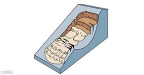
For instance what you believe is an "ancient" waterfall looks exactly like a rotational slide:

rotational-landslide.jpg

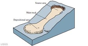
or possibly partially an earthflow, see the characteristic hourglass shape?

earthflow.jpg

You might find another reason the earth slumped there but none of those reasons are going to be "ancient". The "waterfall" you see is clearly a recent geological phenomenon that was not caused by surface water erosion. Study more on why the earth moves HERE. I think you will see my point.

Most if not all of the information you need to discover the geologic history of your area is freely available. That landslide probably has a name and a time frame already pinned down. There is no need to reinvent the wheel. With a little searching and study time (research) you will find that most of your questions are already answered.

I hope that helps. If you care to share where your area of interest is I'm sure I could point you to some information that would help your understanding.

Heavy Pans
 

OP
OP
Ragnor

Ragnor

Sr. Member
Dec 7, 2015
445
422
Primary Interest:
All Treasure Hunting
Thanks for your input Clay. I'll explain my theory and answer a few of your questions.

My hypothesis is based on my observations of the surrounding area. Observations made on the ground and through areal photography. Here is what I see that supports my waterfall.
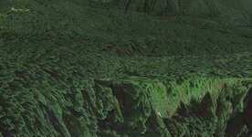
From this angle no debris pile is visible below the rock fall/ waterfall area
close.JPG

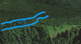
These two images show the area above the fall. The 50 foot tall cut bank to me looks to indicate an extensive scour zone. I have not been to the area yet. I plan to in the spring. I expect to find evidence to support that this area was scoured by a large volume of water. I do not 'know' that I am correct. This is just my initial observation.
cutbankmod copy.jpg cutbank.JPG


Now in support of your assertion that this is only recent subsidence I looked from a wider angle than before and did find that the recent fall material is still in place and may be a result of perhaps the 1700 quake. I maintain that both could be correct. That the existing wall collapse may have occurred much more recently. I maintain that a massive volume of water passed this way. All the mountains in this area hard enough to resist erosion show water wear on they're surface. Smooth and rounded, to great elevation. Unless the faces have collapsed.
subsidance.JPG

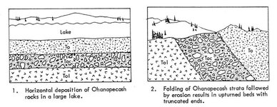
I also did some more searching due to your prompting and did find this
I havn't read the full report yet. But it does support the lake theory.
Ohana1.JPG


I learn all this stuff by ground observations, reading some books and scrounging around the internet. I know about Marshall T Hunting and some of his work, but I have no idea how to look up all this stuff. I don't even know where to look. I figure I am doing alright for figuring it out myself. I am always looking to learn more information and expand my understanding.
When I say I have made a discovery. I mean I have figured something out that was not shown to me. If someone else discovered it first that is all fine and well. and if they wrote it in a book I'd love to read it.

Imagine how disappointed I was to find that someone else had already figured out that mass times the area of the crystal lattice multiplied by it's frequency equaled the energy potential of the crystal. "Yes, that is E=Mc squared" my brother told me......
My point being "hey, at least I figured it out" (sort of).

Thanks again for making me think harder about it and look for new sources.

Why would you think that was an "ancient" waterfall?

Unless you can give logical answers based on the geological history of your area those are just ideas you have, not a discovery.

For instance what you believe is an "ancient" waterfall looks exactly like a rotational slide:


or possibly partially an earthflow, see the characteristic hourglass shape?


You might find another reason the earth slumped there but none of those reasons are going to be "ancient". The "waterfall" you see is clearly a recent geological phenomenon that was not caused by surface water erosion. Study more on why the earth moves HERE. I think you will see my point.

Most if not all of the information you need to discover the geologic history of your area is freely available. That landslide probably has a name and a time frame already pinned down. There is no need to reinvent the wheel. With a little searching and study time (research) you will find that most of your questions are already answered.

I hope that helps. If you care to share where your area of interest is I'm sure I could point you to some information that would help your understanding.

Heavy Pans
 

Last edited:

Hitndahed

Hero Member
Dec 4, 2014
866
874
Deep in the woods in South Central Pa.
Detector(s) used
Fisher CZ7 Pro
Primary Interest:
All Treasure Hunting
It COULD BE,,,very well could be.
It does not take much to alter and then confuse our pnut brains.
Fast regeneration of forests, earthquakes move waterways all the time.
They also create and destroy waterfalls.
I say head to the supposed bottom of the waterfall and get your self some spoons of material.

\Screw together 1" pipe sections and pound em in as far as humanly possible.
Trip it out of the hole and check your new "core".
IF it shows material that could allude to gold being there then I would go for it.
Gonna be a pile of hard work, no doubt about that man.
But THIS may be YOUR ticket ya know.
Good Luck and HP
 

spillercanyon

Sr. Member
Jan 4, 2012
269
466
California
Primary Interest:
Prospecting
It looks like the 50' wall is actually a fault escarpment, a fault would be running at the bottom of that 50' escarpment. Evidence of a an old lake should be fairly easy to find, a lot of very fine mud and silt from the lake bottom had to go somewhere if there was such a cataclysmic event. As far as the ancient stream bed and waterfall, look for rounded cobble, find it on bedrock and sample it. If the blowout is on the southern portion of the map, I would assume the water from the lake would flow through the blowout to the south, which would not cause any gold deposition in the northern portion of the map. My two bits.
 

Clay Diggins

Silver Member
Nov 14, 2010
4,885
14,258
The Great Southwest
Primary Interest:
Prospecting
Thanks for your input Clay. I'll explain my theory and answer a few of your questions.
All the mountains in this area hard enough to resist erosion show water wear on they're surface. Smooth and rounded, to great elevation.

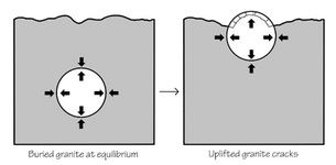
Let's start with the basics. Those smooth rounded mountains are composed of granites. Granite exfoliates in round forms due to the releasing of compression forces within the rock. All those smooth round rocks and mountains are due to the process of exfoliation. Water forces have little or nothing to do with the form granite erodes to or the rounded shape of the mountains.

Here's a diagram to help you understand:

exfoliation-diagram_sm.png

Read the article HERE.

HERE is a link to a video showing granite exfoliation in action in real time.

Get an understanding of the basics and then you will understand why what you are seeing is indeed a landslide. Waterfalls in granite and basalt mountains are the result of landslides or block faulting.

Lakes and waterfalls aren't a good place to look for gold. Landslides sometimes are because placer gold moves down steep slopes primarily by means of landslides, not by water erosion.

Your "waterfall" is higher at the lip than the surrounding area so obviously it wasn't created by water erosion. Your "cut bank" is clearly the scarp at the top of the uppermost slump block of the landslide. The curved rotational aspect of the landslide is seen in the form of the top slump block that you are calling a "cut bank". You can see the same curved effect in the earlier diagrams I posted.

I'm sharing this information to help you research the area. I'll, once again, offer the simple fact that there is already a good scientific explanation of the exact features you are seeing on Google Earth. Other people have already measured, sampled and drilled the area and the results are freely available for you to study.

If you don't care to look up the already available reports I encourage you to look up the meanings of the words I put in italics. Your research will go much easier if you get a grasp of those basic terrain forming processes. :thumbsup:

Heavy Pans
 

Alex Burke

Hero Member
Apr 3, 2013
869
700
NorCal
Detector(s) used
BH, GB2
Primary Interest:
Prospecting
I think you are heading in the right direction but it is important to understand the rock types and how the deposits form. Combining historical mining maps with modern seismic and mineral maps will show you that most deposits/mines are associated with high angle reverse thrust faults. These are faults that are above 53 degrees so only extreme pressures can reactivate these faults and release gold bearing solutions to surface.

There are other factors that play into if the gold has a chance to fall out of solution but basically lesser angle faults always give way first and the pressures needed to get the gold in solution to the surface occur more often on high angle reverse thrust faults. Here are a couple of links that talk about "Fault Valve Theory." This scientific model has only been around 30 years or so and has essentially been proven. It has has solved many questions that stumped the previous generations of geologists. This becomes obvious when reading old geo reports of gold mining areas. Hope these links help and good luck with your prospecting. Edit: after reading further into the thread you probably know way more than me about geology but maybe these links will be helpful to others:)


https://structuredatabase.wordpress.com/high-angle-reverse-faults-the-fault-valve-model-2/

http://m.geology.gsapubs.org/content/16/6/551.short

http://training.swpartnership.org/CCSclass/Decision_Module_files/Sibson_1992.pdf
 

Last edited:

motohed

Hero Member
Dec 27, 2015
670
499
RI
Detector(s) used
XP DEUS , AND OLDER GARRETT'S
Primary Interest:
All Treasure Hunting
I would still check the bottom of what you expect to be the waterfall , I realize many here are more qualified then I geologicly , but it does'nt hurt to go on gut instinct now and then . I mean other than time and a little money what do you have to lose . I would have to check it out , some times instinct is better than learning , Just do it , many have passed over areas because they knew to much about geology , That is at best Hypothises . I am know way taking away from their credit of learning , just saying , you may never dig any where if you get caught up in all of the geology . Gold is really where you find it , so it does'nt hurt to look .
 

Last edited:

et1955

Hero Member
Jan 10, 2015
913
1,783
Shoreline,wa
Detector(s) used
Equinox 800
Primary Interest:
Prospecting
A book you should read, Washington state geology for dummies, it explains why you found a dolphin bone fossil or why we find 3 ft. long fern fossils near Bluet pass. You may want to check out the gold mining history of the Swauk creek area, they are still finding nuggets that way pounds. Just a little incite, the majority of Wa. state is made up of tropical islands that threw Plate tectonics crash into the mainland which is near the Okanogan area. Fun stuff
 

OP
OP
Ragnor

Ragnor

Sr. Member
Dec 7, 2015
445
422
Primary Interest:
All Treasure Hunting
I would still check the bottom of what you expect to be the waterfall , I realize many here are more qualified then I geologicly , but it does'nt hurt to go on gut instinct now and then . I mean other than time and a little money what do you have to lose . I would have to check it out , some times instinct is better than learning , Just do it , many have passed over areas because they knew to much about geology , That is at best Hypothises . I am know way taking away from their credit of learning , just saying , you may never dig any where if you get caught up in all of the geology . Gold is really where you find it , so it does'nt hurt to look .

Well, I do not discredit anyone elses experience or understanding and I know that allot of time and effort has gone into understanding this area by those before me. However in a steep vast area with massive amounts of ground cover things do occasionally get missed. I have already located one such place that falls outside the known parameters of this particular area. I greatly respect the man who did the last geological map of this area, but the fact is he missed at least one very significant feature in his mapping of the area. I can assume he missed more. I don't think it hurts anything to draw outside the lines once in a while if it helps paint a prettier picture. So to speak.
I have long said anyone who thinks they know all there is to know is no longer capable of learning. I recon I'm still learning.
 

motohed

Hero Member
Dec 27, 2015
670
499
RI
Detector(s) used
XP DEUS , AND OLDER GARRETT'S
Primary Interest:
All Treasure Hunting
Well, I do not discredit anyone elses experience or understanding and I know that allot of time and effort has gone into understanding this area by those before me. However in a steep vast area with massive amounts of ground cover things do occasionally get missed. I have already located one such place that falls outside the known parameters of this particular area. I greatly respect the man who did the last geological map of this area, but the fact is he missed at least one very significant feature in his mapping of the area. I can assume he missed more. I don't think it hurts anything to draw outside the lines once in a while if it helps paint a prettier picture. So to speak.
I have long said anyone who thinks they know all there is to know is no longer capable of learning. I recon I'm still learning.

I think that everyone doing Geology , have slightly different styles in the way they inturpret what they see. I've done a few Geology classes , and by know means am I an expert . Novice is more like it , but what I'm getting at , is that in these classes the information was all interprated some what differently . Geology is a science that involves many millons of years , and what happened over all those years . That being said , how can we learn everything corectly in the short time , we are on this earth .
 

Goldwasher

Gold Member
May 26, 2009
6,077
13,225
Sailor Flat, Ca.
🥇 Banner finds
1
Detector(s) used
SDC2300, Gold Bug 2 Burlap, fish oil, .35 gallons of water per minute.
Primary Interest:
All Treasure Hunting
Interesting thing about geology is it happened the way it happened regardless of how you "think" it happened............
 

motohed

Hero Member
Dec 27, 2015
670
499
RI
Detector(s) used
XP DEUS , AND OLDER GARRETT'S
Primary Interest:
All Treasure Hunting
Interesting thing about geology is it happened the way it happened regardless of how you "think" it happened............

Yes it is , and I hope we never stop learning about geological events , and differing opinion .
 

Last edited:

Alex Burke

Hero Member
Apr 3, 2013
869
700
NorCal
Detector(s) used
BH, GB2
Primary Interest:
Prospecting
How did you get those 3D images in the OP? Is that google earth screenshots lately and I'm missing something lol or a diff program?
 

GrizzlyGremlin

Hero Member
Nov 17, 2012
594
761
Hey Rag, so I'm a bit confused, are you looking for placer gold or lode gold? Geology is would be important to finding lode gold, but "benched placers" have much less to do with geology, and greatly more directed towards Geomorphology. This is my area of interest and education. The way the land formed has an influence on deposition, but understanding how the earth moved after geological functions formed these features is of utmost importance.
I LOVE the mention of geologic time!
The biggest thing I try to keep in mind is that there were 2 major recent glaciations in north america. These events formed 99% of what we observe. Uplift, heave, folding, fracturing, and many other geologic processes happen very slow, and was not very dramatic because it happened over epochs.
Imagine now a MILE of ice above you, and the scouring, grinding, and plowing this caused. Now also imagine this mile of ice ablating, and the immense forces of this water.
What remains is a landscape that doesn't resemble the pre glaciated landscape whatsoever. The glaciers ground mountains down thousands of feet, and the water cut canyons thousands of feet deep. This gold game does not get simple with more knowledge! Haha quite the opposite! The more we all learn... the more questions!!
 

Top Member Reactions

Users who are viewing this thread

Top