This is for all the dedicated researchers out there. Tell me about the mineralization in this area.
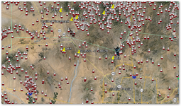
Your challenge, should you choose to play, is to describe to us what minerals worth mining are where in this map area. I'm hoping those who use "satellite" photos (actually aerial photos from a low flying plane) and other forms of "remote sensing" will put their two cents in, I'd like to hear your results and reasoning.
Here's your map link.
I know this area like the back of my hand so if you think you can use the MRDS or regular geology mapping I'll give you a heads up - they are wrong.
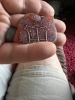
This is a well known and heavily mined area. There are several mineral patents for different mineral deposits in this rough cube just four miles on a side. You might be able to figure out what's going on here from those patents or any other method you like. Just please tell us what research methods you used.
This is not a trick or an invitation for some members to take threads off track. Just make your best guess and put it out there. This is not a contest. There are no winners or losers just folks willing to learn from others - myself included.
Heavy Pans
Your challenge, should you choose to play, is to describe to us what minerals worth mining are where in this map area. I'm hoping those who use "satellite" photos (actually aerial photos from a low flying plane) and other forms of "remote sensing" will put their two cents in, I'd like to hear your results and reasoning.
Here's your map link.
I know this area like the back of my hand so if you think you can use the MRDS or regular geology mapping I'll give you a heads up - they are wrong.
This is a well known and heavily mined area. There are several mineral patents for different mineral deposits in this rough cube just four miles on a side. You might be able to figure out what's going on here from those patents or any other method you like. Just please tell us what research methods you used.
This is not a trick or an invitation for some members to take threads off track. Just make your best guess and put it out there. This is not a contest. There are no winners or losers just folks willing to learn from others - myself included.
Heavy Pans
Amazon Forum Fav 👍


Upvote
0

 )Anyhow, I got side tracked and kept reading about all the cool stuff in that area surrounding your map link.. then you had the answer when I finally made it Back.


")