Mineral Withdrawal Question

Au-N-Rod

Jr. Member
Mar 5, 2015
46
44
Texas
Primary Interest:
Prospecting
On a facebook group I am a member of, a comment popped up I was curious about. A guy made the comment that on FS land, it was allowable to pan even if the area had been withdrawn from minerals. It can not be claimed, but he said it could be worked unless there were other restrictions in place.

I was curious if this was true, as I have an interesting place located which was withdrawn.

Rodney
 

Upvote 0

SpecJet

Jr. Member
May 8, 2013
83
105
So Cal
Primary Interest:
Prospecting
This is true, for the most part. Depending on the designation of the Withdrawn land, prospecting could still be legal.

Areas that have been designated as National Monuments, National Parks and a host of other designations block prospecting all together.

I would research the "interesting place" to find out why it was withdrawn before going to take samples.
 

OP
OP
A

Au-N-Rod

Jr. Member
Mar 5, 2015
46
44
Texas
Primary Interest:
Prospecting
Not a Park or Monument. The spot is inside a National Forest, in the last section before private land.
 

Clay Diggins

Silver Member
Nov 14, 2010
4,885
14,258
The Great Southwest
Primary Interest:
Prospecting
Usually mineral closures do not restrict prospecting or exploration. Each withdrawal needs to be studied for the exact wordings of the restrictions but in almost all cases only "location and entry" (claims and patents) are listed as the withdrawn rights.

Study the Master Title Plat and supplements to find out what the PLO# is and look that up in the Federal Register to see the wording and length of the withdrawal. Often these withdrawals expire without notice. :thumbsup:

Heavy Pans
 

chlsbrns

Bronze Member
Mar 30, 2013
1,636
656
Detector(s) used
Excalibur II
Primary Interest:
Other
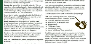
From the FS website...
 

Attachments

  • 2016-02-28_21.31.02.jpg
    2016-02-28_21.31.02.jpg
    166.3 KB · Views: 154

KevinInColorado

Gold Member
Jan 9, 2012
7,037
11,370
Summit County, Colorado
Detector(s) used
Grizzly Goldtrap Explorer & Motherlode, Gold Cube with trommel or Banker on top, Angus Mackirk Expedition, Gold-n-Sand Xtream Hand pump
Primary Interest:
Prospecting
Despite what the FS says on their website, Wilderness Areas do allow manual prospecting as per the Wilderness Act.
 

goldenIrishman

Silver Member
Feb 28, 2013
3,465
6,152
Golden Valley Arid-Zona
Detector(s) used
Fisher / Gold Bug AND the MK-VII eyeballs
Primary Interest:
Other
As has been stated before.... You have to go and read and understand the withdrawal notice. In some cases manual prospecting is still allowed but claims are not. The withdrawal order will have the details in its wording. You can go to the LandMatters site and download both the master plat as well as a tutorial on how to read them at no cost. Look in the Maps/Land Status Maps/ State land status for the correct area. Turn on the information button and click on the section that the area is located in. When the information window opens up you will see a link in it to download the Master Plat.
 

OP
OP
A

Au-N-Rod

Jr. Member
Mar 5, 2015
46
44
Texas
Primary Interest:
Prospecting
Despite what the FS says on their website, Wilderness Areas do allow manual prospecting as per the Wilderness Act.

This area I am looking at was withdrawn to Wilderness.

This is in New Mexico. I do not see a Master Plat link with the info button.
 

chlsbrns

Bronze Member
Mar 30, 2013
1,636
656
Detector(s) used
Excalibur II
Primary Interest:
Other
Minerals
Sand, Gravel, and Decorative Rock Permits may be obtained from various pre-approved areas on the Forest with a personal use permit. These permits are free, however, material may only be removed from specific areas.
Permits are not generally required for non-commercial personal use (recreational) metal detecting, rock collecting (hounding), gold panning (dry wash or manual pan, not using any type of powered equipment, such as a sluice or dredge). Digging in the forest for any purpose is not permitted.

USDA Forest Service - Recreation, Heritage and Wilderness
 

KevinInColorado

Gold Member
Jan 9, 2012
7,037
11,370
Summit County, Colorado
Detector(s) used
Grizzly Goldtrap Explorer & Motherlode, Gold Cube with trommel or Banker on top, Angus Mackirk Expedition, Gold-n-Sand Xtream Hand pump
Primary Interest:
Prospecting
Here's the text from the actual Wilderness Act law:
(2) Nothing in this Act shall prevent within national forest wilderness areas any activity, including prospecting, for the purpose of gathering information about mineral or other resources, if such activity is carried on in a manner compatible with the preservation of the wilderness environment. Furthermore, in accordance with such program as the Secretary of the Interior shall develop and conduct in consultation with the Secretary of Agriculture, such areas shall be surveyed on a planned, recurring basis consistent with the concept of wilderness preservation by the United States Geological Survey and the United States Bureau of Mines to determine the mineral values, if any, that may be present; and the results of such surveys shall be made available to the public and submitted to the President and Congress. Mineral leases, claims, etc. (3) Not withstanding any other provisions of this Act, until midnight December 31, 1983, the United States mining laws and all laws pertaining to mineral leasing shall, to the extent as applicable prior to September 3, 1964, extend to those national forest lands designated by this Act as "wilderness areas"; subject, however, to such reasonable regulations governing ingress and egress as may be prescribed by the Secretary of Agriculture consistent with the use of the land for mineral location and development and exploration, drilling, and production, and use of land for transmission lines, waterlines, telephone lines, or facilities necessary in exploring, drilling, producing, mining, and processing operations, including where essential the use of mechanized ground or air equipment and restoration as near as practicable of the surface of the land disturbed in performing prospecting, location, and , in oil and gas leasing, discovery work, exploration, drilling, and production, as soon as they have served their purpose. Mining locations lying within the boundaries of said wilderness areas shall be held and used solely for mining or processing operations and uses reasonably incident thereto; and hereafter, subject to valid existing rights, all patents issued under the mining laws of the United States affecting national forest lands designated by this Act as wilderness areas shall convey title to the mineral deposits within the claim, together with the right to cut and use so much of the mature timber therefrom as may be needed in the extraction, removal, and beneficiation of the mineral deposits, if needed timber is not otherwise reasonably available, and if the timber is cut under sound principles of forest management as defined by the national forest rules and regulations, but each such patent shall reserve to the United States all title in or to the surface of the lands and products thereof, and no use of the surface of the claim or the resources therefrom not reasonably required for carrying on mining or prospecting shall be allowed except as otherwise expressly provided in this Act: Provided, That, unless hereafter specifically authorized, no patent within wilderness areas designated by this Act shall issue after December 31, 1983, except for the valid claims existing on or before December 31, 1983. Mining claims located after September 3, 1964, within the boundaries of wilderness areas designated by this Act shall create no rights in excess of those rights which may be patented under the provisions of this subsection. Mineral leases, permits, and licenses covering lands within national forest wilderness areas designated by this Act shall contain such reasonable stipulations as may be prescribed by the Secretary of Agriculture for the protection of the wilderness character of the land consistent with the use of the land for the purposes for which they are leased, permitted, or licensed. Subject to valid rights then existing, effective January 1, 1984, the minerals in lands designated by this Act as wilderness areas are withdrawn from all forms of appropriation under the mining laws and from disposition under all laws pertaining to mineral leasing and all amendments thereto.
 

chlsbrns

Bronze Member
Mar 30, 2013
1,636
656
Detector(s) used
Excalibur II
Primary Interest:
Other
You guys need to learn how to comprehend what you read!
 

Clay Diggins

Silver Member
Nov 14, 2010
4,885
14,258
The Great Southwest
Primary Interest:
Prospecting
This area I am looking at was withdrawn to Wilderness.

This is in New Mexico. I do not see a Master Plat link with the info button.

Kevin gave you the right answer for prospecting in wilderness Rod.

You would need to go to the Land Matters Land Status Maps to get the Master Title Plat map layer. Once you turn on that map layer your information queries will have Master Title Plat (and supplements if there are any) download link(s) in the information results window. :thumbsup:

Heavy Pans
 

Last edited:

goldenIrishman

Silver Member
Feb 28, 2013
3,465
6,152
Golden Valley Arid-Zona
Detector(s) used
Fisher / Gold Bug AND the MK-VII eyeballs
Primary Interest:
Other
I'm going to use the Pecos Wilderness for this step by step. North east of Santa Fe. By the PLSS I'm looking in T&R 18N-11E. For this exercise we will use section 33.

Once you've zoomed into the area in question and you're sure of your location, make sure that you have the Master Title Plats and Supplements layer turned on and have refreshed the screen using the map refresh button from the tool bar. DO NOT use the browser refresh as that will put you back at square one!!!! Once the map has refreshed you should see a grid layer over it in green. Now turn on the information tool ("I"Button) and click on the area. A window should open up that lists the layers that are currently turned on. In that window, look for the row that says "Layer: Master Title Plats and Supplements" On the right hand side of that row you should find the download link for the Master Plat for that township and Range. Click on the link and follow the instructions.

Master Plats USUALLY cover entire townships and any supplemental info may be for specific sections within that area. Don't forget to download Clays handy guide to reading master plats.
 

chlsbrns

Bronze Member
Mar 30, 2013
1,636
656
Detector(s) used
Excalibur II
Primary Interest:
Other
You can take a course and learn how to navigate a painfully slow, confusing website that will not answer your question or you can do yourself a favor and go to: USDA Forest Service - Recreation, Heritage and Wilderness

Scroll down to New Mexico, find the NF that you want to pan in and call the Ranger to find out if you can or can not do what you want to do and if any permits are required.

Each NF has different laws. For example the Santa Fe page says:

While panning is generally a recreational activity, it is regulated under the mining regulations (36 CFR 228, Subpart A). Mining activities, including recreational panning, are prohibited within Santa Fe National Forest campgrounds, the Jemez NRA, Wild and Scenic Rivers, and Wilderness.
 

Last edited:

Clay Diggins

Silver Member
Nov 14, 2010
4,885
14,258
The Great Southwest
Primary Interest:
Prospecting
I'm going to use the Pecos Wilderness for this step by step. North east of Santa Fe. By the PLSS I'm looking in T&R 18N-11E. For this exercise we will use section 33.

Once you've zoomed into the area in question and you're sure of your location, make sure that you have the Master Title Plats and Supplements layer turned on and have refreshed the screen using the map refresh button from the tool bar. DO NOT use the browser refresh as that will put you back at square one!!!! Once the map has refreshed you should see a grid layer over it in green. Now turn on the information tool ("I"Button) and click on the area. A window should open up that lists the layers that are currently turned on. In that window, look for the row that says "Layer: Master Title Plats and Supplements" On the right hand side of that row you should find the download link for the Master Plat for that township and Range. Click on the link and follow the instructions.

Master Plats USUALLY cover entire townships and any supplemental info may be for specific sections within that area. Don't forget to download Clays handy guide to reading master plats.

Map Search Hint:

You can save a step when using the information tool by simply clicking the layer boxes of the layers you want to query. The information result window will include a search of any layer that is clicked on without the need to reload the map first. :thumbsup:

Once you are zoomed into your area of interest you can get information from different layers and different areas by just leaving the results window open and selecting different map layers from the list and clicking wherever you want information. The information in the Result window will change to show your selected layers and the area of your click without ever waiting for a map to redraw.

The Result window can be moved around by click dragging on the window title bar. You can change the window size by click dragging the bottom right corner. Once you come up with the best window position and size for your needs the window will remember that position whenever it opens for as long as you stay on that map.

Heavy Pans
 

Last edited:
OP
OP
A

Au-N-Rod

Jr. Member
Mar 5, 2015
46
44
Texas
Primary Interest:
Prospecting
Thanks for the help. This old fart has troubles sometimes.

I got as far as goldenirishman led me. But, I use a firefox browser and it wanted to know what I wanted to use to open the download. And none of mine seem to work. Any suggestions there? lol
 

Top Member Reactions

Users who are viewing this thread

Latest Discussions

Top