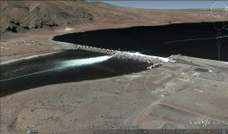
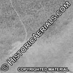
Are theses dredge tailings or something?

OwenT

Hero Member
Feb 11, 2015
572
858
Moses Lake WA & Provo UT
Primary Interest:
Prospecting
First thing I thought when I saw this on the Columbia River was dredge tailing, but it's actually more of a snaking pattern than the stacked arcs a dredge would make. This area on the river did produce gold. Untitled.png
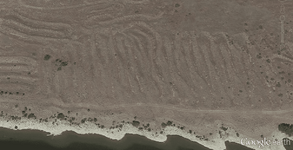


Note to anyone beginning to read this thread: It was determined that the picture shows the remnants of some sort of gold mining operation. The thread then turns a little off track and there is a debate for several pages. Finally we discuss land status and I try to find out who owns this property.
 

Last edited:
Upvote 0

Goldwasher

Gold Member
May 26, 2009
6,077
13,225
Sailor Flat, Ca.
🥇 Banner finds
1
Detector(s) used
SDC2300, Gold Bug 2 Burlap, fish oil, .35 gallons of water per minute.
Primary Interest:
All Treasure Hunting
The mounds are the soil that was excavated from when the dam was built. 1956-1959
You can see the tire tracks going from the dam to the piles in historic aerial photos.

History of Grant County PUD
very obvious that those mounds are not the same as the ones owen showed us. The are is way too down stream of the dam to have been of use on the project. The same sort of material was available much closer to the construction site.

Owens location is some sort of washed gravels that were dug and left in place. Nothing was removed in bulk and they were not left there after being removed from a differen area.
 

Last edited:
OP
OP
OwenT

OwenT

Hero Member
Feb 11, 2015
572
858
Moses Lake WA & Provo UT
Primary Interest:
Prospecting
Yea this site is over 4 miles from the dam and the piles aren't that big. I saw a date for the Chinaman's Bar Placer which may or may not be this spot and it said '39-'41. I doubt bedrock is within a hundred feet of the surface.
 

chlsbrns

Bronze Member
Mar 30, 2013
1,636
656
Detector(s) used
Excalibur II
Primary Interest:
Other
very obvious that thos mounds are not the same as the ones owen showed us. The are is way too down stream of the dam to have been of use on the project. The same sort of material was available much closer to the construction site.

Owens location is some sort of washed gravels that were dug and left in place. Nothing was removed in bulk and they were not left there after being removed from a differen area.

The piles are three miles from the dam. If you looked at historic aerials as I mentioned you can see that the piles came from the dam. Gezz I wonder what would happen to piles of rocks and soil that have sat for over fifty years? Think maybe the soils could have washed away and left gravels? AMAZING!

Chinamans Bar Placer: http://westernmininghistory.com/mine_detail/10055911

http://mrdata.usgs.gov/mrds/show-mrds.php?dep_id=10055911
 

Last edited:

Goldwasher

Gold Member
May 26, 2009
6,077
13,225
Sailor Flat, Ca.
🥇 Banner finds
1
Detector(s) used
SDC2300, Gold Bug 2 Burlap, fish oil, .35 gallons of water per minute.
Primary Interest:
All Treasure Hunting
The piles are three miles from the dam. If you looked at historic aerials as I mentioned you can see that the piles came from the dam. Gezz I wonder what would happen to piles of rocks and soil that have sat for over fifty years? Think maybe the soils could have washed away and left gravels? AMAZING!

Chinamans Bar Placer: Chinaman Bar Placer

Chinaman Bar Placer (MRDS #10055911) AU
I liked your comment because its plausable. However those piles in your picture are not the ones owen is refering to the terrain is different and there is no river in the picture. The piles in Owens picture are right next to the river on a flood plain. Your picture is not a flood plain. It is an arid environment the pile in your picture are laid out in rows Owens piles are more irregular and smaller. even six decades of wet seasons would not make your piles look like Owens.

Do you have a link to a picture of that spot that shows those piles NOT existing before the dam? The earliest I can find is 1964.

I am not trying to start a battle so please don't start getting smart about stuff please just answer and provide relevant info if you have it
 

chlsbrns

Bronze Member
Mar 30, 2013
1,636
656
Detector(s) used
Excalibur II
Primary Interest:
Other
I liked your comment because its plausable. However those piles in your picture are not the ones owen is refering to the terrain is different and there is no river in the picture. The piles in Owens picture are right next to the river on a flood plain. Your picture is not a flood plain. It is an arid environment the pile in your picture are laid out in rows Owens piles are more irregular and smaller. even six decades of wet seasons would not make your piles look like Owens.

Do you have a link to a picture of that spot that shows those piles NOT existing before the dam? The earliest I can find is 1964.

I am not trying to start a battle so please don't start getting smart about stuff please just answer and provide relevant info if you have it

Did you click the link that is with the picture? It is where I got the pic. They are historic pics of when the dam was built.

History of Grant County PUD

The terrain is different? They are pics from when the dam was built! No you can't see the river in the pic but you can see a bridge. Waterways are diverted when dams are built. The Columbia was a slow moving stream before dams were built.

Not that any of this matters! I would be tickled to death to find the soils excavated from when they built the dam. Easy pickings!
 

Goldwasher

Gold Member
May 26, 2009
6,077
13,225
Sailor Flat, Ca.
🥇 Banner finds
1
Detector(s) used
SDC2300, Gold Bug 2 Burlap, fish oil, .35 gallons of water per minute.
Primary Interest:
All Treasure Hunting
That bridge is not over the Columbia a river that is by no stretch a slow moving stream your own link shows ample evidence of how much water flows through the area.There are no hills like the ones in the background in your picture close to where the cited location is. It's not hard to see that on the Google Earth view. It is flat all around the area. There are hills like that on the other side though.

I know the piles in your link are from construction of the dam. They surely don't seem to be the location we are trying to figure out.
 

Last edited:

Goldwasher

Gold Member
May 26, 2009
6,077
13,225
Sailor Flat, Ca.
🥇 Banner finds
1
Detector(s) used
SDC2300, Gold Bug 2 Burlap, fish oil, .35 gallons of water per minute.
Primary Interest:
All Treasure Hunting
So no info on pre dam era ariel photos
 

chlsbrns

Bronze Member
Mar 30, 2013
1,636
656
Detector(s) used
Excalibur II
Primary Interest:
Other
That bridge is not over the Columbia a river that is by no stretch a slow moving stream your own link shows ample evidence of how much water flows through the area.There are no hills like the ones in the background in your picture close to where the cited location is. It's not hard to see that on the Google Earth view. It is flat all around the area. There are hills like that on the other side though.

I know the piles in your link are from construction of the dam. They surely don't seem to be the location we are trying to figure out.

Im not going to keep wasting my time! Yes there are hills on the other side! You can see them in the pic! ???

Believe whatever you want to believe! Btw, did you watch the videos of the dam being built at the link that I posted? They have some really cool trucks moving dirt!

Whats that saying about leading horses to water?
 

Aufisher

Bronze Member
May 12, 2013
1,948
4,830
The Golden State
Detector(s) used
Whites Goldmaster V/SAT. VibraProbe. Bazooka 48" Prospector Sluice. Shorts. Chickens + Goats + Goldhounds. 35' Chris Craft Caribbean motorsailer. FISH OIL + BURLAP
Primary Interest:
Prospecting
Where is that dam picture!
 

Goldwasher

Gold Member
May 26, 2009
6,077
13,225
Sailor Flat, Ca.
🥇 Banner finds
1
Detector(s) used
SDC2300, Gold Bug 2 Burlap, fish oil, .35 gallons of water per minute.
Primary Interest:
All Treasure Hunting
No you belive what you want. They are clearly not the same.. I watched the slide show it shows them working on the dam three miles away from Owens piles and it shows other piles in another spot. And yes trucks that move water are cool.
 

chlsbrns

Bronze Member
Mar 30, 2013
1,636
656
Detector(s) used
Excalibur II
Primary Interest:
Other
No you belive what you want. They are clearly not the same.. I watched the slide show it shows them working on the dam three miles away from Owens piles and it shows other piles in another spot. And yes trucks that move water are cool.

You didn't see the pic in my last post? It makes it perfectly clear that the piles are from when the dam was constructed. So much for... They are to far from the dam!

I asked if you watched the VIDEOS not the slideshow.

The trucks were not moving water!
 

Last edited:

Goldwasher

Gold Member
May 26, 2009
6,077
13,225
Sailor Flat, Ca.
🥇 Banner finds
1
Detector(s) used
SDC2300, Gold Bug 2 Burlap, fish oil, .35 gallons of water per minute.
Primary Interest:
All Treasure Hunting
Such a pretty picture!

CONTENTdm Collection : Item Viewer

Look at the pretty water and mountains in the background and them long piles.


the bluffs in this picture are across from the dam site. The location of the aggregate plant as during construction. They are not gonna haul material three plus miles to source it or get rid of it . Makes no sense. The bluffs across from the other sight are different. You can see the difference in the formations clearly. Six decades in geologic time is nothing. Those bluffs look the same as they did in 1958 . Thank you for the picture that verifies your not right
 

Goldwasher

Gold Member
May 26, 2009
6,077
13,225
Sailor Flat, Ca.
🥇 Banner finds
1
Detector(s) used
SDC2300, Gold Bug 2 Burlap, fish oil, .35 gallons of water per minute.
Primary Interest:
All Treasure Hunting
The mounds are the soil that was excavated from when the dam was built. 1956-1959
You can see the tire tracks going from the dam to the piles in historic aerial photos.

History of Grant County PUD
looks like the pic as taken somehere close to here at the dam sight. The picture seems to have been taken from the north bank area the opposite of the mounds in that are of interest. Your mounds are being used to build the dam. priest rapids.jpg

This angle is from above her the aggregate plant in your other pic ould be generally locate. The mound pic you linked as taken on the other side of the river same direction. if you panned left from this angle the bluffs in your aggregate plant pic could be seen.
 

Last edited:

Goldwasher

Gold Member
May 26, 2009
6,077
13,225
Sailor Flat, Ca.
🥇 Banner finds
1
Detector(s) used
SDC2300, Gold Bug 2 Burlap, fish oil, .35 gallons of water per minute.
Primary Interest:
All Treasure Hunting
cross river vie from Chinamens bar supposed tailings area.....pretty obvious its not the same as the pic submitted as the tailings. View attachment 1300570
 

chlsbrns

Bronze Member
Mar 30, 2013
1,636
656
Detector(s) used
Excalibur II
Primary Interest:
Other
I should have saved the aerial showing tire marks going back and forth from tne dam to the piles. On second thought you probably still wouldn't get it!
 

Goldwasher

Gold Member
May 26, 2009
6,077
13,225
Sailor Flat, Ca.
🥇 Banner finds
1
Detector(s) used
SDC2300, Gold Bug 2 Burlap, fish oil, .35 gallons of water per minute.
Primary Interest:
All Treasure Hunting
I should have saved the aerial showing tire marks going back and forth from tne dam to the piles. On second thought you probably still wouldn't get it!
sorry but google earth proves it......you should have saved it......you could still find pics of the piles not existing prior to the dam. tire tracks mean nothing.
 

chlsbrns

Bronze Member
Mar 30, 2013
1,636
656
Detector(s) used
Excalibur II
Primary Interest:
Other
Ok you keep believing that while you have no other feasible explanation.
 

Goldwasher

Gold Member
May 26, 2009
6,077
13,225
Sailor Flat, Ca.
🥇 Banner finds
1
Detector(s) used
SDC2300, Gold Bug 2 Burlap, fish oil, .35 gallons of water per minute.
Primary Interest:
All Treasure Hunting
The oldest pic I can find 1964. you can tell the piles are more than six years old. tailings 1964.jpg
 

Top Member Reactions

Users who are viewing this thread

Top