Finding the boundaries of a claim.

johngfoster

Jr. Member
Feb 7, 2016
54
66
NW Montana
Detector(s) used
30" Prospector BGT,
Garret pans (10", 14", SuperSluice),
Home-built Gold Hog-ish Highbanker a la Raptor
Primary Interest:
All Treasure Hunting
In this day and age, why does it have to be so freakin hard to find the boundaries of active mining claims? At least in Montana? With the advent of GoogleMaps, and the ability to use them as base maps, one would think it a simple task to superimpose the boundaries of current active claims with links to the owner details attached. But no. We still have the archaic LR2000 land mapping system that doesn't really tell you anything.

I was able to find a link to mylandmatters.org, which will use a satellite base map, but even that only tells you have many claims are in a particular area, and doesn't outline them for you on the map. It will give a link to the claim info though. Not sure how current it is though. If a hunting app like "onX HUNT" can outline property boundaries on a base map, I would think it quite a simple task to do the same thing with mining claims. Anyone have any help with this problem they can share with a frustrated noob?
 

Last edited:
Upvote 0

Reed Lukens

Silver Member
Jan 1, 2013
2,653
5,418
Congres, AZ/ former California Outlawed Gold Miner
Detector(s) used
Tesoro Vaquero, Whites MXT, Vsat, GMT, 5900Di Pro, Minelab GPX 5000, GPXtreme, 2200SD, Excalibur 1000!
Primary Interest:
All Treasure Hunting
If you want to see actual claim boundaries then the best thing that you can do is go to BLM and pull the file for each one. The claim owners submit their boundaries by hand, it's not put into a computer. Many folders will have maps and you can make copies of everything that you want from the folder.
 

Clay Diggins

Silver Member
Nov 14, 2010
4,883
14,245
The Great Southwest
Primary Interest:
Prospecting
The Land Matters Claims Maps are updated twice a month. Each claims information window shows you how recently the claim information was updated. The current update was on September 15th and the next will be on Oct 1st. They are the most current mining claim maps available to the public.

The LR2000 is not a mapping system it's a database of case files. There are no maps on the LR2000.

Mapping land status is a lot easier than mapping current claims. On Land Matters Maps you have a very accurate "Land Manager" layer that shows what areas are public lands and what agency manages them as well as whats private. That's a bunch of data on our server but it's nowhere near as complex, difficult and constantly changing as mining claim tracking. In the time since your hunting map was updated there were several hundred thousand claim changes.

In my business I do map claims to their recorded boundaries and I do put those on maps. Most of this work is done for private mining clients but I do produce limited areas with claims mapped in a software mapping program for the public.

Claims information can never be "current". The locators of mining claims have 90 days to make a public record of their claim. That record is made at the County Recorder's office and is usually available within two weeks of the record being made. You could, as I do, order copies of location notices from the County Recorder and plot them on your own map. It's how it has been done for more than 100 years. It's a long and sometimes difficult process but short of doing it yourself you are mostly going to be guessing as much as the average greenhorn. Guessing can get you in real trouble so it's better to learn the skill just as prospectors always have.

Reed suggested getting copies from the BLM. That can be a big help to get you started but in the end you will have to visit the County Recorder to get the actual record before you put "boots on the ground" and go looking for new location monuments. Not all of those BLM claims were ever properly recorded and the BLM often drags their feet in updating those claims case files - in some the information is as much as several years out of date.

If you study the information on the Land Matters maps you can usually figure out if a specific area has land open to location. The quarter section (1/4 mile) and sometimes the quarter quarter (1/8 mile - 1320 ft) are included in the LR2000 claim case information. If there are only 60 acres of active claims and they are all in the SW quarter section it might be worth your while to concentrate your efforts on the NW NE and SE of that Section.

There is no guarantee that the BLM information is correct or even particularly current so ultimately you will need to visit the County Recorder for your information. Obviously narrowing down your area of interest will be a big help in cutting down the work you need to do.

It is possible for a government to make this information available. The State of Alaska does it pretty well, British Colombia has a great claims mapping program and Australia has a pretty effective mapping system.

In the United States, due to the fact that claims are made by individual effort pursuant to an open discovery right, I seriously doubt you will ever see an accurate current mining claims map. The closest the U.S. ever came was the now worthless geocommunicator map. Land Matters was, in part, created to fill the gap left by the failure of that government botched system. If I could offer something better I would but with more than 8 million acres of mining claims in the western U.S. you are probably already experiencing the best it will ever be until you do your own research and maps.

Heavy Pans
 

Last edited:
OP
OP
J

johngfoster

Jr. Member
Feb 7, 2016
54
66
NW Montana
Detector(s) used
30" Prospector BGT,
Garret pans (10", 14", SuperSluice),
Home-built Gold Hog-ish Highbanker a la Raptor
Primary Interest:
All Treasure Hunting
Thanks, Clay. That was helpful. I guess I'll have to take a trip to the County Recorder and see what they have in the way of mapped out individual claims in the area I'm looking at. I do appreciate all you've done in getting the mylandmatters.org site up. I'll PM you about a particular apparent discrepancy I've had with it, and not bog this thread down with more specific info than is necessary.
 

goldenIrishman

Silver Member
Feb 28, 2013
3,465
6,152
Golden Valley Arid-Zona
Detector(s) used
Fisher / Gold Bug AND the MK-VII eyeballs
Primary Interest:
Other
Hey John,

Clay is 100% correct in that you're going to need to go to the county recorders office to check out the area you're interested in. The BLMs LR2000 system only lists a claims location down to the quarter section and you need to be more accurate than that to be sure you've got yourself covered against mineral trespass charges.

I've spent a lot of time at my county recorders office going through the records on their computer system and if the system your county uses is anything like ours, it's not hard to get the hang of it pretty quickly. The real trick I've learned is to have your notes with you and go through them in a systematic manner. Everything on our system is listed by township/range/section which makes finding the info you need very easy. Our clerks are great to work with and really helpful. They showed me how to get to the actual claim recording so I could get the exact boundaries of any claim in our county. If you're serious about doing your due diligence and doing it correctly, getting to know the system your county recorder uses is a must. Some counties offer a subscription service so you can access the records from home. Our is a little pricey @ $50 a month, but if you plan on getting printouts it can save you money in the long run. Most recorders offices will charge you about a buck a page for printouts and if you are going to be printing out a lot of pages......

The MyLandMatters site is the best resource available on-line today. Learn to use it well and it will help you a lot. Now if Clay could get it tied into all the county records as well, all he would need to do is come up with a function to dig the gold for us. ;)

I see your location is N.W. Montana. You anywhere near Troy?
 

IMAUDIGGER

Silver Member
Mar 16, 2016
3,400
5,194
Primary Interest:
All Treasure Hunting
In this day and age, why does it have to be so freakin hard to find the boundaries of active mining claims? At least in Montana? With the advent of GoogleMaps, and the ability to use them as base maps, one would think it a simple task to superimpose the boundaries of current active claims with links to the owner details attached. But no. We still have the archaic LR2000 land mapping system that doesn't really tell you anything.

I was able to find a link to mylandmatters.org, which will use a satellite base map, but even that only tells you have many claims are in a particular area, and doesn't outline them for you on the map. It will give a link to the claim info though. Not sure how current it is though. If a hunting app like "onX HUNT" can outline property boundaries on a base map, I would think it quite a simple task to do the same thing with mining claims. Anyone have any help with this problem they can share with a frustrated noob?

I highly doubt 99% of people filing/owning mining claims really have a handle on where their legal description actually falls on the ground.
This includes most people that prepare mining claim descriptions for a fee.

Unless it is a extremely valuable claim, it usually comes down to possession. People make a guess based on the best available information, then defend it like its right.
This seems to work, but would not hold up in a court of law.
 

T

Tuolumne

Guest
I highly doubt 99% of people filing/owning mining claims really have a handle on where their legal description actually falls on the ground.
This includes most people that prepare mining claim descriptions for a fee.

Unless it is a extremely valuable claim, it usually comes down to possession. People make a guess based on the best available information, then defend it like its right.
This seems to work, but would not hold up in a court of law.


Your right, most people don't know how to read a GPS let alone do the diligence to see where their neighbors corners are.

I have a geography minor from Humboldt state, make my own maps using Arcgis
I print maps on my laminated claim post so my stupid neigbors and gold clubs don't stumble onto my Unworked tertiary benches!
In fact it didn't help, I still got high graded by local gold club president and friends! Stay out of my defunct mining district or else lol!
So no matter how many times you will hear on this site " check out the area to see if it's claimed up" no one really pulls the county records to check and double check in the field. But doing so you realize that many claims are just on paper and corners have not been marked, or monument not to be found......

If anyone in tuolumne county wants help making a gis layer for mining districts and valid claims I'm down to help, it would be a great paper to present at the California geography yearly conference......

When I was a kid we would mushroom hunt near Denny, Agnes, marbles.... The coolest claim owners had maps attached to post in water tight bags so even a dimwit gold club president or hiker would know his/her exact orientation.

I've got a game cam on mine so if u see my map, smile for me! Lol
 

Last edited:

Reed Lukens

Silver Member
Jan 1, 2013
2,653
5,418
Congres, AZ/ former California Outlawed Gold Miner
Detector(s) used
Tesoro Vaquero, Whites MXT, Vsat, GMT, 5900Di Pro, Minelab GPX 5000, GPXtreme, 2200SD, Excalibur 1000!
Primary Interest:
All Treasure Hunting
Your right, most people don't know how to read a GPS let alone do the diligence to see where their neighbors corners are.

I have a geography minor from Humboldt state, make my own maps using Arcgis
I print maps on my laminated claim post so my stupid neigbors and gold clubs don't stumble onto my Unworked tertiary benches!
In fact it didn't help, I still got high graded by local gold club president and friends! Stay out of my defunct mining district or else lol!
So no matter how many times you will hear on this site " check out the area to see if it's claimed up" no one really pulls the county records to check and double check in the field. But doing so you realize that many claims are just on paper and corners have not been marked, or monument not to be found......

If anyone in tuolumne county wants help making a gis layer for mining districts and valid claims I'm down to help, it would be a great paper to present at the California geography yearly conference......

When I was a kid we would mushroom hunt near Denny, Agnes, marbles.... The coolest claim owners had maps attached to post in water tight bags so even a dimwit gold club president or hiker would know his/her exact orientation.

I've got a game cam on mine so if u see my map, smile for me! Lol

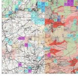
hehe... You mean something like this only current?

IdeaMXDll.jpg
 

Clay Diggins

Silver Member
Nov 14, 2010
4,883
14,245
The Great Southwest
Primary Interest:
Prospecting
I highly doubt 99% of people filing/owning mining claims really have a handle on where their legal description actually falls on the ground.
This includes most people that prepare mining claim descriptions for a fee.

Unless it is a extremely valuable claim, it usually comes down to possession. People make a guess based on the best available information, then defend it like its right.
This seems to work, but would not hold up in a court of law.

You may be right about that but it really doesn't matter if the legal description is a little off from the stakes. The courts have been very lenient with miners paperwork descriptions. If it ever comes down to court the stakes on the ground take precedence over any form of paper location notice every time. Locators are right to rely on the stakes and monuments they find no matter what the paperwork says. It's the law.

Claims are founded on the law of possession. The first Mining Act of 1865 established that as the basic principle of mining rights. Here is the entire text of the first Mining Act - still in effect today.
1865 Mining Act said:
That no possessory action between individuals in any of the courts of the United States for the recovery of any mining title, or for damages to any such title, shall be affected by the fact that the paramount title to the land on which such mines are, is in the United States, but each case shall be adjudged by the law of possession.

It's included in the other mining Acts just so there is no doubt about the legal basis for the act of claiming and holding a mining claim. Eight times in the 1872 Mining Act alone possession is declared the basis of ownership of a claim.
1872 Mining Act said:
Locators... shall have the exclusive right of possession

Same law today as in 1865 and it's the law in every court in the land so stakes on the ground and possession not only hold up in court they are the foundation the court relies on when there is a question as to physical location or ownership.

Mining is only a paper game in the stock market and the minds of internet posters. In real life mining and mining claims are all about the facts on the ground. Legally speaking. :thumbsup:

Heavy Pans
 

T

Tuolumne

Guest
Clay and Reed are at one with thier inner geographer... Exactly, nerdy layers....

For $8,000 you could get your parcel surveyed and that would be precise and more layers of documentation if land disputes arise.....that's at least how much it would cost in my area.
 

Last edited:

IMAUDIGGER

Silver Member
Mar 16, 2016
3,400
5,194
Primary Interest:
All Treasure Hunting
You may be right about that but it really doesn't matter if the legal description is a little off from the stakes.

I mis-spoke and agree with you.

I was meaning to say that the majority of the claims around here are on paper only, with no monuments set other than a point of discovery post.
People place no-mining signs along the roads and points of access and establish the exterior limits of the claim based upon GIS/aerial images (or mapping as shown above). This is then defended like it is absolute.
They have no idea where their fractional description actually falls on the ground.
 

bug

Full Member
Jun 5, 2008
236
392
Nor Cal
Primary Interest:
All Treasure Hunting
Clay and Reed are at one with thier inner geographer... Exactly, nerdy layers....

For $8,000 you could get your parcel surveyed and that would be precise and more layers of documentation if land disputes arise.....that's at least how much it would cost in my area.

Wow 8 grand to put corners on a claim ! Sounds like I need to quit mining and learn surveying!!
 

goldenIrishman

Silver Member
Feb 28, 2013
3,465
6,152
Golden Valley Arid-Zona
Detector(s) used
Fisher / Gold Bug AND the MK-VII eyeballs
Primary Interest:
Other
There are also several other reasons that you may not be able to find markers for claim boundaries in the field.

1. Lack of maintenance by the claim owner. Some owners may be lazy and after staking it (Provided they staked it at all) don't bother to replace posts that have "walked off" for what ever reason. Campers, OHV, hunters etc have been known to pull stakes for firewood and Shooters seem to think they make dandy targets. Maintaining your posts is part of having a mining claim.

2. Was never properly staked in the first place. There's a LOT of paper claims out there as we all know. Here we have to keep in mind that not all states require a claim to be staked. I consider it my duty to mark a claim if for no other reason than to remind me where to stop my own operations. Arizona REQUIRES stakes but there are a lot of claims in my areas alone that have never been properly marked on the ground. Some states do not require corner posts at all which I feel leads to a lot of confusion out in the field.

3. Mother Nature has removed the stakes. Here in the desert many claims are located in what looks to be a "dry" wash. One good flash flood comes through the wash and the posts can end up miles downstream. Your typical corner post is no match for the power of a flash flood.

4. Lack of map reading skills. Every prospector should know how to read a map as well as how to draw one up that is acceptable for filing a claim. Also knowing how to use the Public Land Survey System (PLSS) is a must. While doing research into some areas near Lake Havasu City here in AridZona, I came across two claims filed by the same person with the same claim name. It turned out that this person had made the first filing and given the wrong township/range/section! No biggie... They were only off by about SIX MILES from where the actual claim was located!!! I learned my map reading and land navigation skills in the Army (Infantry of course!) and their teaching manual is available on MyLandMatters.org as a free download from the library section. If you need to learn this skill or just want to brush up on it, I recommend it highly. (Besides... IT'S FREE!) Like most Army manuals it was written using the K.I.S.S. method.

It is our responsibility as prospectors and miners to follow the rules for the area we're working. If your state requires corner markers of a certain type then use those materials. Here in AridZona we can use either 4X4 wood OR 4"PVC pipe provided that the ends are capped off to prevent any critters from getting trapped in them. I feel that the wood is the better choice as they don't become brittle after years in the desert sun. Even if the state does not require corner posts (or posts at any point the boundaries are changing direction) it's a good idea to install them.
 

Clay Diggins

Silver Member
Nov 14, 2010
4,883
14,245
The Great Southwest
Primary Interest:
Prospecting
I mis-spoke and agree with you.

I was meaning to say that the majority of the claims around here are on paper only, with no monuments set other than a point of discovery post.
People place no-mining signs along the roads and points of access and establish the exterior limits of the claim based upon GIS/aerial images (or mapping as shown above). This is then defended like it is absolute.
They have no idea where their fractional description actually falls on the ground.

Many claims have no stakes. Sometimes it's not required by law, sometimes there are cow, deer, pigs (2 or 4 footed) or elk that destroy them when they need a scratching post. Sometimes I'm sure some people just don't bother to do anything but throw some money and some paperwork in the mail. It's really hard to tell exactly why a claim is poorly marked.

In my experience perfected valuable mineral claims owned by miners are invariably brushed out, well marked, well signed with a well maintained access. That's just my experience. I couldn't possibly determine the validity of a mining claim by it's appearance. Sadly we have to follow the law and assume that every mining claim that meets the two required minimum annual paper submissions and observes state laws regarding boundary maintenance are indeed valid claims.

As far as fractional descriptions being accurately located on the ground there is zero possibility of that happening without a certified survey by an accredited surveyor based on existing survey monuments. That is not always possible - the majority of several States in the West have never been ground surveyed. More than a third of California land doesn't have a single survey pin in the ground.

GIS mapping can help but most GIS data is pretty inaccurate. At Land Matters we are the only online mapping system that isn't using the long abandoned (2008) original PLSS data to map the Public Survey lines. Here's a demonstration map to show you what the potential differences are when using a topo map with the abandoned survey and the new more accurate CADNSDI survey data overlaid. Makes you wonder just where most people think there claim is may not be very tied to reality - and I suppose that is your point.

So the real question still comes down to just what the skill level of the locator is. A well located claim still has to observe any active staked claims boundaries whether they agree with a more accurate survey or not. More accurate locations will over time make for a generally more reliable paper location description accuracy.

There are a lot of sloppy locations out there. I map thousands each year so I'm acutely aware of the quality issues. The only solution in my mind (short of blowing up the same laws that give us the right to make a claim) is education. I'm working on that. Maybe you have other ideas about how we as miners deal with this very real problem?

Heavy Pans
 

russau

Gold Member
May 29, 2005
7,266
6,723
St. Louis, missouri
In Missouri years back I wanted to buy some land and wanted the mineral rights underneath it to prevent mines being dug / blown out under my home . I wanted to prevent any ground from subsideing and ruining my home only to find out ALL mineral rights have been bought out for ALL land in Misery years back!
 

IMAUDIGGER

Silver Member
Mar 16, 2016
3,400
5,194
Primary Interest:
All Treasure Hunting
Many claims have no stakes. Sometimes it's not required by law, sometimes there are cow, deer, pigs (2 or 4 footed) or elk that destroy them when they need a scratching post. Sometimes I'm sure some people just don't bother to do anything but throw some money and some paperwork in the mail. It's really hard to tell exactly why a claim is poorly marked.

In my experience perfected valuable mineral claims owned by miners are invariably brushed out, well marked, well signed with a well maintained access. That's just my experience. I couldn't possibly determine the validity of a mining claim by it's appearance. Sadly we have to follow the law and assume that every mining claim that meets the two required minimum annual paper submissions and observes state laws regarding boundary maintenance are indeed valid claims.

As far as fractional descriptions being accurately located on the ground there is zero possibility of that happening without a certified survey by an accredited surveyor based on existing survey monuments. That is not always possible - the majority of several States in the West have never been ground surveyed. More than a third of California land doesn't have a single survey pin in the ground.

GIS mapping can help but most GIS data is pretty inaccurate. At Land Matters we are the only online mapping system that isn't using the long abandoned (2008) original PLSS data to map the Public Survey lines. Here's a demonstration map to show you what the potential differences are when using a topo map with the abandoned survey and the new more accurate CADNSDI survey data overlaid. Makes you wonder just where most people think there claim is may not be very tied to reality - and I suppose that is your point.

So the real question still comes down to just what the skill level of the locator is. A well located claim still has to observe any active staked claims boundaries whether they agree with a more accurate survey or not. More accurate locations will over time make for a generally more reliable paper location description accuracy.

There are a lot of sloppy locations out there. I map thousands each year so I'm acutely aware of the quality issues. The only solution in my mind (short of blowing up the same laws that give us the right to make a claim) is education. I'm working on that. Maybe you have other ideas about how we as miners deal with this very real problem?

Heavy Pans

Gaps/gores, overlaps, junior/senior rights - anybody can write the description and mark it on the ground. It's a messy system, but it does work.
I don't foresee any changes in that aspect.

I took a look at your demonstration map - I guess the old GLO surveyors did pretty good and set those 1/4 corners exactly on line between all of the section corners?
Not to downplay your product, but I'm not sure that information is any better than the older USGS mapping.
I would have to look at the meta data and see if the difference in section corner location could be attributed to more accurate coordinates which were measured from found monuments.
 

Clay Diggins

Silver Member
Nov 14, 2010
4,883
14,245
The Great Southwest
Primary Interest:
Prospecting
I took a look at your demonstration map - I guess the old GLO surveyors did pretty good and set those 1/4 corners exactly on line between all of the section corners?
Not to downplay your product, but I'm not sure that information is any better than the older USGS mapping.
I would have to look at the meta data and see if the difference in section corner location could be attributed to more accurate coordinates which were measured from found monuments.

It's interesting that you see straight lines. Perhaps the topo map underlying the CAD grid confuses the eye? I can assure you that there are quite a few vertices in those "straight" lines. Try zooming in a little on the map so you can see the aliquots and lots superimposed over the topo divisions. It's clear that the USGS PLSS displayed on the topo is as much as 600 feet off from the more accurate CADNSDI grids. This demonstrates how locators have been mislead as to actual ground position of the survey pins by relying on paper or even the newer geoPDF topo maps. Location accuracy with the new standard is not perfect but it's far better than the old PLSS location data.

Obviously locators would be wise to find the actual pin(s) they are basing their locations on whether by aliquot description or metes and bounds. A lot of the existing claims I map reference nonexistent corner monuments or aliquots that aren't found in the survey. Finding those pins with the abandoned PLSS was an exercise in futility most of the time, as I'm sure you already know. Try it with the new CAD and your success rate will go way up. 600 feet is a large area to search for a small cap when you are in the field.

No corners have been moved but they are much more accurately located than the abandoned legacy PLSS data. The information is much better since the standards include actual on the ground GPS confirmations. I've included a link to the rather scattered metadata in the description below.

CadNSDI is the geospatial representation of the Public Land Survey System (PLSS) in the Bureau of Land Management's (BLM) Land and Resource Information System (LRIS). This is the authoritative PLSS Geographic Information System (GIS) dataset and is the framework for land tenure activities in the BLM. The CadNSDI v2.0 geodatabase conforms to the current FGDC Cadastral Data Standard. The version 2 schema will be maintained on a regular basis with publication dates/vintage located in the MetadatGlance feature class.

I do hope you weren't actually expecting the Survey to include quarter section pins in all cases? That would be a futile search. The Survey standards changed a lot over time and most of the survey that has been completed so far was done piecemeal in location and time. The original PLSS surveys were often marked by wooden stakes or posts, marked trees, pits, or piles of rock, or other less-permanent markers to say nothing of grants and apents that predate the survey and have their own location standards. We've got a few experienced surveyors on this forum and maybe they will chime in with their own real life experiences in locating survey markers in the field. :thumbsup:

No mapping system accurately represents ground level reality. On one hand we are getting closer to that ideal with ever tighter GIS standards but on the other hand the greater availability of mapping tools has led to less accuracy being imposed on good data by "convenient" non standard public mapping like the 900973 Google "projection".

Better and more complete public maps were available on the internet only three years ago. Good mapping and public access to a broad range of mappable data is being withdrawn through government "improvement" plans that are never completed, adoption of proprietary software by those same government agencies and failure to provide data and services that have been budgeted and paid for. One of the few bright lights in this trend is the CADNSDI locational improvement to the PLSS.

The fact that no major public mapping systems have bothered to try to conform the massive CADNSDI database (17 Gb and growing) to publicly available maps is more about priorities and ability than any doubts as to the improved accuracy it brings to mapping. Many County Assessors and Cadastral departments have adopted the CADNSDI due to it's increased accuracy and status as the only authoritative PLSS Geographic Information System since the old PLSS was abandoned in 2008. You can believe the old data was more accurate but when it comes time to use a map to find that corner monument you will find the new standard much more useful.

You can read all about the "new" standards by downloading the handbook at this link.

Heavy Pans
 

IMAUDIGGER

Silver Member
Mar 16, 2016
3,400
5,194
Primary Interest:
All Treasure Hunting
I didn't spend a whole lot of time looking at the demonstration mapping - that was really just an off-hand comment.

It sounds like you have some surveying experience and are well aware of the discrepancies that occur between mapping and reality on the ground.
I think your product is a great use of GIS information.
 

IMAUDIGGER

Silver Member
Mar 16, 2016
3,400
5,194
Primary Interest:
All Treasure Hunting
The GIS is hit and miss as is the USGS mapping. Impossible to speak to accuracy of either product on a global level.

I understand the efforts that are being undertaken to improve the product, and in the areas where field coordinates are available - it's spot on.

Keep up the good work.
 

Top Member Reactions

Users who are viewing this thread

Top