You are using an out of date browser. It may not display this or other websites correctly.
You should upgrade or use an alternative browser.
You should upgrade or use an alternative browser.
The word 'Mine' on Topo Maps
- Thread starter M.E.G.
- Start date
TintedSnow
Full Member
- Sep 25, 2016
- 143
- 147
- Detector(s) used
- Equinox 800, White's Goldmaster
- Primary Interest:
- All Treasure Hunting
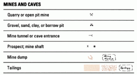
As far as I know, two crossed picks means it is a current mine, a X means it's abandoned, and there is another symbol for mineshaft as well.
TintedSnow
Full Member
- Sep 25, 2016
- 143
- 147
- Detector(s) used
- Equinox 800, White's Goldmaster
- Primary Interest:
- All Treasure Hunting
No. The symbol simply indicates a known mine. The evidence of a successful validity exam would be the certificate of determination itself. Many many mines will be found on topo maps that were never subject to exam or patent.
Heavy Pans
Heavy Pans
RobertF
Jr. Member
I'll mention most of them aren't precisely placed. While some are almost spot on, expect up to a 1500' or so margin of error (500' seems pretty regular). It all depends on what data source was used when the map was drawn. In the case of old shafts/adits, it's not unusual for them to just be retained each map revision with no one knowing if it was ever right to begin with. Your best bet is to try and track down a possible mine name and research it from there. Just don't be shocked when the original location notice is based off a "fixed" object like "the big pine tree at the top of the hill."
Top Member Reactions
-
 2591
2591 -
 1143
1143 -
 1060
1060 -
 903
903 -
 885
885 -
 851
851 -
 806
806 -
 695
695 -
 637
637 -
 547
547 -
 490
490 -
 477
477 -
 476
476 -
 464
464 -
 462
462 -
O
437
-
 425
425 -
 392
392 -
 380
380 -
 363
363
Users who are viewing this thread
Total: 2 (members: 0, guests: 2)


