mylandmatters.org

RattlingDan

Jr. Member
May 30, 2017
21
17
Oregon
Detector(s) used
Silver Sabre, AT Pro
Primary Interest:
All Treasure Hunting
Upvote 0

Goldwasher

Gold Member
May 26, 2009
6,077
13,225
Sailor Flat, Ca.
🥇 Banner finds
1
Detector(s) used
SDC2300, Gold Bug 2 Burlap, fish oil, .35 gallons of water per minute.
Primary Interest:
All Treasure Hunting
I use it constantly. I will be renewing my "caims advantage" membership.

You get reports of closed claims. In some states there are many. In California not so much.

I did it more to support Barry than to get the claim info.
 

DeepseekerADS

Gold Member
Mar 3, 2013
14,880
21,725
SW, VA - Bull Mountain
Detector(s) used
CTX, Excal II, EQ800, Fisher 1260X, Tesoro Royal Sabre, Tejon, Garrett ADSIII, Carrot, Stealth 920iX, Keene A52
Primary Interest:
Other
Thanks for posting the link.

I joined GPAA for one year only to get all their standard literature, and found there was virtually nothing there for us East Coast people. So I didn't re-subscribe.
 

Terry Soloman

Gold Member
May 28, 2010
19,419
30,082
White Plains, New York
🥇 Banner finds
1
🏆 Honorable Mentions:
1
Detector(s) used
Nokta Makro Legend// Pulsedive// Minelab GPZ 7000// Vanquish 540// Minelab Pro Find 35// Dune Kraken Sandscoop// Grave Digger Tools Tombstone shovel & Sidekick digger// Bunk's Hermit Pick
Primary Interest:
Metal Detecting
MLM is the premier site for information and getting the straight dope. You might also want to check out this page by Barry's better half!
Ripple Home Page
 

Bejay

Bronze Member
Mar 10, 2014
1,026
2,530
Central Oregon Coast
Detector(s) used
Whites GMT
Garret fully underwater
Primary Interest:
Prospecting
The advantage report is just that. It gives early notice as to what claims have been lost due to failures to fulfill the required performances and submittals to BLM and the Public Land Offices. The awareness that claims are subjected to being closed is simply the beginning of the process a miner must follow to re-acquire the open claim. One would think that might be fairly easy, but the reality is that it is not so easy. There are many issues that must be addressed and often many re-claimers simply do a paper filing without discovery. That makes it extremely difficult for the interested person wanting to verify discovery with an end result of ending up having a claim worthy of claiming. One must do boots on the ground to insure that they are not in a second fiddle position to someone else who has already begun the reclaiming. Once a new locator posts location papers they generally have 90 days to record said location at the land office....(there is a historical reason for the 3 month grace period). The newbie locator interested in the new open claim MUST put in a lot of effort to make sure someone else has not already beaten them to the punch (Oregon is the best example....as only a location doc has to be located somewhere on the claim)...(other states require corners etc). If someone has beaten you to the punch you have to watch and wait to see if the new claim locator records and notifies the BLM; who would create a file. Meanwhile lots of other knowledgeable interested parties are doing the same thing....waiting and watching. I would highly recommend that miners NOT get into a challenge issue over who has done the overclaiming....as that is simply a path of frustration and costs.
The trouble all comes from the paper miners who simply file claims without any boots on the ground and discovery...they simply want to acquire a claim.

If one wants a claim the issues that are entailed to locate are always the same...and the requirements do not change. There is lots of open ground out there...and some has never had a claim on it. I could actually lay claim to a lot of open ground that has never had a claim on it....it just takes a lot of knowledge and boots on the ground prospecting. I will offer the Oregon miners wanting a claim the following: Go buy the book Gold In Oregon......locate the lode claims and then go out and prospect the adjacent creeks where there is open public land. With todays new methods of recovery there are many remote creeks adjacent to historic lode claims that are left untouched because the old timers wanted the easy gold and did not have the new methods of recovery.

No doubt the gold rush is on and many are trying to rush into finding some gold....but My 45 years of experience have taught me one thing. You must know how to file a claim.....if you do learn and understand (Landmatters has all the details) you should be able to acquire a worthy claim and then you must do the performance dance that many fail to successfully do. Sep 1st deadline is fast approaching and many fevers of gold rush will ensue the mad dash. In some mining areas it gets downright ridiculous and the "wanting to simply go out and find some gold" entails a lot of heartburn; challenging the overclaiming.

I would always suggest patience vs rush...but that is almost impossible with the paper claimers of today and the inet miners.

Good Luck to all who venture down the public inet trail of mining!.....I am glad this old miner did it way before the net method came into existence.......one might name a claim "Mad Dash".

Bejay
 

M.E.G.

Sr. Member
Apr 25, 2014
498
875
Primary Interest:
All Treasure Hunting
BLM records are for it's internal usage/information pursuant to it's "DISCLAIMER:
NO WARRANTY IS MADE BY BLM FOR USE OF THE DATA FOR PURPOSES NOT INTENDED BY BLM"

Best to follow the law, respect a miner's property, and go to the county clerk for any current records. Don't waste everyone's time involved, you can't file over some one anyway. And remember, there is a statutory delay period whereby a claimant may intend to file but has not yet; That property "should" have monuments in the field.
 

Bejay

Bronze Member
Mar 10, 2014
1,026
2,530
Central Oregon Coast
Detector(s) used
Whites GMT
Garret fully underwater
Primary Interest:
Prospecting
MEG QUOTE "Best to follow the law, respect a miner's property, and go to the county clerk for any current records. Don't waste everyone's time involved, you can't file over some one anyway. And remember, there is a statutory delay period whereby a claimant may intend to file but has not yet; That property "should" have monuments in the field."[/QUOTE]

BLM has no records...they have their files
The point is well taken. But in Oregon the monument issue is elusive to say the least...as the placer claims are based on the Gov Survey. The notice of location can merely be attached to a tree. In Oregon there are lots of trees. Personally I always place the location notice in a very conspicuous place,,,,and that is where the claim is MOST ACCESSABLE to others. But I also have claims that are very remote and finding the exact tree is elusive to say the least. Secondly the notices are most often removed by people....and a constant vigilance is required to keep location notifications intact. Not all Oregon miners are so prudent. Lets just say the statutory delay period (90 days in Oregon) makes it even more ambiguous when one is in the fast lane of seek and conquer.

I can show many instances of over claiming and per Mining Law the only resolution is via the courts unless direct correspondence with an over claimer procures success. Of course the over claiming can be cited as unlawful but one must be aware that "occupation" of a claim (with mineral extractions) can make all those involved quite upset.

So bottom line "IMHO" is to go ahead and use "claims advantage" then go do the boots on the ground and check to see if there are any location notices or monuments. If none then go ahead a make the discovery and post your location notice...be sure to take pics with dates and have a witness to such. (it gets nasty out there with dated location notices superseding each one that gets put up.)....as the game gets nasty amongst those not very scrupulous.

Then go to the Land Office and check to see if by chance there has been another recording on the location. If none, then go ahead and proceed. Now we get down to the BLM status of (not a record) but their own files....as they make decisions on such matters. One thing is certain...the BLM loves to take your money and issue you their blessing if they can. As pointed out...there is no warranty brought forth by the BLM. Congress gave the BLM the duty of making sure fees and work are done......and that is it...plain and simple....that is why they have a file.

Bejay
 

Last edited:

Assembler

Silver Member
May 10, 2017
3,098
1,181
Detector(s) used
Whites, Fisher, Garrett, and Falcon.
Primary Interest:
Prospecting
"Corner Monuments"

BLM records are for it's internal usage/information pursuant to it's "DISCLAIMER:
NO WARRANTY IS MADE BY BLM FOR USE OF THE DATA FOR PURPOSES NOT INTENDED BY BLM"

Best to follow the law, respect a miner's property, and go to the county clerk for any current records. Don't waste everyone's time involved, you can't file over some one anyway. And remember, there is a statutory delay period whereby a claimant may intend to file but has not yet; That property "should" have monuments in the field.
Just pointing out the following that may be of interest:
The courts attach major importance to evidence relating to the original position of the monument, such evidence being given far greater weight than the record relating to bearings and lengths of lines. It is the purpose that the monuments shall serve every necessary requirement for the identification of the survey.
 

Assembler

Silver Member
May 10, 2017
3,098
1,181
Detector(s) used
Whites, Fisher, Garrett, and Falcon.
Primary Interest:
Prospecting
"Corner Accessories"

Hello
As a followup that may be of interest:
The purpose of an accessory is to evidence the position of the corner monument. A connection is made from the corner monument to fixed natural or artificial objects in its immediate vicinity, whereby the corner may be relocated from the accessory, thus in the event of the destruction or removal of the monument, its position may be identified as long as any part of the accessories remains in evidence.
 

Assembler

Silver Member
May 10, 2017
3,098
1,181
Detector(s) used
Whites, Fisher, Garrett, and Falcon.
Primary Interest:
Prospecting
Hello
Just asking if anyone reading this has a example on there own "Claims / Surveys" of (either or both) "Miscellaneous angle points along irregular boundaries or Intermediate corners along irregular boundaries"?
Thank you.
 

et1955

Hero Member
Jan 10, 2015
913
1,783
Shoreline,wa
Detector(s) used
Equinox 800
Primary Interest:
Prospecting
Hello
Just asking if anyone reading this has a example on there own "Claims / Surveys" of (either or both) "Miscellaneous angle points along irregular boundaries or Intermediate corners along irregular boundaries"?
Thank you.
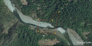
Is this what you are looking for #1.jpg
 

Assembler

Silver Member
May 10, 2017
3,098
1,181
Detector(s) used
Whites, Fisher, Garrett, and Falcon.
Primary Interest:
Prospecting
"Digital Base Drawing" ?

Is this what you are looking for View attachment 1488726
This is a "Digital Base Drawing" as well could be a "Digital Plat of Mineral Segregation Survey"
The following may shed some more ‘Light on the above topic':
5-4. The terms "corner" and "monument" are not interchangeable. A "corner" is a point determined by the surveying process. A "monument" is the object or the physical structure which marks the corner point.
The "corners" of the public land surveys are those points that determine the boundaries of the various subdivisions represented on the official plat - the township corner, the section corner, the quarter-section corner, the subdivision corner, or the meander corner. The "mile corner" of a State, reservation, or grant boundary does not mark a point of a subdivision; it is a station along the line, however, and long usage has given acceptance to the term. An "angle point" of a boundary marks a change in the bearing, and in that sense it is a corner of the survey.
https://www.blm.gov/cadastral/Manual/73man/id214.htm

As far as the “BLM” having just a “File” the following may be of interest:
The law provides that the original corners established during the process of the survey shall forever remain fixed in position, even to disregarding technical errors in the execution of the survey, where discrepancies may have passed undetected prior to the acceptance of the survey.
 

Assembler

Silver Member
May 10, 2017
3,098
1,181
Detector(s) used
Whites, Fisher, Garrett, and Falcon.
Primary Interest:
Prospecting
This is a "Digital Base Drawing" as well could be a "Digital Plat of Mineral Segregation Survey"
The following may shed some more ‘Light on the above topic':

As far as the “BLM” having just a “File” the following may be of interest:
This appears to be a drawing on Google maps. However "BLM" may have a 'Sub-layered drawing' that will have the "Miscellaneous angle points along irregular boundaries or Intermediate corners along irregular boundaries" on it. It is clear the 'Drawing on Google maps' has "Irregular boundaries'.
 

Assembler

Silver Member
May 10, 2017
3,098
1,181
Detector(s) used
Whites, Fisher, Garrett, and Falcon.
Primary Interest:
Prospecting
This appears to be a drawing on Google maps. However "BLM" may have a 'Sub-layered drawing' that will have the "Miscellaneous angle points along irregular boundaries or Intermediate corners along irregular boundaries" on it. It is clear the 'Drawing on Google maps' has "Irregular boundaries'.
By law the "Monument" has to have this information and has "Standing in court":
during the process of the survey shall forever remain fixed in position
 

Assembler

Silver Member
May 10, 2017
3,098
1,181
Detector(s) used
Whites, Fisher, Garrett, and Falcon.
Primary Interest:
Prospecting
Subject matter.

By law the "Monument" has to have this information and has "Standing in court":
Now one can get a idea just how important a "Monument" is:
The terms "Corner" and "Monument" are used largely in the same sense, though a distinction should be noted to clarify the subject matter.
 

Assembler

Silver Member
May 10, 2017
3,098
1,181
Detector(s) used
Whites, Fisher, Garrett, and Falcon.
Primary Interest:
Prospecting
43 C.F.R. sec. 3832.12 requires all mining claims and sites to be as compact and regular in form as reasonably possible and to conform to the U.S. Public Land Survey System and its rectangular subdivisions as much as possible.
To conform to the public land survey system, a placer mining claim must be described by aliquot part within the quarter section……
To meet the compactness requirement, BLM regs. require that the 40-acre square guidance be strictly applied to association placer mining claims described by metes and bounds.
Placer mining claims located on Federal land generally must meet three requirements: acreage, conformity, and compactness. A placer claim located by an individual claimant may not exceed 20 acres. 30 U.S.C. sec. 35 (2006); 43 C.F.R. sec. 3832.22 (b) (1).

VS.

"Miscellaneous angle points along irregular boundaries or Intermediate corners along irregular boundaries" on it. The courts attach major importance to evidence relating to the original position of the monument, such evidence being given far greater weight than the record relating to bearings and lengths of lines. It is the purpose that the monuments shall serve every necessary requirement for the identification of the survey.

The terms "corner" and "monument" are not interchangeable. A "corner" is a point determined by the surveying process. A "monument" is the object or the physical structure which marks the corner point.
The "corners" of the public land surveys are those points that determine the boundaries of the various subdivisions represented on the official plat - the township corner, the section corner, the quarter-section corner, the subdivision corner, or the meander corner. The "mile corner" of a State, reservation, or grant boundary does not mark a point of a subdivision; it is a station along the line,
however, and long usage has given acceptance to the term. An "angle point" of a boundary marks a change in the bearing, and in that sense it is a corner of the survey.
 

Last edited:

winners58

Bronze Member
Apr 4, 2013
1,729
4,058
Oregon
Primary Interest:
All Treasure Hunting
as miners we don't do survey's, when staking a claim a monument is the point of discovery,
then we provide a description and map that can be easily traced on the ground.
a monument in a survey is different and is tied to the township marker that is every 6 miles,
back before GPS and such you would have to find that marker and use a long tape measure and compass to mark your claim.
using survey terminology the way you are using it, and marking your claim doesn't work for the average miner.
 

Last edited:

Top Member Reactions

Users who are viewing this thread

Top