A review
Anyone who uses the BLM LR2000 search function knows it can be a challenge to get meaningful results. Often the service is down but you aren't notified of a problem with the system until you go through the whole complex search process to discover there was an "error". Frustrating at times.
Well it appears the BLM decided it was time to change the look and feel of the LR2000 search function. They notified users months ago that they were working on an improved version but they caught a lot of people by surprise when they introduced the NEW! IMPROVED! LR2000 on November 1 and shut down the functions of the OLD! BAD! LR2000 at the same time.
Problem was they didn't tell anyone. The old LR2000 still appears to be there and will allow you to do a search. That search returns an error, as mentioned earlier that's not unexpected or uncommon when using the LR2000. I use the LR2000 a lot when I need the most recent information on a land or claim case file. It took me nearly 24 hours after the changeover to get fed up enough with the old LR2000 not working to try the new LR2000 which has been available but not working for the last nine months. I'm hoping the BLM will set up that old LR2000 web address to redirect to the new LR2000 page so others won't have to waste their time beating a dead search system like I did.
The old LR2000 was clunky. It reminded me of an old unfamiliar broken down right hand drive truck with a Japanese language repair manual. It was really that awkward and counter intuitive. There were many blogs, manuals and videos devoted to explaining the esoteric mysteries of the BLM's version of public access to public records, I even helped write a few myself. I made good use of the old LR2000 on the days it was working and I was glad to have it when I could get results but it needed fixing.
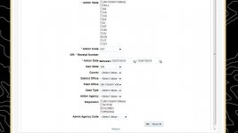
The new LR2000 has a cleaner less intimidating interface with a slightly simpler set of options. I really don't like the "black topo" background the BLM now puts on all their web pages. If you like the black topo theme you are probably going to like the look of these new search pages better than the old ones.
The behind the scenes search function has changed a lot from the old LR2000. I tried it on several browsers and three operating systems. I had problems on every browser and system. The Search seems to hang in some circumstances, in others it returns results as quickly as the old LR2000. The actual search itself seems to be slower sometimes. Every browser I tried had problems when it had run a few searches. The searches would eventually hang and several loops would keep the browser so busy it would lock up. That's not something I'm used to experiencing. This is a new system so I'm hoping the BLM will get these glitches out soon.
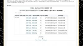
The results of each search now displays in a new interface. Essentially there will be a window frame on the results page with the document displayed inside the frame as a PDF. Like the old LR2000 there are options to download the document in several formats including Excel, PDF and HTML. You can now modify or start a new search from the results page.
Land Matters has made an effort to bypass the clunky old LR2000 interface and allow you to directly access any claims BLM serial register page directly with a few clicks on a map. This turned out to be a lot quicker way to get information on claims in a specific area without having to pound through the old LR2000. Being a direct live link to the BLM the information is as current as possible unlike other mapping programs that present static information updated every month or so.
When the unannounced changeover in LR2000 search systems happened it broke Land Matters system of direct access. With more than 380,000 mining claims being actively tracked Land Matters had a problem. Claims Advantage Members also get several reports a month. In the last two days Land Matters had released two reports with a combined total of more than 20,000 maps and direct links to a broken LR2000. That's 400,000 missing documents. Sometimes life can be.... interesting.
Needless to say I have been busy. It took 24 hours but I deciphered the new LR2000 system fixed the links to the serial register pages and corrected, compiled and uploaded new member reports. The mining claim serial register pages linked to on the maps load more quickly than the old ones did. If you have any problems with those maps or the Member Reports please let me know.
Please try out the new LR2000 and share your experiences here. Try the Mining Claims Maps at Land Matters and marvel at the new search results. If you like the way the map link system works we can add the feature for a lot more types of research.
Heavy Pans
Anyone who uses the BLM LR2000 search function knows it can be a challenge to get meaningful results. Often the service is down but you aren't notified of a problem with the system until you go through the whole complex search process to discover there was an "error". Frustrating at times.
Well it appears the BLM decided it was time to change the look and feel of the LR2000 search function. They notified users months ago that they were working on an improved version but they caught a lot of people by surprise when they introduced the NEW! IMPROVED! LR2000 on November 1 and shut down the functions of the OLD! BAD! LR2000 at the same time.
Problem was they didn't tell anyone. The old LR2000 still appears to be there and will allow you to do a search. That search returns an error, as mentioned earlier that's not unexpected or uncommon when using the LR2000. I use the LR2000 a lot when I need the most recent information on a land or claim case file. It took me nearly 24 hours after the changeover to get fed up enough with the old LR2000 not working to try the new LR2000 which has been available but not working for the last nine months. I'm hoping the BLM will set up that old LR2000 web address to redirect to the new LR2000 page so others won't have to waste their time beating a dead search system like I did.
The old LR2000 was clunky. It reminded me of an old unfamiliar broken down right hand drive truck with a Japanese language repair manual. It was really that awkward and counter intuitive. There were many blogs, manuals and videos devoted to explaining the esoteric mysteries of the BLM's version of public access to public records, I even helped write a few myself. I made good use of the old LR2000 on the days it was working and I was glad to have it when I could get results but it needed fixing.
The new LR2000 has a cleaner less intimidating interface with a slightly simpler set of options. I really don't like the "black topo" background the BLM now puts on all their web pages. If you like the black topo theme you are probably going to like the look of these new search pages better than the old ones.
The behind the scenes search function has changed a lot from the old LR2000. I tried it on several browsers and three operating systems. I had problems on every browser and system. The Search seems to hang in some circumstances, in others it returns results as quickly as the old LR2000. The actual search itself seems to be slower sometimes. Every browser I tried had problems when it had run a few searches. The searches would eventually hang and several loops would keep the browser so busy it would lock up. That's not something I'm used to experiencing. This is a new system so I'm hoping the BLM will get these glitches out soon.
The results of each search now displays in a new interface. Essentially there will be a window frame on the results page with the document displayed inside the frame as a PDF. Like the old LR2000 there are options to download the document in several formats including Excel, PDF and HTML. You can now modify or start a new search from the results page.
Land Matters has made an effort to bypass the clunky old LR2000 interface and allow you to directly access any claims BLM serial register page directly with a few clicks on a map. This turned out to be a lot quicker way to get information on claims in a specific area without having to pound through the old LR2000. Being a direct live link to the BLM the information is as current as possible unlike other mapping programs that present static information updated every month or so.
When the unannounced changeover in LR2000 search systems happened it broke Land Matters system of direct access. With more than 380,000 mining claims being actively tracked Land Matters had a problem. Claims Advantage Members also get several reports a month. In the last two days Land Matters had released two reports with a combined total of more than 20,000 maps and direct links to a broken LR2000. That's 400,000 missing documents. Sometimes life can be.... interesting.

Needless to say I have been busy. It took 24 hours but I deciphered the new LR2000 system fixed the links to the serial register pages and corrected, compiled and uploaded new member reports. The mining claim serial register pages linked to on the maps load more quickly than the old ones did. If you have any problems with those maps or the Member Reports please let me know.
Please try out the new LR2000 and share your experiences here. Try the Mining Claims Maps at Land Matters and marvel at the new search results. If you like the way the map link system works we can add the feature for a lot more types of research.

Heavy Pans
Upvote
0


