Government Lots

Rail Dawg

Sr. Member
Oct 11, 2015
491
890
Northern Nevada
Detector(s) used
MineLab GPZ 7000
Garrett ATX Pro
Primary Interest:
Prospecting
Note:

Just made another donation to mylandmatters.org

Question:

If a government lot shows up in the mylandmatters database but does not show up in the Earthpoint Townships database which one is correct?

A section I'm working on in Earthpoint Townships has aliquot parts shown whereas mylandmatters.org has it shown as Government Lot 1.

I knew this answer a couple months ago but like a dummy I didn't write down the answer like I do almost every time.

Any help appreciated.

(mylandmatters.org is close to their goal. Let's help them reach it. They are invaluable!!)
 

Upvote 0

Goldwasher

Gold Member
May 26, 2009
6,077
13,225
Sailor Flat, Ca.
🥇 Banner finds
1
Detector(s) used
SDC2300, Gold Bug 2 Burlap, fish oil, .35 gallons of water per minute.
Primary Interest:
All Treasure Hunting
lots are secondary plss

if the earthpoint doesn't show quarters ( and smaller) it won't show lots

just use MLM it's correct

Make sure you know how to claim a lot
 

OP
OP
Rail Dawg

Rail Dawg

Sr. Member
Oct 11, 2015
491
890
Northern Nevada
Detector(s) used
MineLab GPZ 7000
Garrett ATX Pro
Primary Interest:
Prospecting
lots are secondary plss

if the earthpoint doesn't show quarters ( and smaller) it won't show lots

just use MLM it's correct

Make sure you know how to claim a lot


Thanks for the info.

Yep had to learn how to claim lots the hard way but the lesson was learned lol.
 

bug

Full Member
Jun 5, 2008
236
392
Nor Cal
Primary Interest:
All Treasure Hunting
What did you goof on a lot claim? Any advice to get it done right?
 

Goldwasher

Gold Member
May 26, 2009
6,077
13,225
Sailor Flat, Ca.
🥇 Banner finds
1
Detector(s) used
SDC2300, Gold Bug 2 Burlap, fish oil, .35 gallons of water per minute.
Primary Interest:
All Treasure Hunting
Make sure you claim the whole lot and pay for every portion of 20 acres and locate properly.

44 acres = three locators

155 x 3 + 465 in first year maint. fees

Guy near me located wrong only two locators only 40 acres worth of fees. BLM hasn't caught it yet

They took his money when he turned in the paperwork wrong too.
 

OP
OP
Rail Dawg

Rail Dawg

Sr. Member
Oct 11, 2015
491
890
Northern Nevada
Detector(s) used
MineLab GPZ 7000
Garrett ATX Pro
Primary Interest:
Prospecting
Yes my first mistake with Government Lots cost me some coin and the BLM didn't send me a letter to fix it for almost a year.

Not slamming them they have a lot to do.
 

OP
OP
Rail Dawg

Rail Dawg

Sr. Member
Oct 11, 2015
491
890
Northern Nevada
Detector(s) used
MineLab GPZ 7000
Garrett ATX Pro
Primary Interest:
Prospecting
Now I do have a concern with something related to mylandmatters and the database being used for Earthpoint Townships (and the BLM).

When you look at mylandmatters maps there are Government Lots still being listed that were taken out of the Master Title Plat almost 40 years ago.

Earthpoint Township doesn't show these outdated Government Lots 1 only the Lots that are currently in place.

I was wondering why mylandmatters shows 2 "Lot 1's" out in Rye Patch (T32N R32E Section 18) and Earthpoint does not.

Not a slam on mylandmatters by any stretch.

Again it's been 40 years since those Lot 1's existed and I prefer to see the latest database that corrects for changes to the Master Title Plat?

Any help appreciated.
 

OP
OP
Rail Dawg

Rail Dawg

Sr. Member
Oct 11, 2015
491
890
Northern Nevada
Detector(s) used
MineLab GPZ 7000
Garrett ATX Pro
Primary Interest:
Prospecting
Make sure you claim the whole lot and pay for every portion of 20 acres and locate properly.

44 acres = three locators

155 x 3 + 465 in first year maint. fees

Guy near me located wrong only two locators only 40 acres worth of fees. BLM hasn't caught it yet

They took his money when he turned in the paperwork wrong too.


When I was made aware of my mistake by the BLM on my first Government Lot claims I decided to go ahead and fix a couple others that the BLM had not caught yet.

There's no sense having claims you know are not legal.

I had to do the whole Amended COL routine and submit new maps using metes and bounds.

It was a lot of work fixing all this but I learned a great deal.
 

OP
OP
Rail Dawg

Rail Dawg

Sr. Member
Oct 11, 2015
491
890
Northern Nevada
Detector(s) used
MineLab GPZ 7000
Garrett ATX Pro
Primary Interest:
Prospecting
What did you goof on a lot claim? Any advice to get it done right?

I used aliquot parts to define the lot.

N1/2 NW1/4NE1/4 Lot 5

We can't do that.

You have to start at a known point (usually a survey marker) and by using metes and bounds describe the claim.

If unable to find an exact bearing use “following the northern line of Lot X, head X feet to the X corner of the claim”.

If a corner is common with a Survey Marker say "Common with Survey Marker".

A contiguous claim block only needs one tie in. Tie the first claim in and then tie the second claim to the first, the third to the second and so on. As long as they share corners and you give a good metes and bounds description BLM should be able to find the claims.

I took a bunch of notes during my ordeal but in the end I'm glad it happened.

The lessons I learned were huge.
 

Goldwasher

Gold Member
May 26, 2009
6,077
13,225
Sailor Flat, Ca.
🥇 Banner finds
1
Detector(s) used
SDC2300, Gold Bug 2 Burlap, fish oil, .35 gallons of water per minute.
Primary Interest:
All Treasure Hunting
?

you can just claim by lot

lot 5 sec 11 twnsp# rng #


the main thing is the amount of locators and proper maintenance fees the first year.

if there's a lot there is a survey. a lot is an aliqout part of that survey

make it simple use the label they gave you.

I don't think you "had" to do metes and bounds.

Though your in Nevada and I could be wrong.
 

OP
OP
Rail Dawg

Rail Dawg

Sr. Member
Oct 11, 2015
491
890
Northern Nevada
Detector(s) used
MineLab GPZ 7000
Garrett ATX Pro
Primary Interest:
Prospecting
?

you can just claim by lot

lot 5 sec 11 twnsp# rng #


the main thing is the amount of locators and proper maintenance fees the first year.

if there's a lot there is a survey. a lot is an aliqout part of that survey

make it simple use the label they gave you.

I don't think you "had" to do metes and bounds.

Though your in Nevada and I could be wrong.


Unfortunately the requirement to do a metes and bounds description is required if the mining claim is 20 acres and the lot is bigger than that.

2 claimants can claim a lot (under 40 acres) and use the description you posted but for an individual claimant a lot needs to be subdivided.

Because it is subdivided placer claims cannot conform to legal subdivisions so survey and plat must be made as on unsurveyed lands.

That is what 30 USC 25 states.

Locations on unsurveyed lands REQUIRES a metes and bounds description.

43 CFR 3832.12 (c) requires that placer claims be described by aliquot part and COMPLETE lots using the PLSS.

43 CFR 3812.12 (b) states that an individual placer claim may not exceed 20 acres in size.

I don't think this is only a Nevada thing.

If others have filed claims on lots doing it the way I did it originally they are in error they simply haven't been called out on it by the BLM.

That doesn't make it right however and a claim-jumper could come in and possibly challenge the claim as defective.
 

Last edited:
OP
OP
Rail Dawg

Rail Dawg

Sr. Member
Oct 11, 2015
491
890
Northern Nevada
Detector(s) used
MineLab GPZ 7000
Garrett ATX Pro
Primary Interest:
Prospecting
The information I posted above is from the letter I received from the BLM adjudicator in Reno.

I carefully read his letter and agreed with what he was saying.

The regulations are clear in this regard although I'm listening if someone here has a different take on the reading of the regulations.
 

Goldwasher

Gold Member
May 26, 2009
6,077
13,225
Sailor Flat, Ca.
🥇 Banner finds
1
Detector(s) used
SDC2300, Gold Bug 2 Burlap, fish oil, .35 gallons of water per minute.
Primary Interest:
All Treasure Hunting
Legal Land Descriptions
Placer claims must be described by aliquot parts and complete lots unless they meet one of these three exceptions:
1. Located on unsurveyed Federal lands; 2. Gulch (ie bed of a river within steep, nonmineral canyon walls) or bench (ie terrace or former flood plains made of gravel or sediment or both on the valley wall or slope above the current riverbed, created when the river previously was at a higher topographic level than now) placer claims; or 3. Bounded by other mining claims or nonmineral lands.

a lot is a subdivision not technically a aliquot part I guess but still

If you are in a surveyed area and there is a labeled lot you have to claim the complete lot.

I think a lode claim within a lot may be the exception. Then you would have to do metes and bounds to claim the unclaimed surface deposit.
If you don't have enough locators you can't just claim what you want as an individual.

Within a lot.

we have a 44 and a 23 acre lot in our section BLM told us that the whole lot has to be claimed.


My validity manual is at my shop..I'm at home so I can't check what it has to say.

Not saying your wrong or I'm right. I will not say what a guy at BLM says is right either.:laughing7:

But, I read the above and it says COMPLETE lot.

I don't know how an area can be surveyed ..a subdivision created ...and then your supposed to treat that subdivision like the survey doesn't exist...that labeled the subdivision in the first place.
 

Last edited:

Clay Diggins

Silver Member
Nov 14, 2010
4,885
14,258
The Great Southwest
Primary Interest:
Prospecting
?

you can just claim by lot

lot 5 sec 11 twnsp# rng #


the main thing is the amount of locators and proper maintenance fees the first year.

if there's a lot there is a survey. a lot is an aliqout part of that survey

make it simple use the label they gave you.

I don't think you "had" to do metes and bounds.

Though your in Nevada and I could be wrong.

The laws of how to describe a claim are federal, the same in every State. Lots are specifically not aliquot. Aliquots are by law and by definition a regular division part. Lots are created because a regular division can not be created.

You can claim a whole lot by reference to it's legal description (i.e. Lot 7). If you are claiming only a portion of a lot you must describe it by metes and bounds.

Mining Act 1872
Lode Claims
SEC. 8. That the description of vein or lode claims, upon surveyed lands, shall designate the location of the claim with reference to the lines of the public surveys, but need not conform therewith.

Placer Claims
Section 10. where said placer-claims shall be upon surveyed lands, and conform to legal subdivisions, no further survey or plat shall be required, and all placer mining-claims hereafter located shall conform as near as practicable with the United States system of public land surveys and the rectangular subdivisions of such surveys, and no such location shall include more than twenty acres for each individual claimant, but where such claims cannot be conformed to legal subdivisions, survey and plat shall be made as on unsurveyed lands

From the Cadastral Survey (PDF) standards manual Specifications for Descriptions of Land For Use in Land Orders, Executive Orders, Proclamations, Federal Register Documents, and Land Description Databases

Lots are a legal subdivision of a section and designated by section and lot numbers such as “sec. 3, lot 1.” Lots cannot be described as aliquot.

Lots and other irregular tracts/parcels do not have aliquot characteristics. When they are subdivided there is a remainder. The uncertainty of the location of the remainder intended by the subdivision renders the description ambiguous and subject to more than one interpretation.

Metes-and-bounds descriptions are used to describe the boundaries of parcels that involve unusual applications of or departures from the rectangular system of the PLSS. In the PLSS, there are many special surveys of nonrectangular parcels, including mineral lode claims, forest homestead entries, private claims, small holding claims, ranchos, U.S. surveys, donation land claims, reservations, and congressionally designated areas.

So you are right that Lots can only be claimed as a whole but you are mistaken to think that a placer claim that is smaller than, but within a Lot, are not claimable. You are also correct in understanding that a lot can not be claimed by subdivisions like North 1/2 or SE quarter. Those placer claims that do not encompass the whole Lot must be located by metes and bounds.

Heavy Pans
 

Last edited:

Clay Diggins

Silver Member
Nov 14, 2010
4,885
14,258
The Great Southwest
Primary Interest:
Prospecting
Now I do have a concern with something related to mylandmatters and the database being used for Earthpoint Townships (and the BLM).

When you look at mylandmatters maps there are Government Lots still being listed that were taken out of the Master Title Plat almost 40 years ago.

Earthpoint Township doesn't show these outdated Government Lots 1 only the Lots that are currently in place.

I was wondering why mylandmatters shows 2 "Lot 1's" out in Rye Patch (T32N R32E Section 18) and Earthpoint does not.

Not a slam on mylandmatters by any stretch.

Again it's been 40 years since those Lot 1's existed and I prefer to see the latest database that corrects for changes to the Master Title Plat?

Any help appreciated.

I'm sorry I didn't see this before Dawg. I have an explanation for you but I'm not sure I can give you an answer.

The Earth Point PLSS appears to be the CadNSDI V1 as I pointed out before. The V1 was closed to changes in 2015, that data is static and will not be updated. The mapping for your section of interest is current to 2015

The Land Matters PLSS is the CadNSDI V2. The V2 is being updated virtually every month somewhere in the United States. The data changes. Nevada was last updated in May of 2017.

That's why the two maps don't agree. Different data with different dates. Neither one are the answer to your specific question but it does establish that the Land Matters data is the more current of the two.

So who's right?

I can't give you the answer but I can give you the tools to find out for yourself. It might take a while but the answers are available.

Here's what I found:

The MTP doesn't show Government Lots in that east half of the west half.
The multiple surveys only show two 80 acre strips occupying the North and South of that area.
There is no indication of quarter quarters being protracted in that area.

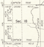
Here is the section shown in the most recent survey from 1978.
Screen Shot 2018-02-02 at 11.04.01 AM.png

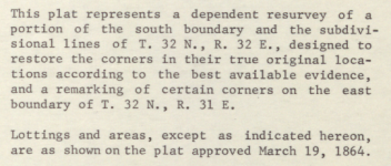
The scope of the survey and a pointer to the 1864 survey as authority for the subdivisions portion of the survey.
Screen Shot 2018-02-02 at 11.47.40 AM.png

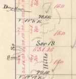
The 1864 survey
Screen Shot 2018-02-02 at 1.28.34 PM.png

All those seem to indicate that the area was never designated as a lot and was never surveyed for quarter quarters.
That would make the Land Matters PLSS wrong.

The problem is if that strip isn't broken down as quarter quarters on any map and it isn't designated a Government Lot what the heck is going on?
The place to find the details as to why a survey is made one way or another is to read the Survey Field Notes. Those will tell you why that area is so wacky.

Here link to the survey field notes for your area of interest. These field notes can be very revealing. They don't just have notes about pins and distances but they have a running description of the land and how it was being used. These handwritten notebooks can be difficult to navigate and a little confusing but I would suggest looking them over very carefully. I did a quick look and there are some pretty good notes on your area. Don't get so buried in reading about who lived where and where there were minerals being mined that you forget to look at the instructions for the survey. *wink* wink hint hint.

You think that the "Lot" designation was removed at some point but there is another possibility I'm guessing you hadn't considered - the land is still unsurveyed.

Looking at the documentation for the PLSS doesn't show any protracted survey in that Township. The entire Township has been surveyed including government lots and aliquots. That's why they assumed the strip was a government Lot. I think they may be wrong because I think I saw something in those survey field notes about instructions not to survey particular 80 acre strips. *wink ahh!*

On unsurveyed unprotracted lands you can claim by a logical regular unofficial protraction or metes and bounds. I usually locate all claims by both no matter which type of claim but set the lead page for the aliquot description for placers.

So who's right? I think I would go a little further and see why the cadastral survey now considers those strips to be lots and why the BLM doesn't. Armed with the information from your search that should be an interesting conversation. The answer you get there would answer your question ...maybe. I'll let you take it from here. :laughing7:

I do this type of research quite a bit. As you are beginning to understand land status can get pretty complex. I can tell you from experience that these types of information conflicts are very common. If you are going to locate claims you should be aware of potential conflicts before you locate. As you found corrections made later are painful.

Your continued support is much appreciated and your feedback on this issue and others is important information to help Land Matters bring you the information you need. Land Matters is working on tools to allow you to download all these documents directly from a map. Just trying to make all this a little easier. :thumbsup:

Heavy Pans
 

Last edited:
G

ghostminer

Guest
Great info. I have decided to join Land Matters. What is the dif between claims & corporate membership if I might ask?
 

Goldwasher

Gold Member
May 26, 2009
6,077
13,225
Sailor Flat, Ca.
🥇 Banner finds
1
Detector(s) used
SDC2300, Gold Bug 2 Burlap, fish oil, .35 gallons of water per minute.
Primary Interest:
All Treasure Hunting
good to know. The guys at the state office made it sound like you had to claim the whole lot. I'm not the only one they told.

I guess they wanted to make it "easier" for both parties. :laughing7: :BangHead:

So it is how you put it on paper too.

Like if you describe the lot but only claim it as 40 when its 44 you did it wrong.

I know of a claim located this way. For sure not metes and bounds.


My question is when you read what I copied about the exceptions that doesn't quite seem like it says that.

No gulch claim... no non mineral land adjacent.. there is a survey.

so why name exceptions?


It is frustrating that the guy behind the counter just says " oh that's a lot you have to claim the whole thing"

Reading up on it seemed to come up with the same conclusion.


I couldn't find anything that said.

"in order to claim a portion of a gov. lot the locator must make a description based on metes and bounds.

Only the aliquot part or complete lot info I shared.


when we did it, it was ok cause we wanted all of it any way.

I've always been confused about it couldn't get a strait answer or example to compare.
 

Last edited:

Goldwasher

Gold Member
May 26, 2009
6,077
13,225
Sailor Flat, Ca.
🥇 Banner finds
1
Detector(s) used
SDC2300, Gold Bug 2 Burlap, fish oil, .35 gallons of water per minute.
Primary Interest:
All Treasure Hunting
The mistake I made is that I thought a lot was a "legal subdivision" so it wasn't about it conforming.

So , if you want part of a lot that is not "conforming" so your naming what you claim by metes and bounds to locate it within those lot boundaries?
 

OP
OP
Rail Dawg

Rail Dawg

Sr. Member
Oct 11, 2015
491
890
Northern Nevada
Detector(s) used
MineLab GPZ 7000
Garrett ATX Pro
Primary Interest:
Prospecting
Clay your post above is a gold mine of good info.

Holy cow you can talk the talk on this stuff!

I'm impressed.

I only fixed the placer claims that were in Government Lots 3-6 by using metes and bounds.

The strip of land to the right of those Lots I was told by the BLM Reno are now aliquot so I followed their guidance.

But you brought up some very interesting points about exactly what was the intention not only of the original surveyor but the later revisions to the MTP.

Well done!
 

Top Member Reactions

Users who are viewing this thread

Latest Discussions

Top