corner post coordinates??

1637

Bronze Member
May 26, 2011
1,773
2,417
tujunga ca
Detector(s) used
xlt mxt gmz and now a gmt whites
Upvote 0

arizau

Bronze Member
May 2, 2014
2,484
3,867
AZ
Detector(s) used
Beach High Banker, Sweep Jig, Whippet Dry Washer, Lobo ST, 1/2 width 2 tray Gold Cube, numerous pans, rocker box, and home made fluid bed and stream sluices.
Primary Interest:
Prospecting
I just stay away from the quarter sections that have claims in them. Too lazy to go to the county recorder to look them up.
 

OP
OP
1637

1637

Bronze Member
May 26, 2011
1,773
2,417
tujunga ca
Detector(s) used
xlt mxt gmz and now a gmt whites
is it true that they run north and south ,east and west at true n not magnetnic north? 12 degrees?
thanks brad
 

arizau

Bronze Member
May 2, 2014
2,484
3,867
AZ
Detector(s) used
Beach High Banker, Sweep Jig, Whippet Dry Washer, Lobo ST, 1/2 width 2 tray Gold Cube, numerous pans, rocker box, and home made fluid bed and stream sluices.
Primary Interest:
Prospecting
Mark the section corners and quarter intersects and just stay away from the quarter sections that have claims in them. You can get those coordinates by using http://www.mylandmatters.org/. I do that rather than going to the county recorder to look them up.
 

Last edited:

Clay Diggins

Silver Member
Nov 14, 2010
4,883
14,247
The Great Southwest
Primary Interest:
Prospecting
Mining claims are located by aliquot part (legal land description) or by metes and bounds (compass direction and distance). There are no lat/lon or GPS coordinates in mining claim location. If you do see lat/lon on a location notice it would only be an "aid" and can't be relied on.

Go to the county recorder and get copies of the original location notices. From that information you can transfer the legal land description or direction and distance onto a topo map. :thumbsup:

Heavy Pans
 

Goldwasher

Gold Member
May 26, 2009
6,077
13,225
Sailor Flat, Ca.
🥇 Banner finds
1
Detector(s) used
SDC2300, Gold Bug 2 Burlap, fish oil, .35 gallons of water per minute.
Primary Interest:
All Treasure Hunting
A quarter section has 160 acres.... if it has a 20 acre claim there is still 140 acres available (if its public land)

yes you need to sort out what's claimed and whats not using the location description at the county..

I'm always interested in quarter sections with one or two small claims listed.

Good way to find good open ground....missed by the "lazy" guys..:tongue3:


just teasin AZ
 

arizau

Bronze Member
May 2, 2014
2,484
3,867
AZ
Detector(s) used
Beach High Banker, Sweep Jig, Whippet Dry Washer, Lobo ST, 1/2 width 2 tray Gold Cube, numerous pans, rocker box, and home made fluid bed and stream sluices.
Primary Interest:
Prospecting
A quarter section has 160 acres.... if it has a 20 acre claim there is still 140 acres available (if its public land)

yes you need to sort out what's claimed and whats not using the location description at the county..

I'm always interested in quarter sections with one or two small claims listed.

Good way to find good open ground....missed by the "lazy" guys..:tongue3:


just teasin AZ

My type of humor but "lazy"(?), also true.:laughing7:

My case: I discovered a unique situation that gives me over a section of historically productive ground to prospect unimpeded by claims since it is now closed to mineral entry. It is relatively close by and dry so I hike in my drywasher. So far "nuttin but cows" to contend with. For others not so lazy, you just have to learn how to and do the research at the county offices!
 

Last edited:

KevinInColorado

Gold Member
Jan 9, 2012
7,037
11,370
Summit County, Colorado
Detector(s) used
Grizzly Goldtrap Explorer & Motherlode, Gold Cube with trommel or Banker on top, Angus Mackirk Expedition, Gold-n-Sand Xtream Hand pump
Primary Interest:
Prospecting
My type of humor but "lazy"(?), also true.:laughing7: I on the other hand have the rare good fortune of having the availability of over a section of, historically, some of the most productive ground in the district (less than 10 square miles in total) now being closed to mineral entry. That, in my case, is a welcome exception. The closed to claiming land and otherwise "adjacent quarters without claims" land gives me plenty of territory to cover. For others not so fortunate, you just have to learn how to and do the research at the county offices!

Much of what cannot be claimed can still be dug! (Basis for my whole book)

To the OP: in addition to the individual county clerk/recorder offices, you also have the option of going to the State BLM office. They will also have copies of claim maps although very recent claims may still be on the way into their files.
 

Clay Diggins

Silver Member
Nov 14, 2010
4,883
14,247
The Great Southwest
Primary Interest:
Prospecting
I just stay away from the quarter sections that have claims in them.

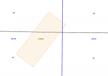
That can backfire on you arizau. The quarter section the BLM references the claim to may not be the area where the bulk of the claim is located. It can be a little hard to understand a wordy explanation of why this is so I made up a little graphic of this fairly common situation.

Screen Shot 2018-06-07 at 9.22.37 AM.png

This is an actual claim mapped in Arizona - one of hundreds that cross over Section and/or Township lines. You will notice that this now closed claim is across 3 sections (black lines) and two townships (blue lines). The entire claim is 600 feet X 1500 feet (20.66 acres). The largest part of the claim lies in 11N 1W Section 36. The second largest portion of the claim lies in the same Township but in Section 25. Just a little bit of the claim (about a quarter acre) lies in Township 11N 1E Section 30. Wanna guess which Township and Section the BLM references the claim to? Yep that smallest portion in the other Township is where the BLM will tell you the claim is located. :BangHead:

You would assume, if you are going by the BLM quarter section designation, that 11N 1E SW Section 30 was claimed and the other two sections were not.

There are at least a few 20 acre claims in Arizona that cover the corner of 4 Townships and 4 Sections. Only one of those 4 Townships and 4 Sections will be considered to be where the claim is located according to the BLM files. If you search the LR2000 for the other 3 Townships and Sections the result would show no claims there although the Serial Register page for each claim will show the different Sections and Townships.

The BLM is working to fix this problem but the results have been mixed so far so don't expect a reliable working system anytime real soon. From what I understand it's on the list of "fixes" but it's pretty far down that list.

One solution to the problem is to check all adjacent sections claims serial register pages. That takes a while but it can be very informative. I usually run a block of 9 Sections to check the claims placed by the BLM in any single section. That eliminates the possibility of missing crossovers and will give you a pretty good idea of groups that are claiming and the age of claims in the area, all good info to put in your research files before you spend time getting the County Location records for the claims in your area of interest.

If you are prospecting in most Arizona Counties you can get copies of the original location notices and maps as a free download online. It's an extra step that will reveal the errors that always seem to be a part of BLM case files as well as allowing you to know with some precision just what areas are claimed.

On the Land Matters Mining Claim maps we've gone to a mapping system where a claim gets assigned to every Section it's found in. That requires a lot more server space and time to create but we hope it will help researchers. The example in the illustration above would be mapped to three sections and 2 Townships at Land Matters. Also a little misleading but a valuable heads up about claim crossovers to the clever researcher. :thumbsup:

Heavy Pans
 

arizau

Bronze Member
May 2, 2014
2,484
3,867
AZ
Detector(s) used
Beach High Banker, Sweep Jig, Whippet Dry Washer, Lobo ST, 1/2 width 2 tray Gold Cube, numerous pans, rocker box, and home made fluid bed and stream sluices.
Primary Interest:
Prospecting
Woo. Maybe(?) I am safe since land matters is what I depend on.:thumbsup: Quoting you: "On the Land Matters Mining Claim maps we've gone to a mapping system where a claim gets assigned to every Section it's found in. That requires a lot more server space and time to create but we hope it will help researchers."

Thanks for the enlightenment.
 

Last edited:

Goldwasher

Gold Member
May 26, 2009
6,077
13,225
Sailor Flat, Ca.
🥇 Banner finds
1
Detector(s) used
SDC2300, Gold Bug 2 Burlap, fish oil, .35 gallons of water per minute.
Primary Interest:
All Treasure Hunting
That can backfire on you arizau. The quarter section the BLM references the claim to may not be the area where the bulk of the claim is located. It can be a little hard to understand a wordy explanation of why this is so I made up a little graphic of this fairly common situation.

View attachment 1599324

This is an actual claim mapped in Arizona - one of hundreds that cross over Section and/or Township lines. You will notice that this now closed claim is across 3 sections (black lines) and two townships (blue lines). The entire claim is 600 feet X 1500 feet (20.66 acres). The largest part of the claim lies in 11N 1W Section 36. The second largest portion of the claim lies in the same Township but in Section 25. Just a little bit of the claim (about a quarter acre) lies in Township 11N 1E Section 30. Wanna guess which Township and Section the BLM references the claim to? Yep that smallest portion in the other Township is where the BLM will tell you the claim is located. :BangHead:

You would assume, if you are going by the BLM quarter section designation, that 11N 1E SW Section 30 was claimed and the other two sections were not.

There are at least a few 20 acre claims in Arizona that cover the corner of 4 Townships and 4 Sections. Only one of those 4 Townships and 4 Sections will be considered to be where the claim is located according to the BLM files. If you search the LR2000 for the other 3 Townships and Sections the result would show no claims there although the Serial Register page for each claim will show the different Sections and Townships.

The BLM is working to fix this problem but the results have been mixed so far so don't expect a reliable working system anytime real soon. From what I understand it's on the list of "fixes" but it's pretty far down that list.

One solution to the problem is to check all adjacent sections claims serial register pages. That takes a while but it can be very informative. I usually run a block of 9 Sections to check the claims placed by the BLM in any single section. That eliminates the possibility of missing crossovers and will give you a pretty good idea of groups that are claiming and the age of claims in the area, all good info to put in your research files before you spend time getting the County Location records for the claims in your area of interest.

If you are prospecting in most Arizona Counties you can get copies of the original location notices and maps as a free download online. It's an extra step that will reveal the errors that always seem to be a part of BLM case files as well as allowing you to know with some precision just what areas are claimed.

On the Land Matters Mining Claim maps we've gone to a mapping system where a claim gets assigned to every Section it's found in. That requires a lot more server space and time to create but we hope it will help researchers. The example in the illustration above would be mapped to three sections and 2 Townships at Land Matters. Also a little misleading but a valuable heads up about claim crossovers to the clever researcher. :thumbsup:

Heavy Pans

I started teaching a class on using MLM to do claims research and what to do with the info found. As well as the claims process.

had a client in just a little bit ago.

We came across the very same thing I showed him how you couldn't tell from the on line file but, could look by checking the adjacent quarters ans see if the claim over lapped the lines.

while poking around in the nearby sections we found several large claims like two 80 acre a 120 acre and I think 160

All with only two locators.

Barry If i remember correctly you can't buy a claim with less locators than needed right?

It's always one locator per 20 even when you buy a claim right?
 

Clay Diggins

Silver Member
Nov 14, 2010
4,883
14,247
The Great Southwest
Primary Interest:
Prospecting
I started teaching a class on using MLM to do claims research and what to do with the info found. As well as the claims process.

had a client in just a little bit ago.

We came across the very same thing I showed him how you couldn't tell from the on line file but, could look by checking the adjacent quarters ans see if the claim over lapped the lines.

while poking around in the nearby sections we found several large claims like two 80 acre a 120 acre and I think 160

All with only two locators.

Barry If i remember correctly you can't buy a claim with less locators than needed right?

It's always one locator per 20 even when you buy a claim right?

If an existing placer claim of any size has a proven discovery it can be sold to one person. If the discovery, which the claim is based on, has not been proven the 20 acres per claimant still applies.

In most states transfers of placer claims that are more than 20 acres to one person will be challenged by the BLM within a month or two. They will send the claim owners a notice to provide proof of the discovery or reduce the claim to 20 acres per claimant.

In California they are years behind on their claim work and can barely keep basic claim files. California may never get around to challenging those claims even though the whole process for them is just three form letters. :BangHead:

And before you ask - No you can not independently determine whether the claim's mineral discovery has been proven.

Heavy Pans
 

Goldwasher

Gold Member
May 26, 2009
6,077
13,225
Sailor Flat, Ca.
🥇 Banner finds
1
Detector(s) used
SDC2300, Gold Bug 2 Burlap, fish oil, .35 gallons of water per minute.
Primary Interest:
All Treasure Hunting
Three claims in one section all over 80 acres transfer from proper associated claims to the same two people on all three.

The have been filing smw on them for like ten years

would the proof of discovery challenge show up on the registry if it had happened and it was deemed that all potions had the gold. or that the proper amendments in location size had been changed?

Just curious. Not gonna act on it. I was just showing the guy all the randomness you can discover when looking into claims.

What kind of proof of discovery to they look for/trust especially if they are leaving it up to the new owner?
 

Clay Diggins

Silver Member
Nov 14, 2010
4,883
14,247
The Great Southwest
Primary Interest:
Prospecting
Three claims in one section all over 80 acres transfer from proper associated claims to the same two people on all three.

The have been filing smw on them for like ten years

would the proof of discovery challenge show up on the registry if it had happened and it was deemed that all potions had the gold. or that the proper amendments in location size had been changed?

Just curious. Not gonna act on it. I was just showing the guy all the randomness you can discover when looking into claims.

What kind of proof of discovery to they look for/trust especially if they are leaving it up to the new owner?

The demand for proof and the response would show up on the Serial Register page. If there was no response or proof provided the claim would be closed. The owners do have the choice of reducing their claim to 20 acres per claimant if they can't provide proof of discovery.

Proof of discovery rests on the Prudent Man rule and it's subset the Marketability test. That's all pretty well established in law and in practice.

Heavy Pans
 

Goldwasher

Gold Member
May 26, 2009
6,077
13,225
Sailor Flat, Ca.
🥇 Banner finds
1
Detector(s) used
SDC2300, Gold Bug 2 Burlap, fish oil, .35 gallons of water per minute.
Primary Interest:
All Treasure Hunting
The demand for proof and the response would show up on the Serial Register page. If there was no response or proof provided the claim would be closed. The owners do have the choice of reducing their claim to 20 acres per claimant if they can't provide proof of discovery.

Proof of discovery rests on the Prudent Man rule and it's subset the Marketability test. That's all pretty well established in law and in practice.

Heavy Pans


thats what I figured I just didn't know if blm left it up to the new claimant to basically say.."gold... oh yea we got it and its everywhere... now leave us alone" :laughing7:

and no nothing in the registry after transfer of interest

just smw and aoe
 

Clay Diggins

Silver Member
Nov 14, 2010
4,883
14,247
The Great Southwest
Primary Interest:
Prospecting
thats what I figured I just didn't know if blm left it up to the new claimant to basically say.."gold... oh yea we got it and its everywhere... now leave us alone" :laughing7:

and no nothing in the registry after transfer of interest

just smw and aoe

If there's nothing in the Serial Register then the BLM has done nothing. ALL actions are listed there. A contact over claims status is an action.

I see proof challenges several times a month in other western states. In California I've never seen one. Your State BLM office is still working on basic location postings from several years ago. They do all prospectors a huge disservice by not even attempting to meet their obligations regarding mining claims.

Heavy Pans
 

Goldwasher

Gold Member
May 26, 2009
6,077
13,225
Sailor Flat, Ca.
🥇 Banner finds
1
Detector(s) used
SDC2300, Gold Bug 2 Burlap, fish oil, .35 gallons of water per minute.
Primary Interest:
All Treasure Hunting
We also came across several lots of incremental acerage I.E. 23.5...42.3 acres etc. That only enough locators for 20 or 40 etc.

Several of them

The amount of money Blm has gotten on these claims is crazy

Sucks it takes so long for them to let people know their claims aren't located properly.

It should null their disclaimer
 

Top Member Reactions

Users who are viewing this thread

Top