New to gold panning, need advice on Briceburg area bridge on Merced river CA

firebird

Full Member
Oct 17, 2018
230
311
Central Valley California
Primary Interest:
All Treasure Hunting
Hello, new member here. After watching too many Gold Rush episodes I ended up wanting to find some gold for myself too. The Briceburg bridge area along the Merced river is the closest place that Google tells me that I can find gold, but I can't find any accurate info on just where exactly can I pan for gold and which areas are off limits and are already owned by claims. I've already been to the area years ago in the camping grounds with family so I know how to get there. Can anyone help? Thanks in advance.
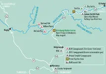
Merced-River-Campgrounds-Map.png
 

Upvote 0

N-Lionberger

Bronze Member
Dec 1, 2013
1,365
1,959
Arcata, California
Detector(s) used
Fisher 1212-x
Fisher Gold Bug 2
Whites 4900/SP3
Dowsing rods
Primary Interest:
Prospecting
There is a treasure thread somewhere on this forum that entails that area.
 

OP
OP
F

firebird

Full Member
Oct 17, 2018
230
311
Central Valley California
Primary Interest:
All Treasure Hunting
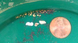
Thanks guys. Well after several days and what I estimate to be around 20 hours of really backbreaking work, this is all I found in the Briceburg area. Most of the gold was flour sized, only 6 pieces were big enough to be even picked up with tweezers. A bit discouraging but I spent a lot of time just trying to find spots where there was enough gold even big enough to see. I did find these odd grey/white-ish flakes though that seem metallic. They had weight however but it's easy to bend and really soft. What is it?

IMAG0782.jpg
 

OP
OP
F

firebird

Full Member
Oct 17, 2018
230
311
Central Valley California
Primary Interest:
All Treasure Hunting
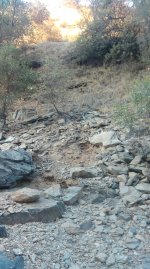
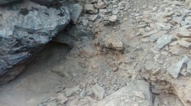
Also I noticed on the higher level of the riverbank near the dirt road, the rocks were different. It was in flake-like chunks and the soil was red. Someone had also been prospecting here too and cleaned out the gravel underneath the big rock completely. When I tried testing the flaky rock/gravel stuff it was like red clay-ish material. Really sticky and took more time than usual just to clean it out from sticking on the big rocks. However there was a lot of black sand with it and I even saw some tiny flour-sized gold. Is this significant gold-bearing material?

1.jpg 2.jpg
 

N-Lionberger

Bronze Member
Dec 1, 2013
1,365
1,959
Arcata, California
Detector(s) used
Fisher 1212-x
Fisher Gold Bug 2
Whites 4900/SP3
Dowsing rods
Primary Interest:
Prospecting
The white colored things look like lead to me. The best test is to pan out a known quantity of dirt to rough determine the gold content of a yard of dirt, a 5 gallon bucket works well for this.
 

Last edited:

OwenT

Hero Member
Feb 11, 2015
572
858
Moses Lake WA & Provo UT
Primary Interest:
Prospecting
Great job. You made out a lot better than I did my first trips out. Then again you are lucky because you're in the golden state. The white is almost definitely lead. You're for sure going to want to read all the stories that you can out of that thread "The Many Lost Treasures of Mariposa, CA (Photos Added)"
 

spillercanyon

Sr. Member
Jan 4, 2012
269
466
California
Primary Interest:
Prospecting
Hey Firebird,

That's some of my tromping grounds.

This map should help: https://www.blm.gov/sites/blm.gov/f...om-california-merced-river-recreation-map.pdf . It shows where the grandfathered claims are, the rest of the public land is open to prospecting. I sluiced just below the Sweetwater creek and Merced river junction (just above Briceburg) last year and did decent. We dug among the larger rocks and found gold in the top two feet of material (flood gold). You can hit the areas downstream past the drive-able road by hiking or riding a mountain bike down the old railroad grade. It may be tough to cross the North Fork Merced in the spring.

You say you are new to prospecting in which case you did pretty well. You'll do better as time goes, there's a non ending learning curve on where to dig. Try to pan areas that are less than picture perfect examples of where to dig, they have been dug on a regular basis, try something a bit less obscure. Test your theories, especially when you are new at it, I've been panning for 40 years and I still test my theories. I test most everywhere, even when I don't give it a lot of hope, I've been surprised more than once. If the pack is lose, move on. As you get practice it gets easier to tell what's been worked recently and what has not.

Good Luck!
 

Last edited:

Clay Diggins

Silver Member
Nov 14, 2010
4,885
14,258
The Great Southwest
Primary Interest:
Prospecting
Good information! :thumbsup:

Your link is dead spiller canyon. The BLM made a new map that just shows the river as a red "warning area" with no indication there are mining claims. You can see that new map HERE.

The BLM never did show a map with the mining claims but they did have a map that showed (kind of - sort of) the areas on the river that are claimed. They still have a copy of that map stashed away HERE or HERE. You might want to grab a copy before they disappear that too. :thumbsup:

Heavy Pans
 

spillercanyon

Sr. Member
Jan 4, 2012
269
466
California
Primary Interest:
Prospecting
Good information! :thumbsup:

Your link is dead spiller canyon. The BLM made a new map that just shows the river as a red "warning area" with no indication there are mining claims. You can see that new map HERE.

The BLM never did show a map with the mining claims but they did have a map that showed (kind of - sort of) the areas on the river that are claimed. They still have a copy of that map stashed away HERE or HERE. You might want to grab a copy before they disappear that too. :thumbsup:

Heavy Pans

Hey Clay,

I had just copied this off of the BLM website, I had just forgot the .pdf at the end of the link, it is working now. The map you directed me to is the high water flows for rafting. The Merced has zero dams above Lake McClure so this area is susceptible to whatever Mother Nature throws at it.
 

Clay Diggins

Silver Member
Nov 14, 2010
4,885
14,258
The Great Southwest
Primary Interest:
Prospecting
Hey Clay,

I had just copied this off of the BLM website, I had just forgot the .pdf at the end of the link, it is working now. The map you directed me to is the high water flows for rafting. The Merced has zero dams above Lake McClure so this area is susceptible to whatever Mother Nature throws at it.

Yeah I've worked that area extensively. The high flows are seasonal. I've worked a lot in that water blasting in the 70's and it can be treacherous when there are high flows.

Heavy Pans
 

spillercanyon

Sr. Member
Jan 4, 2012
269
466
California
Primary Interest:
Prospecting
Yeah I've worked that area extensively. The high flows are seasonal. I've worked a lot in that water blasting in the 70's and it can be treacherous when there are high flows.

Heavy Pans

I learned to pan on Bear Creek in '75 at Octagon. I may have seen you down on the river, it's where I learned what a dredge was and how it worked. Back then it was all skinny dipping and digging, I don't recall the date but I'm sure of the time, it was 4:20.

Thanks again Clay for sharing your knowledge with all of us, if I could just download it somehow.
 

Top Member Reactions

Users who are viewing this thread

Top