What satellite technology/software is being used by geologists, if any?

BoydBros

Jr. Member
Jul 28, 2019
47
39
Arizona
Detector(s) used
MineLab GoldMonster 1000
Garrett ATX
Primary Interest:
Prospecting
Are there any satellite tech/software being used to identify formations/faults etc?

Other than google earth. I've seen some pretty cool stuff on the TV from scientist studying IR imaging of foliage, crops and ground cover, even the oil/fossil fuel industry using sat imagery, is something similar being used for identifying geological formations?
 

Upvote 0

Mgumby16

Full Member
Jun 26, 2014
204
326
East Coast
Primary Interest:
Prospecting
BoydBros -

Geology is still a very boots on the ground science. While new advances in LIDAR and geophysics can help identify possible areas of interest they all still generally require ground truthing and a lot of times drilling to confirm what is showing up on the various geophysics instruments.

For example we had an earthquake in Mineral Virginia back in 2011, and since then the one USGS geologist i know has done extensive field mapping of the areas surrounding the earthquake. From this they have made updated and incredibly in-depth geologic maps. And while lidar has been used to identify linear trends and other large features, there are simply no substitutes for walking the ground taking samples and observations and creating geologic maps from that.

If your interested in the subject i suggest reading the book Intrepid Explorer by David Lowell. He is one of the best profitable mine finders of the 20th century and a hardcore believer in you need boots on the ground to find profitable mines followed by lots of core drilling. Its a good read.
 

bug

Full Member
Jun 5, 2008
236
392
Nor Cal
Primary Interest:
All Treasure Hunting
Lidar will show everything on the ground under the trees. Old ground sluices and shafts are no longer hidden in the vegetation.
Problem is the imagery is hard to find for many areas, at least thats my experience here in CA motherload.
 

Last edited:

Clay Diggins

Silver Member
Nov 14, 2010
4,883
14,247
The Great Southwest
Primary Interest:
Prospecting
Lidar is done with aircraft - not satellites. Same is true of magnetic surveys etc.

ICESat-2 is the best (only?) LiDAR satellite data to date. It's best scan resolution is one point measurement every 4.2 miles. Definitely not high resolution.

Satellites are incapable of high resolution imaging. Outside of TV dramas there is no such thing as reading auto license plates from space or "zoom and sharpen". The best satellite elevation measurements are about 100 foot resolution (30 meter) between measured points.

No satellite or aircraft can "see" beyond the earth's surface. That's a basic limitation of physics so that problem won't be solved soon.

There is good information out there in the form of boots on the ground geology. Many thousands of great geology maps and reports are available for any area in the U.S. - that's where your research will pay off. :thumbsup:

Heavy Pans
 

Last edited:

Goldwasher

Gold Member
May 26, 2009
6,077
13,225
Sailor Flat, Ca.
🥇 Banner finds
1
Detector(s) used
SDC2300, Gold Bug 2 Burlap, fish oil, .35 gallons of water per minute.
Primary Interest:
All Treasure Hunting
Lidar will show everything on the ground under the trees. Old ground sluices and shafts are no longer hidden in the vegetation.
Problem is the imagery is hard to find for many areas, at least thats my experience here in CA motherload.

problem is a lot of scanning needs to be done at or close to ground level. I'm pretty sure the vast majority of the pictures on the intrawebs that look awesome. Ruins under Mexico City. Seen even though there's a store there? Temples under vegetation and modern topsoil. They all require a lot of boots on the ground.

There is a lot (majority) of field/ground work and manual data entry to make this
https://en.wikipedia.org/wiki/File:Lidar_P1270901.jpg

into this.https://en.wikipedia.org/wiki/File:Effigy_mounds_lidar.jpg Combining Ariel scans with ground scans make the best images. I think Chapparal would make Lidar pretty crappy without a lot of ground scanning.
I do wish we could get good images of our area. Maybe harbor freight has those scanners:laughing7: I'm sure they'll take my 20% off coupon those things can't be cheap.
 

Last edited:

Tahoegold

Sr. Member
Mar 7, 2016
304
303
Carson City, NV
Detector(s) used
Compadre, Gold Racer, White's TRX,Bazooka GT 24",God Hog mats,Grizzly Gold Trap Motherload, Harbor freight 9 function, Cintech pinpointer, Determination
Primary Interest:
Prospecting
Very interesting question. There's a famous gold country geologist that describes the motherload. He says it's along a fault line. He goes on to give examples of minor faults where gold has been discovered in the California foot hills and describes the geology related to gold deposits. With that in mind. This may be useful info...

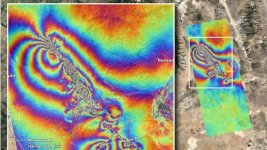
NASA Scientists Map Ground Damage Caused by California Earthquakes

NASA experts used satellite data to map the ground displacement caused by the two major earthquakes that struck Southern California on July 4 and 5, 2019.

Two*recent Southern California earthquakes*warped the ground across dozens of square miles — and the changes are visible even from space.*

A Japanese satellite picked up damage from the July 4 and 5 earthquakes that had magnitudes of 6.4 and 7.1, respectively. Quakes of these magnitudes are strong enough to cause moderate to severe damage to buildings.

The July 5 earthquake was the strongest to hit the Ridgecrest region (150 miles, or 241 kilometers, northeast of Los Angeles) in 40 years, according to the U.S. Geological Survey. The surface displacement caused by this temblor and its predecessor is clear in new images from Japan's Advanced Land Observing Satellite (ALOS-2) satellite.

That satellite gathers data using a technique called synthetic aperture radar, which produces detailed measurements of the height of Earth's surface. Scientists at NASA's Jet Propulsion Laboratory (JPL), which is also located in Southern California, created a map based on the data.

Each color band represents 4.8 inches (12 centimeters) of ground displacement within the radar instrument's line of sight, JPL*said in a statement. The most "noisy" areas, which appear the most muddled in the image, are likely where the ground was broken up by the earthquake. In the southeast corner of the image, linear features appear to slice through colored whirls and likely mark where the surface was sliced open by the quakes.

The USGS and the California Geological Survey, as well as other scientists, will use the map to assess damage and map the new faults. The region has also experienced 1,000 aftershocks that opened up a few cracks.

IMG_20190816_205434.jpg
 

Tahoegold

Sr. Member
Mar 7, 2016
304
303
Carson City, NV
Detector(s) used
Compadre, Gold Racer, White's TRX,Bazooka GT 24",God Hog mats,Grizzly Gold Trap Motherload, Harbor freight 9 function, Cintech pinpointer, Determination
Primary Interest:
Prospecting
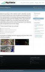
Here's a site that maps minerals using sattelites. It looks very complicated.
IMG_20190816_211612.jpg
 

Tahoegold

Sr. Member
Mar 7, 2016
304
303
Carson City, NV
Detector(s) used
Compadre, Gold Racer, White's TRX,Bazooka GT 24",God Hog mats,Grizzly Gold Trap Motherload, Harbor freight 9 function, Cintech pinpointer, Determination
Primary Interest:
Prospecting
It seems one sattelite has the capability to see minerals...

To aid mining operations in their search for suitable sites and to simply keep a long-term record of the world’s resources, the U.S. Geological Survey (USGS) two years ago initiated the Global Mineral Resource Assessment Project. The goal of the project is to construct a series of reports outlining where the world’s known metal ore deposits such as gold, copper, and iron occur and where new deposits are likely to be found.

As part of this ambitious effort, geologist Larry Rowan and a team of researchers at the USGS are now developing ways to locate potentially mineralized areas from space. Using the new Advanced Spaceborne Thermal Emissions and Reflection Radiometer (ASTER) instrument aboard the Terra satellite, they are attempting to find areas likely to contain copper in Iran and western Pakistan. If their tests are successful, then ASTER and future satellites could aid geologists in pinpointing any number of metal ores from aluminum to tin.
*

*

Tailing piles rise beside the abandoned buildings of the Kennecott Copper Mine in Alaska. This mine site was discovered when prospectors spied unusual green rocks. New satellites are allowing modern-day prospectors to map mineral deposits from afar. (Image courtesy*Historic American Engineering Record)

“For now, ASTER is really the only practical solution. It is the only instrument up there with the combination of spectral capability and geographic coverage to locate potentially mineralized areas on a global or regional scale,” says Rowan. He explains that mapping the world’s minerals could not be accomplished on the ground or by airplane alone. The costs would be enormous. The only feasible way to carry out such a large survey is through the use of remote sensing satellites. The problem with previous satellite instruments, however, was that while they could view large sections of the Earth, they didn’t have the ability to detect the geological information needed to reveal metal ore.

The ASTER instrument, launched aboard NASA’s Terra satellite in December 1999, was designed in part to remedy this problem. The instrument moves in a nearly circular orbit approximately from pole to pole around the Earth and measures a wide range of visible and infrared solar radiation from the surface of our planet. ASTER has a spatial resolution of up to 15 meters and can gather stereoscopic (3-D) images of the Earth, making it ideal for mapping mountains and rock formations.

Rowan and the USGS team decided to test ASTER’s abilities in mapping copper ore. Used in everything from electrical systems to compact discs to air conditioners, copper is one of the more expensive and useful non-precious metals. As a proving grounds, the USGS team turned their attention to a string of known copper deposits located across a 500-mile-long arc that extends from the northwest corner of Iran through the Zagros Mountains and into western Pakistan. Since this area is cloud free most of the year and many of the deposits have been mined since the beginning of the Bronze Age, the region is ideal for trying out ASTER.

“The types of deposits that lend themselves to remote sensing in Iran are intrusive deposits,” says Rowan. He explains that intrusive ore deposits form deep underground. Magma from the Earth’s mantle percolates into the Earth’s crust in areas where two tectonic plates collide or above “hotspots” in the mantle. As this magma solidifies to create rocks such as granite, the intense heat and pressure sometimes acts in concert with underground water to forge copper deposits at the boundary between the cooling magma and the existing crust. In Iran, the intrusive deposits first took shape between 10 and 70 million years ago at the boundary of the Arabian Plate and the Eurasian Plate. The copper deposits formed thousands of feet under the Earth’s surface. Continued uplift and years and years of water, ice, and wind erosion have exposed the copper ore to the Earth’s surface for mining.

In looking for such intrusive deposits, geologists must focus in on those large features such as faults and folds and mountains that indicate possible ore-bearing intrusive rocks. In ASTER images, such large-scale features are usually readily apparent. Narrowing the search to specific locations among these intrusive rocks, however, is considerably more involved. Like most metals, copper doesn’t exist in abundance on the Earth’s surface. In fact, copper only makes up 0.00007 percent of the Earth’s crust. So even in areas where deposits are common, copper is not easy to spot.

“What we do is look for other minerals that generally indicate that copper is in the region,” says Rowan. Fortunately, the same geothermal processes that create copper deposits usually give rise to other minerals, known as alteration minerals, that tend to be more abundant and more noticeable. Minerals such as muscovite, alunite, kaolnite, and iron sulfide are typically found in abundance around copper deposits. Some of these, such as iron sulfide, react with surface water and oxygen to form highly visible markers (Rowan et al. 2002). “If you’ve ever been to an old mining site in Colorado, the presence of the resulting sulfates can be seen in the yellowish to brown red cast they leave in the water,” says Rowan.

Though uncovering alteration minerals is much easier than finding an isolated copper vein, geologists still must go around collecting, testing for, and mapping the alteration minerals in large rock formations. ASTER, however, should be able to significantly reduce the amount of work and cost involved in this process. All told, ASTER can detect 14 different wavelengths (colors) of light reflected and emitted from the surface of the Earth. Generally, everything on the Earth’s surface reflects certain colors of light and absorbs others. Green grass, for instance, absorbs all colors in the visible spectrum except green. Alteration minerals, though usually much more subtle in color, absorb and reflect specific bands as well. Rowan explains that nine of the satellite instrument’s sensors that detect light in the visible and near-infrared (light past red on the color spectrum) range are particularly sensitive to the wavelengths associated with alteration minerals.
 

Moesia

Full Member
Oct 26, 2016
207
127
Primary Interest:
Other
Satellites don't work in exploration geology for the simple reason that they cannot penetrate vegetation. So they cannot be used on any terrain that is covered in grass, plants, or regolith. On the terrain that you can use them you have to know what you are looking at. Imagery that you produce from these satellites are nothing more than color images. After you get them then you than have to manually input what each color represents. To know what each color represents, you have to send someone to go and collect ground information of the surface geology which defeats the purpose. Using this kind of processed imagery on some patch of the earth in the middle of nowhere will get you nowhere. Only place where this kind of imagery is sometimes used is around existing mines in arid regions to aid with the mapping of surface alteration. This is not a new thing, it has been around for 40 years. This same story keeps recycling every 10 years for whatever reason.

ASTER and what you are describing from that article is 15 years old. Considering it was done in Iran of all places points to the fact that this had nothing to do with geology or mineral exploration. You could have done this same thing in the Andes or arid areas of the US, both of which are copper/base metal prolific.
 

OP
OP
B

BoydBros

Jr. Member
Jul 28, 2019
47
39
Arizona
Detector(s) used
MineLab GoldMonster 1000
Garrett ATX
Primary Interest:
Prospecting
I'm watching "How the Universe works" and they showing SATELLITES doing exploration geology of PLANETS ... weird that a few on this thread state they can't ...

I'm fairly convinced that there are SATs in orbit around our big blue rock, doing this very thing, for those with a boatload of money to exploit this tech
 

oneguy

Sr. Member
Aug 26, 2015
415
1,415
Montana
Detector(s) used
2 Goldmonsters, SDC 2300
Primary Interest:
Metal Detecting
The co. I work with, like already mentioned above, uses boots on the ground, lidar, core drilling, 3 geo's also chasing some faults and examine any specimens/nuggets I turn up.....
 

russau

Gold Member
May 29, 2005
7,266
6,723
St. Louis, missouri
In addition to what Tahoegold posted about Hyvista , Our Government back in the old days (pre 2000)used Landsat Satellites to "see" the probabilities of certain minerals ,Gas ,Water ETC underground. Later it used aircraft and back in 2000 when I was in Alaska I picked up a Engineering Magazine that had a several page article on this method of locating minerals . It was call Air Born Imaging System (AIS) and all they did was fly over some land (Mowing the lawn) and read the data when the get back to their base. then they would put the boots to the ground and verify(Spectrometer ???) their data . The article said they were currently scanning the United States for gas, oil ,and Water........ Do a goggle search on Air Born Imaging System and see what you come up with. I would imagine that big mineral / gold company's would still use this TechKnowledgy .
 

Clay Diggins

Silver Member
Nov 14, 2010
4,883
14,247
The Great Southwest
Primary Interest:
Prospecting
This fascination with satellite imaging is almost entirely due to television dramas. Let's look at the actual satellite imaging possibilities.

First a real life test to demonstrate the problem. Try this - take a picture of your license plate outside with your phone. Now move a mile away from that license plate and take another picture with your phone. Look at both pictures. Can you see as much detail in the picture from further away? Can you read the license plate from a mile away?

Now consider this - all the the Hubble space telescopes have lower pixel resolution than your phone.

If you can't take a picture of a license plate from a mile away with your phone and read the numbers why would you think you could take a picture from the closest low earth orbit satellite 1200 miles away and read a license plate - much less spot a mineralized vein? That's 1200 miles of atmosphere, dust and clouds. Not gonna happen.

Even the best low earth orbit satellites don't have single image resolution good enough to recognize the model of a car much less read their license plate. This is due to a law of physics known as the law of diffraction, specifically the circle of confusion limits the resolving power of any imaging system whether the images are based on visible light or some other form of energy. The longer a lens is (magnification) the worse the diffraction.

These are real physical limits the universe imposes. Any imaging system that could produce a higher resolution image could not be a physical device. That's why the TV dramas can read a license plate from space - the camera that does that exists only in the writers mind - it has no physical existence. In other words it doesn't exist in our world but it obviously can be believed by millions of television viewers.

There are some really good uses for satellite imaging. It's never high resolution imaging but for some subjects resolution isn't really that important. Things like gravity mapping or composite cloud mapping are perfect for satellite imaging. :thumbsup:

Heavy Pans
 

Last edited:

ZombieKnot

Jr. Member
Dec 25, 2022
82
78
Horse Hockey. Have worked with Australian miner that used satellite spectrography(SP?) to find a single mineral that starts with a B- name, not telling, that only appears on earth surface WITH GOLD DEPOSITS. He worked for 7 months mapping Australia; the whole continent. The company found a Quartz rift over 3 miles long in one case, that could not be seen from helicopters. Cost me a bottle of MacAllen to be shown one map of the Victoria mine fields and "places" were missed.. Then they went to other countries and have started mines or sold their findings. How did they get so big: satellite prospecting backed by three dimensional seismic. Eyes in the sky 1st, then and only then boots on the ground. B2GOLD was started like this, I'm told. How are all these cities, ruins, and roads in south america being revealed UNDERNEATH all those forests? If a satellite can determine how deep a river is, and its past meanderings for a thousand years; I think they could locate a mineral or two....
 

Top Member Reactions

Users who are viewing this thread

Top