Google earth coordinate errors....

Jan 25, 2012
7
0
Statesville, NC
Detector(s) used
MXT Pro,AT Pro,F75LTD
Primary Interest:
Metal Detecting
i am using the free version but I would think the coordinates would be accurate. I have marked several spots in google earth, then I put my curser on the location and input the coordinates to my garmin montana. After hitting the field I have noticed the coordinates are off by 1/4 mile or more in some locations. Im talking not even in the ball park. May I be doing something wrong or is this a google earth error? Im sure the garmin montana is working properly. Thaks for any help in advance!

Wayne
 

TerryC

Gold Member
Jun 26, 2008
7,732
10,990
Yarnell, AZ
Detector(s) used
Ace 250 (2), Ace 300, Gold Bug 2, Tesoro Cortes, Garrett Sea Hunter, Whites TDI SL SE, Fisher Impulse 8, Minelab Monster 1000, Minelab CTX3030, Falcon MD20, Garrett Pro-pointer, Calvin Bunker digger.
Primary Interest:
Metal Detecting
Your error problems are a very common problem with a very easy solution. The error is 1/4 mile or so because you are attempting to use NAD27 data and WGS84 at the same time. Bring up the Google program and find out which it is using... usually WGS84. Then change your GPS data settings to match. Your error should disappear! TTC
 

TerryC

Gold Member
Jun 26, 2008
7,732
10,990
Yarnell, AZ
Detector(s) used
Ace 250 (2), Ace 300, Gold Bug 2, Tesoro Cortes, Garrett Sea Hunter, Whites TDI SL SE, Fisher Impulse 8, Minelab Monster 1000, Minelab CTX3030, Falcon MD20, Garrett Pro-pointer, Calvin Bunker digger.
Primary Interest:
Metal Detecting
Also, Attempt to get both all into NAD27 mode. That is the data still being used on most topographical maps that you will be using in the field. May as well get all three "on the same page" so less back and forth figuring is needed. Hint: I use UTM... much easier to do measuring TTC
 

OP
OP
BrandonAtkinsonRacing
Jan 25, 2012
7
0
Statesville, NC
Detector(s) used
MXT Pro,AT Pro,F75LTD
Primary Interest:
Metal Detecting
TerryC said:
Also, Attempt to get both all into NAD27 mode. That is the data still being used on most topographical maps that you will be using in the field. May as well get all three "on the same page" so less back and forth figuring is needed. Hint: I use UTM... much easier to do measuring TTC

Forgive my ignorance but here is what Im looking at. I could not find in google under tools where the settings for nad27 were . On my GPS the settings were format was hddd mm.mmm and google is degrees, minutes, seconds. Also my map datum on gps is wgs 72. I have plenty of options I just need to figure them out! Does this help any? Thanks!

Wayne
 

TerryC

Gold Member
Jun 26, 2008
7,732
10,990
Yarnell, AZ
Detector(s) used
Ace 250 (2), Ace 300, Gold Bug 2, Tesoro Cortes, Garrett Sea Hunter, Whites TDI SL SE, Fisher Impulse 8, Minelab Monster 1000, Minelab CTX3030, Falcon MD20, Garrett Pro-pointer, Calvin Bunker digger.
Primary Interest:
Metal Detecting
You're doing good! About the UTM.... I also could not get Google to give out data used. BUT I am able to set it in UTM mode. The same place you found your settings for the GPS (hddd mm.mmmm) will allow you to change to UTM. All topos since about '42 have UTM ticks on the edges. Although the topo is set for NAD27, take a 24 " ruler and THIN sharpie or mechanical pencil to connect the light blue ticks together. Side to side and top to bottom. You now are set to use the map in UTM mode, with GPS and Google set for UTM. The lines will seem OFF because they will not follow the range and township lines. Why UTM? MUCH easier to measure distance on the map! Yes. The scales at the bottom of the map have a METER scale. Copy those tick marks to a piece of paper to measure back up on the map. Or go to www.maptools.com to purchase templates to do the measuring. Some only cost $3. The maptools site also has instruction info on how to use UTM. Please... go to the site to at least read the explaination as to why you should use UTM. I hope I have been helpful. That will make the two blistered typing fingers worthwhile. TTC
 

OP
OP
BrandonAtkinsonRacing
Jan 25, 2012
7
0
Statesville, NC
Detector(s) used
MXT Pro,AT Pro,F75LTD
Primary Interest:
Metal Detecting
TerryC said:
You're doing good! About the UTM.... I also could not get Google to give out data used. BUT I am able to set it in UTM mode. The same place you found your settings for the GPS (hddd mm.mmmm) will allow you to change to UTM. All topos since about '42 have UTM ticks on the edges. Although the topo is set for NAD27, take a 24 " ruler and THIN sharpie or mechanical pencil to connect the light blue ticks together. Side to side and top to bottom. You now are set to use the map in UTM mode, with GPS and Google set for UTM. The lines will seem OFF because they will not follow the range and township lines. Why UTM? MUCH easier to measure distance on the map! Yes. The scales at the bottom of the map have a METER scale. Copy those tick marks to a piece of paper to measure back up on the map. Or go to www.maptools.com to purchase templates to do the measuring. Some only cost $3. The maptools site also has instruction info on how to use UTM. Please... go to the site to at least read the explaination as to why you should use UTM. I hope I have been helpful. That will make the two blistered typing fingers worthwhile. TTC

Thank you so much for your help! I will check out the maptools site and learn me some things!

Wayne
 

TerryC

Gold Member
Jun 26, 2008
7,732
10,990
Yarnell, AZ
Detector(s) used
Ace 250 (2), Ace 300, Gold Bug 2, Tesoro Cortes, Garrett Sea Hunter, Whites TDI SL SE, Fisher Impulse 8, Minelab Monster 1000, Minelab CTX3030, Falcon MD20, Garrett Pro-pointer, Calvin Bunker digger.
Primary Interest:
Metal Detecting
Welcome to the Tnet, Brandon. You will find MANY here to help you. I, incidently, love using map, compass and GPS. I was already using map and compass at 5 years old! I still love it. Glad I can help. TTC
 

TerryC

Gold Member
Jun 26, 2008
7,732
10,990
Yarnell, AZ
Detector(s) used
Ace 250 (2), Ace 300, Gold Bug 2, Tesoro Cortes, Garrett Sea Hunter, Whites TDI SL SE, Fisher Impulse 8, Minelab Monster 1000, Minelab CTX3030, Falcon MD20, Garrett Pro-pointer, Calvin Bunker digger.
Primary Interest:
Metal Detecting
Hint: You can figure out what data set (WGS84 or NAD27) GOOGLE Earth is using by locating a known waypoint you are able to get to. Use your GPS to "MARK" the waypoint. Your GPS will give out its location. Change your data set (WGS84 to NAD27 or vice versa) to match the coordinates in Google Earth. Now you have figured out which data set is being used. I did, now you figure it out for instructional purposes! Since you can't change GE, you must change your GPS to "fit". As I have posted above... I only use UTM for the reasons also posted above. TTC
 

OP
OP
BrandonAtkinsonRacing
Jan 25, 2012
7
0
Statesville, NC
Detector(s) used
MXT Pro,AT Pro,F75LTD
Primary Interest:
Metal Detecting
TerryC said:
Hint: You can figure out what data set (WGS84 or NAD27) GOOGLE Earth is using by locating a known waypoint you are able to get to. Use your GPS to "MARK" the waypoint. Your GPS will give out its location. Change your data set (WGS84 to NAD27 or vice versa) to match the coordinates in Google Earth. Now you have figured out which data set is being used. I did, now you figure it out for instructional purposes! Since you can't change GE, you must change your GPS to "fit". As I have posted above... I only use UTM for the reasons also posted above. TTC

Switched everything over to UTM and much more accurate! Watched some youtube videos on UTM and how to map it all out. Would have never looked if you had not told me about the UTM option ! Thanks for the help on figuring the data set! I will try that! Thanks again!
 

TerryC

Gold Member
Jun 26, 2008
7,732
10,990
Yarnell, AZ
Detector(s) used
Ace 250 (2), Ace 300, Gold Bug 2, Tesoro Cortes, Garrett Sea Hunter, Whites TDI SL SE, Fisher Impulse 8, Minelab Monster 1000, Minelab CTX3030, Falcon MD20, Garrett Pro-pointer, Calvin Bunker digger.
Primary Interest:
Metal Detecting
BrandonAtkinsonRacing said:
TerryC said:
Hint: You can figure out what data set (WGS84 or NAD27) GOOGLE Earth is using by locating a known waypoint you are able to get to. Use your GPS to "MARK" the waypoint. Your GPS will give out its location. Change your data set (WGS84 to NAD27 or vice versa) to match the coordinates in Google Earth. Now you have figured out which data set is being used. I did, now you figure it out for instructional purposes! Since you can't change GE, you must change your GPS to "fit". As I have posted above... I only use UTM for the reasons also posted above. TTC

Switched everything over to UTM and much more accurate! Watched some youtube videos on UTM and how to map it all out. Would have never looked if you had not told me about the UTM option ! Thanks for the help on figuring the data set! I will try that! Thanks again!
Any time! TTC
 

TerryC

Gold Member
Jun 26, 2008
7,732
10,990
Yarnell, AZ
Detector(s) used
Ace 250 (2), Ace 300, Gold Bug 2, Tesoro Cortes, Garrett Sea Hunter, Whites TDI SL SE, Fisher Impulse 8, Minelab Monster 1000, Minelab CTX3030, Falcon MD20, Garrett Pro-pointer, Calvin Bunker digger.
Primary Interest:
Metal Detecting
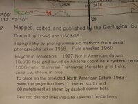
Here is a pic showing this particular Topo Has the NAD83 (US version of WGS84) correction listed in the lower left as 1 meter south then 68 meters east. Add those changes to the NAD27 of the map to get NAD83 corrections
 

Attachments

  • nad83.jpg
    nad83.jpg
    118.1 KB · Views: 706

AUVnav

Sr. Member
Mar 10, 2012
455
86
Primary Interest:
All Treasure Hunting
Arent datums great! When using these different sources, it is very important to understand the datum, how it works, and also how your GPS works.

When using Google Earth, the foundation of what you see is WGS84 horizontally and Vertically. Most of what you see, the terrain DEM is based from SRTM data (Shuttle data) and again is based on the WGS84 Horizontal and the WGS84 ellipsoid for vertical.

Virtually all GPS internal engines use the WGS84 datum for horizontal and the WGS84 ellipsoid for vertical. How the horizontal and vertical information is determined is be particular to your unit. Some have the ellipsoid converted to a grid and use a lookup function, while others calculate with the Vincenty algorithm, or other method. What is important to know is when converting between datums, there will always be an error with the conversion factors. The most accurate methods are to look at what your unit has as the foundation, and use that.
The earth is curved in 2 directions, ie a sphere. If using a GPS to navigate a course, the navigation results will be very accurate when using a straight leg. (ie start at this point and go straight forward at this bearing for a distance) TF or tangent fix. This is because it is easy to calculate this on a single great circle calculation algorithm, the plane being curved in one direction.

When a curved leg is added, RF or radial fix, the calculations become very difficult, in reality, virtually impossible to calculate accurately, as the system is trying to look at the plane bent in 2 directions (ie begin at this point, and calculate the end of a 12nm radius curve that ends going at this bearing)
This solution will vary between manufacturers, and even when iterating multiple times on the same unit. An easy way to check is look at the beginning point of the curve, the distance to the radial point (center of the curve) the radius will be the 12nm entered. Now go to the end of the curve, and review the distance to that same radial point, you will find it can be off significantly, depending on the units built in calculator.

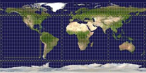
UTM:

800px-Utm-zones.jpg

When using UTM, it equally important to understand how the zones work, and make sure you have the correct information entered. Each zone begins on the map right side and works left. Measurements and data are the most accurate on the right, and will get less accurate (relatively) as you move left through the zone.
More than a few base maps have been significantly off by using the incorrect zone.

In regards to NAD83 vs WGS84, vertical datums,
WGS84 is a fixed global reference frame (i.e., datum):
http://www.wgs84.com/wgs84/wgs84.htm
It uses the WGS84 spheroid. (The datum and the spheroid have the same name.)

NAD83 is a "datum for spatial positioning": http://www.geod.emr.ca/index_e/products_e/publications_e/papers_e/nad83csrs.pdf
It uses the GRS 1980 spheroid.

there are maps that show the errors between the calculations, around a 2 meter difference, but they are pretty close for GP,

Well, thats probably enough gray matter stimulation for now! Good luck and enjoy!
 

Last edited:

TerryC

Gold Member
Jun 26, 2008
7,732
10,990
Yarnell, AZ
Detector(s) used
Ace 250 (2), Ace 300, Gold Bug 2, Tesoro Cortes, Garrett Sea Hunter, Whites TDI SL SE, Fisher Impulse 8, Minelab Monster 1000, Minelab CTX3030, Falcon MD20, Garrett Pro-pointer, Calvin Bunker digger.
Primary Interest:
Metal Detecting
GREAT read, AUVnav! A little too technical for most but I found it very informative. As an avid life-long map guy, I found your post a very good neuron stimulator. Tnx. TTC
 

AUVnav

Sr. Member
Mar 10, 2012
455
86
Primary Interest:
All Treasure Hunting
Thanks! I have to deal with these calculations on a near daily basis, so I get to figure out how all of this works, or nothing will connect. Google Earth is great for the terrain, as it is based on the shuttle data.
It is rather interesting to start looking into the mechanics of your individual GPS as well.

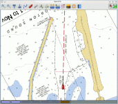
Are you familiar with Open CPN? This a great program, and its free! There are many map background options, such as the USGS topos, nav charts, google earth and others. I run it on my laptop, and purchased a gps WAAS enabled puck for $30, so we are looking at 5m accuracy.
You can put in your course, with google earth as the backround, then use the laptop as the system, great in a boat or small aircraft, or download the course to your handheld...

oc210.gif
 

TerryC

Gold Member
Jun 26, 2008
7,732
10,990
Yarnell, AZ
Detector(s) used
Ace 250 (2), Ace 300, Gold Bug 2, Tesoro Cortes, Garrett Sea Hunter, Whites TDI SL SE, Fisher Impulse 8, Minelab Monster 1000, Minelab CTX3030, Falcon MD20, Garrett Pro-pointer, Calvin Bunker digger.
Primary Interest:
Metal Detecting
Thanks! .... Open CPN? This a great program, and its free!.... download the course to your handheld...

Good deal, AUVnav. I will look into Open CPN. My favorite mapping software is TOPO 4 (2002 series). By openning a window with TOPO and another with GE, I can do a "flip screen" between the two windows, adjusting GE to be the same scale as TOPO. That way, I can add structures from GE to my TOPO pic. Thanks for the info on Open CPN! TTC
 

Top Member Reactions

Users who are viewing this thread

Top