What is the best, Free Topo or gps software for a smart phone.

roadrunner

Bronze Member
Jan 28, 2012
1,230
520
Pinal Mountains,Arizona
Detector(s) used
Garrett Groundhog-2012-1st MD.
White's Goldmaster V/Sat-2nd-MD-2013
Tesoro Lobo-2015-3rd
Primary Interest:
Prospecting

WIDirtFishing

Sr. Member
Apr 29, 2010
322
129
Twin Cities, MN
Detector(s) used
Minelab Equinox 800

Past:
Tesoro Tiger Shark
Tesoro Silver uMax
AT Pro
Primary Interest:
Metal Detecting
Are you trying to bring this device into the field? Or just to use at home?
 

OP
OP
roadrunner

roadrunner

Bronze Member
Jan 28, 2012
1,230
520
Pinal Mountains,Arizona
Detector(s) used
Garrett Groundhog-2012-1st MD.
White's Goldmaster V/Sat-2nd-MD-2013
Tesoro Lobo-2015-3rd
Primary Interest:
Prospecting
Anywhere I go.
May just get a gps unit.
 

Bum Luck

Silver Member
May 24, 2008
3,482
1,282
Wisconsin
Detector(s) used
Teknetics T2SE, GARRETT GTI 2500, Garrett Infinium
Primary Interest:
All Treasure Hunting
I use Back Country Navigator, it's great.

I got the pro version, $10. Worth it.
 

OP
OP
roadrunner

roadrunner

Bronze Member
Jan 28, 2012
1,230
520
Pinal Mountains,Arizona
Detector(s) used
Garrett Groundhog-2012-1st MD.
White's Goldmaster V/Sat-2nd-MD-2013
Tesoro Lobo-2015-3rd
Primary Interest:
Prospecting
Thanks. Will Bc nav let me put in the Lat and Long, and then as I am walking towards it, show the directions, and also show the lat, long, as I am walking?

Right now I have the free version of GPS Essentials.
 

Last edited:
OP
OP
roadrunner

roadrunner

Bronze Member
Jan 28, 2012
1,230
520
Pinal Mountains,Arizona
Detector(s) used
Garrett Groundhog-2012-1st MD.
White's Goldmaster V/Sat-2nd-MD-2013
Tesoro Lobo-2015-3rd
Primary Interest:
Prospecting
They all get service with a satellite,right?
Unless you are in a cave.
 

Bum Luck

Silver Member
May 24, 2008
3,482
1,282
Wisconsin
Detector(s) used
Teknetics T2SE, GARRETT GTI 2500, Garrett Infinium
Primary Interest:
All Treasure Hunting
Thanks. Will Bc nav let me put in the Lat and Long, and then as I am walking towards it, show the directions, and also show the lat, long, as I am walking?

Right now I have the free version of GPS Essentials.

You can put in the lat lon of course and then navigate to it. I don't know if it shows the lat lon as you're walking - I don't see that as useful, and that coming from a math-compulsive former Great Lakes captain. It does have a compass.

I'm having some issues with the AccuTerra maps, but the free ones work fine.
 

OP
OP
roadrunner

roadrunner

Bronze Member
Jan 28, 2012
1,230
520
Pinal Mountains,Arizona
Detector(s) used
Garrett Groundhog-2012-1st MD.
White's Goldmaster V/Sat-2nd-MD-2013
Tesoro Lobo-2015-3rd
Primary Interest:
Prospecting
I have tried to put in the lat long of 2 seperate apps,both free, and can not navigate to them for some reason.
Went to web site and followed the instructions.
Will look again in case I missed something.
 

OP
OP
roadrunner

roadrunner

Bronze Member
Jan 28, 2012
1,230
520
Pinal Mountains,Arizona
Detector(s) used
Garrett Groundhog-2012-1st MD.
White's Goldmaster V/Sat-2nd-MD-2013
Tesoro Lobo-2015-3rd
Primary Interest:
Prospecting
Will have to try gps essentials again, or buy Back country nav pro.
I will re read the directions for gps ess.
Tried to put in a waypoint, then go to it, and it would not accept my new co-ordinates. Just showed my house again.
 

OP
OP
roadrunner

roadrunner

Bronze Member
Jan 28, 2012
1,230
520
Pinal Mountains,Arizona
Detector(s) used
Garrett Groundhog-2012-1st MD.
White's Goldmaster V/Sat-2nd-MD-2013
Tesoro Lobo-2015-3rd
Primary Interest:
Prospecting
I did not know I had to format my coordinates.
Can't just put in long, lat like this.
33. 1412.74
 

GeekNJ

Jr. Member
Mar 10, 2013
35
15
NJ
Detector(s) used
XP Deus & MI-6, Bounty Hunter Land Ranger & Garrett Pro Pointer
Primary Interest:
All Treasure Hunting
There are many different formats to enter in latitude/longitude values. You just need to be aware of the format your software/GPS unit is expecting. Many apps/units default to WGS84 decimal degrees such as 37 23.516 -122 02.625 . You might also see values displayed as degrees minutes seconds ( N37 23 30 W122 02 37 ) and there are others. I'm not sure where you got "33. 1412.74" from in your post but it seems a rather odd value to me.
 

montesactwn

Tenderfoot
Apr 6, 2013
5
0
Yes you can, but in the options menu you have to select the applicable format for lat & longitude. I didn't know there was different ones either but, its kinda like sec min hours...
 

JC Allen

Greenie
Apr 19, 2013
11
3
Rocky Mountains USA
Detector(s) used
Minelab Explorer SE Pro
Primary Interest:
All Treasure Hunting
I went through the same issue last year and here was my solution in detail...

Sadly and most disappointedly, my phone (company) went to iPhone late last year,
so I have now picked up a Garmin ONLY because of this reason!!

One thing to remember! Using GPS (on any device) will SUCK your battery life...
so carry a spare or solar charger if you are going off-the-grid for any longer than 3-4 hours!!


I got in the habit of turning to AIRPLANE mode OR pulling the battery when not actively working
a pre-laid path/track into a location!!

Anywho, the best FREE Android app I found after virtually trying them ALL...hands-down!

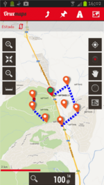
Orux Maps

AND
if you combine it with one of the online services listed below for UPLOADING and/or SYNC'ing tracks, waypoints,
pictures, etc...YOU BECOME A GPS ROCKSTAR (ALL FOR FREE)!!


Here's the "short-list" of a few of my most favorite features...
With OruxMaps you can:


  • Online maps can be cached for offline navigation.
  • Map Creator, from online maps to offline maps :hello2:
  • Offline map viewer. There is an application that lets you create calibrated maps for OruxMaps (see Download and Manual page).
  • Offline layered maps.
  • TrackLog: Record your tracks (gpx, kml format)
  • View old tracks/routes (gpx and kml format)
  • ....
  • Upload/download your Tracks from Everytrail.com
  • Upload tracks to gpsies.com
  • ....
  • Live Tracking with MapMyTracks.com
  • Show coordinates, header, speed, altitude, ...
  • And this is only the beginning!


qr.png

device_01.png A sample map...BUT they have topos, streets, even satellites!!!

Hope that helps you out!!

Take Care,
JC
 

Last edited:
OP
OP
roadrunner

roadrunner

Bronze Member
Jan 28, 2012
1,230
520
Pinal Mountains,Arizona
Detector(s) used
Garrett Groundhog-2012-1st MD.
White's Goldmaster V/Sat-2nd-MD-2013
Tesoro Lobo-2015-3rd
Primary Interest:
Prospecting
There are many different formats to enter in latitude/longitude values. You just need to be aware of the format your software/GPS unit is expecting. Many apps/units default to WGS84 decimal degrees such as 37 23.516 -122 02.625 . You might also see values displayed as degrees minutes seconds ( N37 23 30 W122 02 37 ) and there are others. I'm not sure where you got "33. 1412.74" from in your post but it seems a rather odd value to me.

This is from Google earth, and a couple other places where I get my numbers from:
33 17'47.87" N 111 05'24.36" I meant this is how i put them in, I just did not post the complete formula in my previous post.
 

OP
OP
roadrunner

roadrunner

Bronze Member
Jan 28, 2012
1,230
520
Pinal Mountains,Arizona
Detector(s) used
Garrett Groundhog-2012-1st MD.
White's Goldmaster V/Sat-2nd-MD-2013
Tesoro Lobo-2015-3rd
Primary Interest:
Prospecting
J.C, downloaded it now and will give it a try.
Thanks for all the info.
 

1graeman

Jr. Member
Mar 7, 2013
37
20
Tucson, AZ
Detector(s) used
Minelab Equinox 800, Garrett Pro Pointer
Primary Interest:
Metal Detecting
Check out ATVEscape and Topo Maps, both apps for the iPhone. I also use Google Earth, and AllTrails.
 

Top Member Reactions

Users who are viewing this thread

Latest Discussions

Top